Showing posts with label zinc. Show all posts

Saturday, October 21, 2017

Tinka Update

I'm going to do a different spin on the post, initially focusing on the results and then look at some areas that have been under-drilled to see where Tinka can go to add some tonnes to and/or improve the quality (category) of their resources.

Summary

  • Some good infill holes (A17-085 and 096) in the core of the system
  • System is getting weaker to the east (A17-093) and to the SE (A17-094).
  • Narrow, albeit high-grade zones drilled to the east of the West Ayawilca resource (A17-083 and 085)
  • A few holes were drilled in the Chaucha, Zone 3 and Valley targets, but to date, no significant mineralization was discovered. However, early days.... 

Results

We are now looking at a mature exploration project. Tinka are now drilling the periphery of the South Ayawilca system, so the mineralization is now narrow and deep.

Blue = Sept PR; Red = Oct 2nd PR; yellow = result pending

Here are some sections

Hole A17-087 - SW end of the South Ayawilca Deposit
We can see that mineralization is dying out to the SW.


A17-071 (left) SE extent of mineralization


Mineralization dying out to the NE, but there are a few gaps. Hole A15-041 (to the right) hit multiple zones of moderate zinc mineralization.

The effect that this drilling has had on my officially bad resources is:

Full breakdown of ZnEq resources
We actually see just a slight increase in tonnes, but a decrease in grade. This is due to the slightly lower average grade due to all of the different cut-off limits.

This may sound negative, but essentially Tinka have been drilling at South Ayawilca all year, and have defined a new, deposit at Ayawilca. It will be interesting to see when a new technical report is released.

Opportunities

However, I have a question: Where are Tinka going to drill now? The drilling to date seems to have closed off the South Ayawilca deposit, where are they going to generate future intercepts and grow the resource.

There are 3 areas where they can focus:
  1. Infill drilling - designed to increase the confidence of the resource (increase the amount of M&I resources and reduce the amount of Inferred)
  2. Expansion - drill around the edges and between known mineralized zones.
  3. Green-fields - drilling of new targets
Each of these have a different risk vs reward levels, and I've spent a few days compiling as much of the drilling data as possible from technical reports and old press releases.

They have already started drilling some of the pother regional targets, but unfortunately, so far the results haven't been very positive, but we need to remember that they have only drilled 6-7 holes on them, so it is early days.

So, I will focus on the first two. Where are there: 
  • Under-drilled areas
  • Where some intercepts haven't been followed up on.
NOTE: there may be reasons certain areas haven't been explored (e.g. access issues, topography, hydrology etc.). I'm going to ignore these in this post as I'm not intimately familiar with the project.  

Unfortunately, I'm lazy. Fortunately, Leapfrog can all of the hard work for me. I drew a slice through the project, along the main zinc horizon.


I got leapfrog to create 50m and 100m (radii) buffers around each drill-hole.

Pink = under explored areas
I always do this as it shows me very quickly where there are un- and under-explored areas of a project, and as a simple geologist, I like to put holes in areas where they have a good change of getting high-grade zinc mineralization, like here:


Gaaaaaaapppp

That area is ripe for reaming. This is a perfect area for dumb exploration, simply whack a hole between 'em and you have an easy win! The area to the right of hole A12-008 could also do with a few holes as well, you'll get some decent grades for your PRs there.

However, this raises and interesting question for Tinka. Do they focus on drilling the known mineralization or start exploring the property for more deposits?

If they focus on drilling to improve the confidence in future resource calculations or keep looking for new deposits, and maybe even the BMF?


Thursday, June 15, 2017

Tinka, Tailor, Soldier......Zinc!

Some new results from Tinka, so here is an update!

Summary:

  • Hole A17-063 continued to give some excellent results. The lower zinc zone has been extended by >200m.
  • However, drilling away from the core zone just hit narrow, albeit high-grade zones and veins
  • Good potential to expand resources to the NW of holes 061 and 063 - Tinka are drilling holes 69, 70, 71 and 72 into this area and theses are holes to look out for as they could bring the size of the South Ayawilca deposit to >12Mt @ >7% Zn

I've also updated the Officially Bad (TM) resource table

A nice bump up in resources
I've also built up the Leapfrog Model (you can have a look at the 3D views - link), and included the faults from the plan map on the Tinka Website. I want to see how mineralization is related to the faults.

It sits nicely in the middle
We can see that the best mineralization is found between the 2 green faults. I've drawn a think black line to show what I think is the spine (i.e. the thickest part) of the mineralization.

It would be nice to see some holes to the SW (right) of hole A17-064
When we look at the section, we can see that hole A17-063 hit a high-grade, but relatively deep zinc zone, and the shallow zones hit by holes A17-056 and 061 don't continue to hole 063.

Why? Did they hit a vertical (chimney) zone of zinc mineralization, or is this upper zone hosted in a small, laterally discontinuous unit of favorable host rocks?

Left = horizontal mineralization; right = vertical chimney around hole A17-056
Tinka have been kind and included a map showing where the additional holes have been drilled, but the assay results haven't been released (it does take time to get the samples from the Andes down to Lima for analysis).


Monday, May 15, 2017

Tinka - Ayawilca

We have seen some decent hits from Tinka's Ayawilca project in Peru.


  • 62.4m @ 5.6% Zn, inc. 17.9m @ 11.6% Zn (link)
  • 51.9m @ 10.1% Zn, 62 g/t Ag (link)
  • 18.6m @ 10.4% Zn and 52 g/t Ag (link)


Summary


  • Drilling has hit multiple high-grade zinc (with Ag credits) lenses over a ~200m length
    • officially bad tonnage guesstimate = 8Mt @ 4.7% Zn
    • including a 2.3Mt core grading 7.2% Zn
  • Early days, mineralization open to the north and south
  • Faulting may have a significant impact on size of the deposit.


I've brought the data into Leapfrog Geo (you can get the 3D viewer file from here (link), back calculated the residual grades to see how everything looks.

Zinc

Multiple lenses
Silver

Silver is essentially in the same place as zinc
Lead

Lead is restricted to a few, narrow zones.

We see a number of zinc lenses, that appear to pinch-out to the NW and SE. What will be critical is what the faults (dashed black lines) do to the mineralization, are they:

  • Pre-mineralization – minimal effect, but could have some high-grade Zn (+Ag) mineralization up them
  • Post – offset the mineralization – i.e. the mineralization could be deeper or shallower
I was intrigued by the zonation (?) in different metals:

  • Zinc appears to be relatively consistent, forming continuous >5% zones between the drill-holes, but there does appear to be higher grades in the Northwest.
  • Silver - there are higher grade silver zones, several appear to be close to the northwest (left) fault, and there is a nice high-grade zone at depth.
  • Lead - minimal lead, some high-ish grade intervals associated with the NW fault, but in general the Pb levels are very low.
It does appear that the NW fault could be an important controlling structure and may have some high-grade mineralization (a chimney) associated with it. It was a shame that hole A17-059 wasn't pushed on a bit further to test this fault at depth.

Hole 58 is interesting, does it show a continuation of this zinc zone to the NW or is it a separate zone or related zinc vein.chimney associated with the NW fault zone?

I did a quick and dirty 'resource' tallying


So that is a good start, so why don't we look at the upside


A Crap doodle - i'll be updating this

You can clearly see that the zinc zone is open to the NE and SW, and will offer good potential to define a good chunk of mineralization, as this zone is ~300m wide and so far drilling has focused (6 holes - 56A was an extension of 56, so i'm counting it as 1 hole), on a 100m section.

I'm also interesting to see what hole 59 will hit. I'm not very confident (maybe a couple of narrow zones) as mineralization is pinching out towards the NW fault, and my gut feel is that this fault is an important controlling structure, which either controlled the ore bearing fluids or has offset the mineralization.


Saturday, April 22, 2017

Taylor question

I want to ask you all a quick question, I mentioned that the different ore zones at Taylor have different recoveries.

If a deposit has very poor recoveries, should it still be allowed to state it's resources?

I've only included the Zn recovery as it forms the basis of my question.


We can see that they get very poor recovery (2.2%) from the single metallurgical sample* from the Scherrer zone.

*for the case of semantics I'm going to assume that this single sample is representative for the entire 14.3Mt resource for the Scherrer Zone.

According to the Taylor resources they have calculated that the Scherrer zone contains:

  • Indicated Resources = 6.2Mt @ 6.5% Zn, 5.6% Pb, 0.2% Cu and 2.7 oz/t Ag or 14.7% ZnEq
  • Inferred Resources = 8.1Mt @ 9.5% Zn, 7,4% Pb, 0.2% Cu, 3.1 oz/t Ag or 19.9% ZnEq


It is (according to table 14.10) the 'best' zone in the entire deposit. However, the zinc recovery in the Scherrer zone is 2.2% (table 13.5 in the PEA), is this zone still good enough to be called 'ore'?

Let us recalcalculate** the ZnEq% for this zone:
  • Ind Res = 6.2Mt @ 6.5% 0.143% Zn, 5.6% Pb, 0.2% Cu and 2.7 oz/t Ag or 8.3% ZnEq
  • Inf Res = 8.1Mt @ 9.5% 0.209% Zn, 7,4% Pb, 0.2% Cu, 3.1 oz/t Ag or 10.6% ZnEq
**I've only applied the recovery percent to the zinc grades due to a massive bout of laziness

So this now takes the Scherrer zone from being the best zone to the worst (I'm ignoring the andesites as they are so small) zone. It is still economic to mine, but this is a quick demonstration for why I believe that companies should be using RECOVERABLE metal grades when they calculate equivalent grades.

Or put it another way, imagine that AZ spent ~$400M to build the mine, they are focusing on mining the 'best' ore, which according to the resources is the Scherrer Zone. They start mining, sending ore to the mill and suddenly find that all the zinc is disappearing to the tailings dam, this will cause a few problems like:

  1. Losing 40% of their revenues
  2. Possible environmental penalties as there may be quite strict limits on the amounts of lead and zinc that could be discharged to the tailings pond
  3. those fun, high confidence inducing press releases stating that "the ore is more challenging than expected", "processing difficulties", "additional test-work required" and the like.
It sounds like I'm picking on AZ, I'm not, I just though that this was a nice and easy example of a common practice in the exploration industry, and AZ provided some decent data to show it.

Tuesday, February 7, 2017

Hermosa - drilling update and geology review

We've got another batch of drill results from Hermosa (link and link).

Summary

  • Majority of the new assay data is from infill holes (7 of 10 holes) that intersected similar grades to surrounding holes
    • We see a lot of grade inflation - thick zones are in reality a much narrower high-grade zone, surrounded by low grade rocks (e.g. hole 403)
  • NW DH looking for the continuation of Taylor weren't anything special:
    • Deep, narrow, low grade CRD mineralization - it looks like the system is dying out in this direction
    • Shallow, high-grade vein mineralization - maybe this should be their focus for future drilling in this area?
  • Permitting - Arizona Mining are pushing shit uphill with this project, mate.


Technical junk

Here is the accompanying map for the first release, with my annotations to help you understand the maps a bit better.

Taylor deposit drilling - Jan 17th PR (Source: Arizona Mining website)
Here is a another version showing the location of the private (patented) mineral concessions and public (unpatented - i.e. where AZ can't drill) land.
Red hatched areas = can't drill here
and looking regionally
Green shaded areas = public land, unshaded areas are private land. Taylor deposit is at the bottom of the image.
Not many places for picking and poking with drilling

Arizona mining did want to drill in the public land, but unfortunately their recent application for 8 holes was cancelled (link), and they have another permit for 5-6 exploration holes that are on-hold.


You can download the enture permit application and maps from here (link).

A big thanks to LM for that info.

The Question is this:
Do Arizona management need to inform their shareholders and the market that their permits to explore on public land have been cancelled? Is this of material importance to the project?

I feel it is, but then again, I'm a geologist and know nothing


As I have mentioned before, if they cannot get a permit to drill on public land, how can they believe that they can obtain the numerous permits to build and operate a mine, where potentially a large portion of the infrastructure, tailings and mine dumps will probably be (like for the Central Deposit) on public land? 

This is going to make the PFS study very interesting. Will they:
  1. Do a cop out - not have any plans for the surface infrastructure
  2. Do a Central - have plans for the surface infrastructure in the optimal locations (i.e. a large portion on public land) where you know they can't do anything
  3. Try and squeeze everything into the private
I'm 50:50 between (2) and (3).

Geology Crap

Here is a long section through an idealized CRD deposit (source - Pasinex Adana deposit (link) and Dr. Peter Megaw)


and here is an annotated long section through Taylor


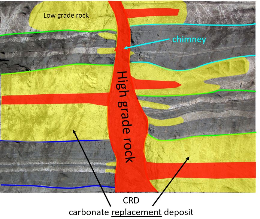
It looks very similar to Peter's model, which is good, and you can see that there are 3 distinct styles of mineralization:
  1. CRD horizons - black dashed lines - these are dipping to the left (NW), and individual horizons are very extensive and have been drilled over lengths of >1km with relatively consistent mineralization. These are a nice steak.
  2. Chimneys - mineralization restricted to narrow (100m x 200m) vertical zones, with sharp grade contacts (i.e. outside of the chimney grade is very low). Think of these as a bottle of wine - all the good stuff is inside. 
  3. Veins - narrow, very high grade vertical structures. Think of these are those thin sheets of chocolate that you get stuck in desserts in fancy restaurants. They are great, but there is never quite enough.
Thee zones are very different (grade, style, orientation) and if you use a 'generic' control (i.e. assume that all the mineralization is horizontal), you may be over or underestimating the amount of mineralization in chimney zones. This is where infill drilling really helps to define the extents to mineralization.
  • Ante Mineralum
  • Post Mineralum


Source (link) - Photo of Fault with Fault Breccia by James S. John - I know it is the wrong rock type (Taylor is in limestone), but it was such a good photo showing bedding and faulting.

The Press Releases

This is where the holes were drilled


Blue = Jan 17th PR holes; red = Jan 26th PR holes
19th Jan - assays released from 7 drill-holes.
  • 4 holes (HDS-388, 397, 398 and 400) were drilling into the core of the Taylor deposit 
    • These are infill holes (i.e. drilling between earlier holes that hit mineralization)
    • Low risk drill-holes as the earlier holes surrounding them give you a good idea of what you will hit.
  • 3 holes (HDS-384, 390 and 392) looking for the NW continuation of the Taylor horizons. 
    • These are (relatively) high-risk holes, as the main Taylor horizon is very deep (>1000m) here.
      • Deep = expensive drilling.
    • Results were poor, the CRD zones are thin and low-grade. However, the holes did hit some shallow, high-grade vein mineralization.
26th Jan - assays from 3 drill-holes.
  • All holes were infill holes designed to better understand the Taylor deposit mineralization and to convert inferred into indicated resources. They won't have much impact on the overall tonnage of the deposit.
  • Holes intersected narrow high-grade zones, surrounded by lower grade mineralization - this could have an impact on reducing the overall grade and tonnes of the deposit.

NW Holes

Here is a section through the deposit. I've added scale bars so you can see how deep AZ are drilling.
Holes 390 and 392 hit mineralization at ~1100-1200m depth (it is probably costing them at least $200K/hole to drill to that depth).

CRD zones = red lines.

We can Also see that the 2 main Taylor CRD zones stop between holes 401 and 392. So it looks like resource expansion to the NW is limited as best. I can;t see them drilling more holes in this area, unless they are going to focus on the shallow, high grade veins.

Central Zone

Here we see the chimney effect, in the chimneys we get much thicker and higher grade material, and when you look at the results in more detail, we actually see that these thick zones are really several, narrower high grade (>5% Pb) zones surrounded by marginal grade rocks.

Please note - I've used lead to highlight the high-grade zones
Here we see the grade in the BEST HOLE EVER - look at how the upper high grade zone is essentially gone in the holes that are only 70m away. You can also see how there is drastic grade changes between holes as well - the narrow (10m wide) high grade zones appear to continue some distance (these are probably representing replacement of specific beds in the limestone - see images above) but the thick zones don't. So what do you do in this type of situation? You have 2 options:

  1. Cram as many holes into that area as possible that may significantly reduce change the size of this high grade zone, but would give some spiffy PR headlines
  2. Treat this area as a "Zone of Avoidance" - if we don't touch it, we won't break it approach - this leaves a nice chunk of inferred resources but preserves its virtue and make sure it stays nice and large (and relatively undrilled).


So, for me, I think Hermosa is a large base metal resource, but no more. The local communities have successfully prevented any mining or exploration activities from being conducted on public land (not just for Arizona Mining but for several other companies as well), and I can guarantee that the PFS and FS due in Q1 and the end of 2017, will show how robust the economics of the project are, but if you can't get permits, the zinc, lead and silver are going to stay in the ground.

3D model can be found here (link)

Thursday, January 12, 2017

Hermosa - January Update

AZ released some spiffy new drill-results today (link)


When you look at the accompanying plan map, you can see why the results from hole 396 were good, and the other holes didn't really hit much, just a few narrow zone and veins, so we'll ignore them.

high grade zone circled in red
When we zoom in, we can actually see that hole 396 wasn't a huge intercept of medium grade mineralization but a series of narrower high grade (>10%) zones within a large zone grading between 2.5-5% Zinc.

Red >10% Zinc; Blue 2.5-5% Zinc
Hole 396 was drilled to follow-up on the thick intercepts in holes 333, 334, 335 and 374. When you step back you can see that there are a couple of areas where the mineralization is much thicker than everywhere else.

Central zone centered on hole 333, 334 and 396; second zone centered on hole 104
You can see that there are 2 distinct orientations to the zinc mineralization:
  1. Predominant - A series of sub-horizontal (dipping down to the left or northwest) zone related to rock contacts and the basal low angle fault.
  2. Vertical pipes (?) of base metal mineralization - most likely related to vertical faults being used as conduits for mineralized fluids.
This is important as for accurately calculating the resources you need to model each zone separately, with their own bias to the direction (search ellipse) that the mineralized intercepts are joined together to link adjacent drill-holes. This is important for fault hosted mineralization (the vertical stuff) as the fault zone could be very narrow (a few tens of meters) and very high grade.

Check out the copper distribution:


The copper appears to show a bit of zonation. the deeper mineralized horizon is much richer than the upper Zinc horizons, except where you see those nice thick intercepts, is that telling us something? You would expect to see elevated copper in the hotter parts of the system, deeper or nearer the source intrusive, but also where you get zones of weaknesses where fluids will be focused.

In Summary, a good hole, but not an unexpected one. I'll be guessing that we'll be seeing a lot more holes being drilling into this zone over the coming months.

If you want, you can download the 3D model from here (link).


Tuesday, January 3, 2017

Hermosa - (lack of) Talent Section

Metallurgy and ore zones

I'm always suspicious of metallurgical data. Junior companies like to skew the results for Maximum Impact (tm) by sampling the best and highest grade material (to steal a yank term - the 'winningest' ore) to maximize recoveries. As we saw with Sandra Escobar, often (i.e. always) the high-grade material is very different (in form and style) to the majority of the material that forms a 'deposit', and there can be drastic differences in recoveries for low, average and high grade material.

Fortunately, AZ keep us calm with this from the latest technical report:
all is good
At Taylor we can see that AZ sent a single, 139lb, representative (for a 100Mt deposit - or just 0.0000000063% of it) for metallurgical testing. It was a composite made from 18 separate samples.


You can see that the grade of the met sample is twice that of the resources (not exactly representative), and we can see in the table above that there are huge range in grades from the individual 18 samples making the composite (I've included my spreadsheet with the 3D model (link).
  • Lead: 7.99% vs 4.4% (range - 1.17% to 28.43%)
  • Zinc: 7.98% vs 4.7% (range - 1.11% to 22.8%)
  • Silver: 3.53 oz/t vs 1.8 oz/t (range 0.53 to 14 oz/t)
  • Copper: 0.28% vs 0.1% (range 0 to 1.32%)
  • Manganese: 1.32% (range 0.68% to 10%) - we have no 'official' Mn numbers in the resources
So it isn't a representative sample. As a prelim study it shows that you get very good recoveries for Pb, Zn and Ag from high grade ores, but will we see similar recoveries for average and low grade material that makes up the majority of the deposit?

My gut feel is yes, but i'm going to estimate that it will be a few percent lower (i.e. high 80s for Pb and Zn), but it would have been nice that AZ used these recovery values for the ZnEq calculation!

I also found these sections interesting. You can see that the Hermosa Central oxide zone extends down into and separates the upper and lower sulfide zones. Is this contact sharp or do we have a more complicated zonation from oxide through a mixed zones (with both oxide and sulfide minerals) into the sulfide zones?
Some rusty stuff in the middle like jam in a black forest gateau
This is important as each zone will have different characteristics (for mining, treatment) and  recoveries for each metal. We know the Central deposit contains significant manganese (it was being promoted as an Ag-Mn deposit), is the manganese evenly distributed throughout Central-Taylor or restricted to specific areas?

Would we also see a corresponding drop in Mn values in the concentrates? I was intrigued, so I went a bit further and brought in the location of the samples that were collected for the metallurgical sample to check that the samples were not just taken from a single hole but were spread throughout the deposit.

That manto is a bit of a prick

Ohh, we can see that the samples were collected throughout the deposit. However, a few appear to have been collected within or very close to the manto oxide zone, and they appear to contain a lot more Mn (>5%) than the samples taken from the deeper sulfide zone (<2%).

If you take away the samples containing more than 5% Mn, the grade of the composite drops from 3.42% Mn to 1.79% Mn, and if we use bad maths:

  • Original met composite grade = 3.42% Mn gave a concentrate grade of 1.33% Mn
  • TAG's composite grade = 1.79% Mn - would this give a concentrate grade of 0.7% Mn?
    • I have no idea if this is good or bad, but it may be more manageable than 1.36%

It looks like AZ were focusing on maximizing the Pb and Zn recoveries (from their representative metallurgical sample), and have appeared to have FUBAR-ed the deposit by carelessly including a few samples with a metric F*ck-tonne (I'm using official SI units here) of manganese.

Imagine if AZ had been clever and had known that Mn was an issue in Zn concentrates (I admit that I didn't). They could have trawled through their assay database and picked good samples with low Mn values for the metallurgical sample and no-one would have known.

oops
You missed a trick, now you get to have nice awkward interviews on BNN, every investor, newsletter writer and awesome mining blog dudes irritating the shit out of you by asking....


Tuesday, November 1, 2016

Nevada Zinc - not all Zinc deposits are equal

My chum down south has been beating the drum recently about Tinka and their base metal project in Peru and showing us lots of lovely charts about how zinc prices have been shooting up. So, I took his advice and bought shares in Teck....

I can't see a difference.....
So I thought I would try and be clever and went looking for companies with zinc projects, and I stumbled on Nevada Zinc (link), they have been hitting some great zinc intercepts from their Lone Mountain project in Nevada.

I thought, at last I've found a decent project that no-one knows about, but a crap load of shares and wait for the retail investors to pile in and make me rich (ok, being realistic - slightly less poor).

I brought the drill-data into 3D (you can get the model from here).

look at those grades....

magnificent, thick, juicy zinc intercepts
Everything was looking good until I saw this in their presentation (slide 16) where it states: "Potential for sulfide mineralization at depth"

Crap, we have a zinc carbonate deposit. How many of those are operating around the world? I only know of one - the Skorpion Mine Namibia (link), that produces around 125Kt of zinc metal a year from a alluvial zinc deposit.

All other carbonate zinc deposits I know are hosted in limestone:
  • Accha and Yanque in Peru (Zincore Metals Inc (link))
  • Sierra Mojada in Mexico (Silver Bull Resources (link))
  • The tops of zinc deposits (e.g. Tsumeb, Broken Hill and the MVT deposits in the USA, UK and Ireland that were mined in the 18th century,
So they aren't common, but Skorpion is/was the 8th largest zinc mine in the world, that is good, no?

Skorpion is a bit different, most non-sulfide zinc mines are generally found in limestones, and you know what happens when you tip a load on acid on them, they fizz. Hypothetically you can leach the zinc minerals, but will have massive acid consumption.
Don't worry, Nevada zinc state that they can use dense media separation (DMS) to remove a lot of the waste and they they can leach the zinc, but that is the big issue, the real elephant in the room is the lead.

There is a bit of lead...
There isn't much, but lead carbonate, so what's the problem? Well lead carbonate is romantically called "white lead" and for the older readers it was used as a pigment in paint. Those of you who are or have renovated an old house, you know what a hemorrhoid it is to remove and dispose of the old paint.

This is what Wikipedia tells us:

It tended to cause lead poisoning, and its use has been banned in most countries...

So why is mining lead carbonate bad? Why don't we ask Magellen Metals what they think (link)?

Magellen (now called Rosslyn Hill Mining) operated the Wiluna Mine in Western Australia (link). A oxide lead-zinc deposit. Back in 2006 it was noticed that ~9000 birds died in the town of Esperance, that was discovered to be caused by lead poisoning. The source of the lead was the concentrate from the Wiluna mine that was using the port at Esperance to ship the concentrate overseas.

They also found that 10% (about 1400 people) have blood Pb levels above WHO levels. The concentrate contained lead carbonate which is absorbed much more easily that lead sulfide. The end result was that they had to pay AU$30M to clean up Esperance, and were very much under the microscope from the state government. the mine is currently closed.

So, Nevada Zinc have a carbonate zinc deposit in the USA, a country well know for being incredibly environmentally friendly. Imagine the fun you'll have with the EPA over:
  • Mining ore with lead carbonate - you gonna need good dust control
  • Transporting concentrate with lead carbonate in it
  • Having waste dumps on surface that may contain lead carbonate
    • they don't have any wind in Nevada?
I'm surprised they haven;t had a slap on the wrist for doing RC drilling, which looks like this...


Bit like a steam train, puffing all that dust over the desert. Imagine that dust contained something nasty.....

So in essence, not all zinc deposits are created equally, and if you see a company talking about their great oxide zinc depoist (e.g. Zincore, Silver Bull, Nevada Zinc), just ignore them and move on.