Wednesday, June 28, 2017

Cascabel - Latest Results

We got results from 2 more drill-holes from Alpala last week (link).

I've plugged the numbers in and this is what it has done to my officially bad (tm) contained metal calculations.

Copper


We have a 14% increase in tonnes and an equivalent increase in contained copper

Gold


Here we have a 10% increase in tonnes and 8% increase in contained gold, so a minor (1%) decrease in grade.

This is some very unfashionable results, normally companies like to drill huge amounts of low grade and amaze everyone with the total contained ounces of gold and tonnes of copper.

So where did these results come from?

Starting to look quite big
Hole 25 was drilled 200m to the SE of hole 19, and below historic hole 13-003 that terminated before it hit the main zone Cu-Au mineralization. It hit a 100m zone of high-grade mineralization from 772-872m but quickly passed into low-grade/marginal material.

It suggests that there could be better mineralization to the NE, maybe an additional hole could be drilled from same platform to the NE?


Hole 24 was disappointing, it was drilled 500m to the SE, and hit a narrow (~50m true width) interval grading 0.65 g/t Au and 0.63% Cu, surrounded by very low (<0.2% CuEq) grade mineralization. It looks like hole 24 just clipped the very edge of Alpala mineralization.


You can get the LF viewer file from here (link).


Tuesday, June 27, 2017

Camino Rojo Opinion

This is just a quick post on the Camino Rojo sale by Goldcorp, who have taken a large write-down, but where there any red flags that undermined the value of Canplat's asset?

Summary


  • Proximity to the property boundary prevented development - drilling by Fresnillo has identified the continuation of the Represa zone and potentially up to 25% of the resources are owned by them
  • Metallurgy - generally poor silver recovery
    • Oxide ore = ~85% Au recovery but only ~30% Ag recovery
    • Transitional = 30-60% Au recovery; 30-40% Ag recovery
    • Sulfide - not reported, I'm guessing that Goldcorp has worked on this.
  • Mining - 2009 pit only focused on Oxide/transition ore
  • Drilling by Fresnillo appears to have found another body, suggesting that additional mineralization could be found in the area
Any development of the main (Represa) zone will need to involve Fresnillo. Can Orla do this, or will their focus be on exploring the property for additional mineralization?

Maybe one option could be something similar to Juanacipio. Do a deal where Fresnillo are the operators and Orla can maintain a minor interest?

Geology Crap

Camino Rojo is an interesting project, according to the last 43-101 filed by Canplats in 2009 it contained the following resources:

A decent resource
Looking at Goldcorp's Dec 2015 resources (link), the resources have increased significantly to:


That is a decent increase, they've added ~6Moz Au and kept a similar grade, which is good. However, when we look at where the drilling is located, we can see a major issue:

red line = property boundary
We can see that the deposit runs right to the edge of the property, and we can see an area of drilling in Google Earth on the other side that indicates that Fresnillo have found the continuation!

We can also see to the NE a second area of drilling that suggests that there are other mineralized bodies in the area. So, if there is a deal to be done, Fresnillo won't be selling cheaply as they could be sitting on >5Moz Au!

I imported the Canplats data into Leapfrog (viewer file here), to have a closer look.

Even the proposed pit crosses the property boundary
Some sections
Black line = proposed pit; blue line = property boundary


Black line = proposed pit; blue line = property boundary
A 3D view

left = Fresnillo; right = Goldcorp
So drilling defined an Au-Ag zone that is ~650m thick right next to the property boundary, and then, Goldcorp have spend >$100m expanding those resources.

Why were Goldcorp not able to do a deal with Fresnillo to acquire the adjacent concession? Did they want to much? If that is the case, what chance to Orla have on developing the project?

I still think it is an interesting deal for Orla, but when is the game plan? I see 2 options
  1. Look for more deposits - drilling has found at least 2 and this is a new (discovered in 2008) camp where drilling has already defined >10Moz Au (I'm assuming that Fresnillo has found something)
  2. Do a JV with Fresnillo with Fresnillo being the operators and Orla having a 40% interest.

We can see that there are a lot of targets around the property, and a well funded exploration campaign could turn up 2-3 new deposits in an emerging camp. 


Thursday, June 15, 2017

Tinka, Tailor, Soldier......Zinc!

Some new results from Tinka, so here is an update!

Summary:

  • Hole A17-063 continued to give some excellent results. The lower zinc zone has been extended by >200m.
  • However, drilling away from the core zone just hit narrow, albeit high-grade zones and veins
  • Good potential to expand resources to the NW of holes 061 and 063 - Tinka are drilling holes 69, 70, 71 and 72 into this area and theses are holes to look out for as they could bring the size of the South Ayawilca deposit to >12Mt @ >7% Zn

I've also updated the Officially Bad (TM) resource table

A nice bump up in resources
I've also built up the Leapfrog Model (you can have a look at the 3D views - link), and included the faults from the plan map on the Tinka Website. I want to see how mineralization is related to the faults.

It sits nicely in the middle
We can see that the best mineralization is found between the 2 green faults. I've drawn a think black line to show what I think is the spine (i.e. the thickest part) of the mineralization.

It would be nice to see some holes to the SW (right) of hole A17-064
When we look at the section, we can see that hole A17-063 hit a high-grade, but relatively deep zinc zone, and the shallow zones hit by holes A17-056 and 061 don't continue to hole 063.

Why? Did they hit a vertical (chimney) zone of zinc mineralization, or is this upper zone hosted in a small, laterally discontinuous unit of favorable host rocks?

Left = horizontal mineralization; right = vertical chimney around hole A17-056
Tinka have been kind and included a map showing where the additional holes have been drilled, but the assay results haven't been released (it does take time to get the samples from the Andes down to Lima for analysis).


Saturday, June 10, 2017

Camino - Road to Chala

Tired if working the traveling sideshow circuit investment show circuit in Canada, the Camino Dream team, got tangled up with raising 5 million loonies, but have triumphantly returned with some core, from driest, sandiest Peru.

so beautiful...

Summary.

Negatives
  • Poor correlation between diamond hole and earlier high-grade RC hole
  • Presence of Acid Soluble copper throughout the hole - could this lead to metallurgical complexities?
Positive
  • DCH-001 intersected a third, deeper zone(s) of Cu mineralization (27m @ 1.63% Cu)
I was disappointed that there was such a discrepancy between holes CHR-002 and DCH-001.
  • Original Hole - CHR-002 = 106m @ 1.3% Cu
    • inc. 38m @ 2.12% Cu
  • Twin Diamond hole - DCH-001 = 168.5m @ 0.72% Cu
    • including a couple of ~10m zones grading >1% Cu
We can see that visually:

those holes are only 10-15m apart - much less red stuff in hole DCH-001!

So, we have 2 holes, drilled right next to one another that have returned significantly different results. I'm ignoring the PR intervals and looking at the individual samples (the colored bars) and you can see that there are significant differences between the holes. Are we seeing sample bias caused by the RC drilling? It may have:
  • Washed away of fines and lighter material (i.e. the gangue)
  • Caused dilution and mixing of grade across zones, particularly at the water table
Or, do we have a very heterogeneous zone of mineralization, with significant changes in grade over small distances?

My feeling is that the RC drilling has produced non-representative sample, and for me it will be interesting to see what is reported in the diamond holes.


Here are my annotated notes for this section, just to highlight some important areas.

Add caption
I'm also intrigued with the Magnetite rich zones. They have been interpreted as being horizontal, but the cool thing with Leapfrog, you can test a variety of ideas.

Are they horizontal?

cross section through Adriana


Are they vertical?

vertical dykes (grey)
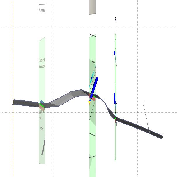
We can see that there is a significant difference in the depth to the magnetite-rich unit between sections, and the vertical interpretation could be an reasonable alternative, I'm thinking that there could be a series of vertical post-mineral (i.e. after copper) dykes cutting through the project.

You can get the Leapfrog viewer file from here (link).


Just some feedback for Camino, could you get someone to review your PRs before you set them free?
loads of errors
You have some typos, using the wrong units and refer to gold assays in the blurb below the table - or is the AssCu number meant to be gold?


Monday, May 15, 2017

Tinka - Ayawilca

We have seen some decent hits from Tinka's Ayawilca project in Peru.


  • 62.4m @ 5.6% Zn, inc. 17.9m @ 11.6% Zn (link)
  • 51.9m @ 10.1% Zn, 62 g/t Ag (link)
  • 18.6m @ 10.4% Zn and 52 g/t Ag (link)


Summary


  • Drilling has hit multiple high-grade zinc (with Ag credits) lenses over a ~200m length
    • officially bad tonnage guesstimate = 8Mt @ 4.7% Zn
    • including a 2.3Mt core grading 7.2% Zn
  • Early days, mineralization open to the north and south
  • Faulting may have a significant impact on size of the deposit.


I've brought the data into Leapfrog Geo (you can get the 3D viewer file from here (link), back calculated the residual grades to see how everything looks.

Zinc

Multiple lenses
Silver

Silver is essentially in the same place as zinc
Lead

Lead is restricted to a few, narrow zones.

We see a number of zinc lenses, that appear to pinch-out to the NW and SE. What will be critical is what the faults (dashed black lines) do to the mineralization, are they:

  • Pre-mineralization – minimal effect, but could have some high-grade Zn (+Ag) mineralization up them
  • Post – offset the mineralization – i.e. the mineralization could be deeper or shallower
I was intrigued by the zonation (?) in different metals:

  • Zinc appears to be relatively consistent, forming continuous >5% zones between the drill-holes, but there does appear to be higher grades in the Northwest.
  • Silver - there are higher grade silver zones, several appear to be close to the northwest (left) fault, and there is a nice high-grade zone at depth.
  • Lead - minimal lead, some high-ish grade intervals associated with the NW fault, but in general the Pb levels are very low.
It does appear that the NW fault could be an important controlling structure and may have some high-grade mineralization (a chimney) associated with it. It was a shame that hole A17-059 wasn't pushed on a bit further to test this fault at depth.

Hole 58 is interesting, does it show a continuation of this zinc zone to the NW or is it a separate zone or related zinc vein.chimney associated with the NW fault zone?

I did a quick and dirty 'resource' tallying


So that is a good start, so why don't we look at the upside


A Crap doodle - i'll be updating this

You can clearly see that the zinc zone is open to the NE and SW, and will offer good potential to define a good chunk of mineralization, as this zone is ~300m wide and so far drilling has focused (6 holes - 56A was an extension of 56, so i'm counting it as 1 hole), on a 100m section.

I'm also interesting to see what hole 59 will hit. I'm not very confident (maybe a couple of narrow zones) as mineralization is pinching out towards the NW fault, and my gut feel is that this fault is an important controlling structure, which either controlled the ore bearing fluids or has offset the mineralization.


Tuesday, May 2, 2017

Solgold - update

DISCLOSURE - I own shares in Sol Gold. I'll try to make this post unbiased, but I want everyone to buy lots of shares so that I can make some money!

We got some news a couple of weeks ago that gave us the final results for hole 21 and a PR today with some visual results from hole 23R, 24 and 25.


Hole 23 was drilled right through the middle of Alpala and will get some great results. Holes 24 and 25 were drilled to test the SE continuation of the Alpala system. They hit ever decreasing thicknesses of gradually lower grade mineralization, which is what you would expect as you move away from the core of the system.

Here are the updated official bad estimates


  • Copper increased to 1.9Mt
  • Gold increased to 4.95Moz 
Looking good, but we see that there is a smaller increase in high grade (>0.6% Cu and 0.5 g/t Au), which is the material that will be mined via and underground block-cave operation.

My prediction:

  • Hole 21 - 925m @ 0.5% Cu, including a 400m >0.6% Cu - hole only 100m from hole 16, which hit a lot of good stuff
  • Hole 23 - being drilled, target between holes 16 and 19, so I'll expect
    • 200m >1% Cu and 1 g/t Au (@ 1,000m depth), within a 1000m zone of 0.3-4% Cu and 0.2-0.4 g/t Au

Actual

Hole 21
  • 844m @ 0.73% Cu and 0.43 g/t Au
    • inc. 670m @ 0.82% Cu and 0.51 g/t Au
    • inc. 304m @ 0.99% Cu and 0.63 g/t Au
So, I was a bit-off, sort of like my high-school review - has talent, just needs to work harder.

Hole 23 

  • 573.2m of sulfides from 563.7m depth
    • at >1.4% volume percent chalcopyrite
    • or a guesstimate grade of 0.48% Cu
  • a higher grade zone from 979.2m to the current EOH at 1136.9m
    • at >2.9 vol-percet Chalcopyrite
    • or a guesstimate grade of 1% Cu
Hole 24 - 248m @ >1.1 volume percent chalcopyrite or 0.38% estimated copper

Hole 25 - 454.2m @ >1.5 volume percent chalcopyrite or 0.52% estimated copper

I calculated the guesstimate grades by taking the volume percent of chalcopyrite and multiplying it by the copper content of chalcopyrite

so 1.4 * 0.346 = 0.48% Cu

However, it is very hard to accurately measure the grade visually, so we can use these as guide to where copper is present or absent.

NOTE: I haven't used the estimated copper grade in the tonnage calculations.

Here is the updated leapfrog model (link)

Geology

It is hard to gauge the importance of hole 24 as it is still being drilled, but from the information we're given:

  • Hit a narrow low-grade copper zone 400m away from other mineralized drill-hole
  • 248m @ 1.1 volume percent chalcopyrite or 0.38% Cu from ~740m depth.
porphyry getting thinner to the right (SE)
We can also see that hole 25 (454m @ 0.52% Cu) is also a step down from the high-grades hit in hole 21 in the core of the system. This indicates that we are moving away from the high grade core into the lower grade periphery. 

This is normal in porphyry systems - you have the thickest, highest grade mineralization in the core of the system and lower grade at the edges.

Drill-hole 23 was drilled smack into the middle of the high-grade core, so this will get some decent mineralization, but won't have a huge impact on tonnes (see section below). I will expect it to hit good copper grades until around 1300m depth. I'm going to upgrade my guesstimate to:
  • high grade (>0.8% Cu) from 980m to 1350m
Hole 23 - drilled straight through the guts of Alpala.


Thursday, April 27, 2017

Camino Minerals - initial review

Camino have released some interesting results from the Los Chapitos project in southern Peru (link and link)

Summary

  • Good
    • Great result from hole CHR-002
      • but, we have grade smearing, outside the >2% zone, it drops off to 0.84% Cu, still good, but could be marginal for an open pit operation
    • Small, near surface oxide zone
    • Some other interesting targets to be tested around the property
  • Bad
    • It was a shame that they went with cheapo RC drilling option as it meant:
      • Hole 002 terminated in good copper mineralization
      • Holes 004 and 005 couldn't reach the extension of this zone.
    • Typical grade 'expansion' - the high grade (>1% Cu) is found in narrow zones surrounded by low grade (0.2-0.3% Cu).
  • Trench samples look good, but I'm skeptical of trench sampling as:
    • remember - you can bias them by sampling along a mineralized structure rather than sampling across it - the FAG will explain how you can 'improve' your trench results
Is water, or the lack of, going to be an issue?

They are drilling using an reverse circulation rig, so as they mention in the March 29th PR (link), so they will be drilling 200-300m/day and they will finish the program about now....

There are advantages and disadvantages with using an RC rig:
  • Advantages
    • Quicker - drill 200-300m per day compared to 50-100m for a diamond drill
    • A lot cheaper - ~50% of the cost (or even cheaper) of a diamond rig.
    • Doesn't need water - very useful in the Atacama desert
  • Disadvantages
    • Lower quality geological information
    • greater deviation - the holes drilled by Camino started at 45 or 50 degress, but steepened to almost 80 degrees at the end of the hole.
      • if you see any company not-surveying RC holes, that is a good sign that they don't know what they are doing and that the data from these holes are suspect as they can't accurately tell you where the mineralization is located.
    • bigger visual impact
    • require more site preparation - wider roads, larger pads
    • generally limited depth - ~300m depth is generally the deepest you can drill with RC
    • can have grade issues - smearing of grade, especially at the water table
However, for exploration, you have to balance cost, speed against geological information. We can see its limitations, CHR-002 stopped in >1% Cu mineralization, and with a diamond rig you could push the hole on (if you have enough rods) and see exactly how wide that zone is.

TL:DR: They started off good, but by using the wrong equipment, they have are not maximising the value they are getting from teh drilling (unless drilling magnetite-rich zones is the objective).

Geology Wank

Hole CHR-002, very good zone, but as the hole stoped in mineralization we don't know how wide it will be.

Follow-up holes 003, 004 and 005 intersected the upper copper oxide zone, but due to hole deviation, which is common in RC drilling, they all steepened and didn't reach the target. The irony is, this deviation was seen in holes 001 and 002 and I would have expected Camino to have modified the program accordingly, as they showed us that there was a very high probability that holes 004 and 005 would have steepened (go more vertical) and not hit the copper zone.

I'll explain it visually, I prepared this image form the original press release


  • Red line = planned hole trace (i.e. where they wanted the hole to go)
  • Colored line = actual trace of the drill-holes
  • Difference between these lines = the deviation
    • we can see that as the hole gets deeper, the hole steepens (becomes more vertical)
    • We can also see that the holes can only be drilled to around 300m - this is as far as this RC rig is able to drill at this project.
  • Magenta line = what I think hole CMR-005 will do - it will hit the upper zone (my guess ~20m @ 0.6% Cu) and not reach the copper zone.
This is from the latest presentation

bendy drillholes
Look how much blue (0.1-0.3% Cu) is included in that 44m zone grading 0.86% Cu!

so that makes them 0 from 3

So you can see how much the holes are bending by (up to 20 degrees), and that makes it hard for the company to hit the planned targets, which is the reason why holes 004 and 005 missed.

You also need to think about the how the mineralization occurs, is it:

  • flat lying bodies
  • Steeply dipping narrow zones
  • large stocks
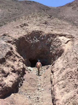
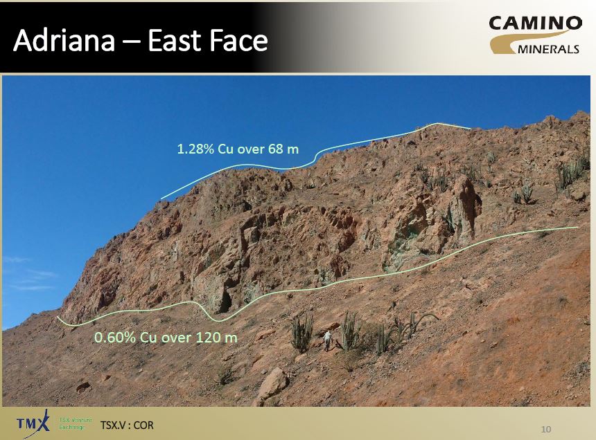
When we look at the presentation they show us some photos of some old workings.


They look to be nearly vertical, indicating that this how the mineralization occurs at Adriana.If the deep mineralization hit in hole 002 is vertical, then that zone may only by ~ 40m thick.


I think That Camino need to rethink their drilling strategy! They need to get some diamond rigs up there to answer questions on controls and size of mineralization. Continuing to drill RC-holes will start to reduce the value the company obtained from hole 002.

I've created a quick model of the drill-holes with their sections, so you can see how all the holes relate (link).

Look at how the Magnetite rich zone changes between sections...

Trenching results

Hello, FAG here.  Camino have given us some nice photos of some green-stained rocks in the Atacama.

Clouds!!!
Azurite skies...
and some photos of some old workings

Mein Mine

I've annotated the mine photo to show how you can get Maximum Impact (tm) results from trenches.


We have 2 trenches

  • Trench 1 - running parallel/along with the copper zone
  • Trench 2 - running perpendicular to the copper zone
Which will give the 'best result' for your press release?
  • Trench 1 = 30m @ ~1% Cu
  • Trench 2 = 3-5m @ 0.6-1% Cu
The question you need to ask is:


Mineralization

This was covered in the IKN post, so I've just included a image of a simplified mineralization zoning in a copper deposit


So, the upper zone is primarily oxide material, it may have some native copper and copper wad that is insoluble accounting for the 25% of the material that isn't acid soluble.

However, the lower zone is high-grade, contains only 25% soluble material, I wonder if this hole hit the enriched zone and we have a lot of Chalcocite.