Summary
- Good
- Great result from hole CHR-002
- but, we have grade smearing, outside the >2% zone, it drops off to 0.84% Cu, still good, but could be marginal for an open pit operation
- Small, near surface oxide zone
- Some other interesting targets to be tested around the property
- Bad
- It was a shame that they went with cheapo RC drilling option as it meant:
- Hole 002 terminated in good copper mineralization
- Holes 004 and 005 couldn't reach the extension of this zone.
- Typical grade 'expansion' - the high grade (>1% Cu) is found in narrow zones surrounded by low grade (0.2-0.3% Cu).
- Trench samples look good, but I'm skeptical of trench sampling as:
- remember - you can bias them by sampling along a mineralized structure rather than sampling across it - the FAG will explain how you can 'improve' your trench results
Is water, or the lack of, going to be an issue?
There are advantages and disadvantages with using an RC rig:
- Advantages
- Quicker - drill 200-300m per day compared to 50-100m for a diamond drill
- A lot cheaper - ~50% of the cost (or even cheaper) of a diamond rig.
- Doesn't need water - very useful in the Atacama desert
- Disadvantages
- Lower quality geological information
- greater deviation - the holes drilled by Camino started at 45 or 50 degress, but steepened to almost 80 degrees at the end of the hole.
- if you see any company not-surveying RC holes, that is a good sign that they don't know what they are doing and that the data from these holes are suspect as they can't accurately tell you where the mineralization is located.
- bigger visual impact
- require more site preparation - wider roads, larger pads
- generally limited depth - ~300m depth is generally the deepest you can drill with RC
- can have grade issues - smearing of grade, especially at the water table
TL:DR: They started off good, but by using the wrong equipment, they have are not maximising the value they are getting from teh drilling (unless drilling magnetite-rich zones is the objective).
Geology Wank
Hole CHR-002, very good zone, but as the hole stoped in mineralization we don't know how wide it will be.Follow-up holes 003, 004 and 005 intersected the upper copper oxide zone, but due to hole deviation, which is common in RC drilling, they all steepened and didn't reach the target. The irony is, this deviation was seen in holes 001 and 002 and I would have expected Camino to have modified the program accordingly, as they showed us that there was a very high probability that holes 004 and 005 would have steepened (go more vertical) and not hit the copper zone.
I'll explain it visually, I prepared this image form the original press release

- Red line = planned hole trace (i.e. where they wanted the hole to go)
- Colored line = actual trace of the drill-holes
- Difference between these lines = the deviation
- we can see that as the hole gets deeper, the hole steepens (becomes more vertical)
- We can also see that the holes can only be drilled to around 300m - this is as far as this RC rig is able to drill at this project.
- Magenta line = what I think hole CMR-005 will do - it will hit the upper zone (my guess ~20m @ 0.6% Cu) and not reach the copper zone.
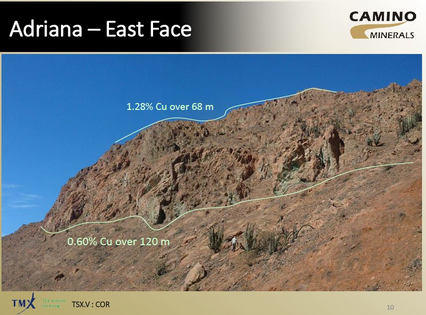
This is from the latest presentation
Look how much blue (0.1-0.3% Cu) is included in that 44m zone grading 0.86% Cu!
So you can see how much the holes are bending by (up to 20 degrees), and that makes it hard for the company to hit the planned targets, which is the reason why holes 004 and 005 missed.
You also need to think about the how the mineralization occurs, is it:

They look to be nearly vertical, indicating that this how the mineralization occurs at Adriana.If the deep mineralization hit in hole 002 is vertical, then that zone may only by ~ 40m thick.

I think That Camino need to rethink their drilling strategy! They need to get some diamond rigs up there to answer questions on controls and size of mineralization. Continuing to drill RC-holes will start to reduce the value the company obtained from hole 002.
I've created a quick model of the drill-holes with their sections, so you can see how all the holes relate (link).
Look at how the Magnetite rich zone changes between sections...
and some photos of some old workings
I've annotated the mine photo to show how you can get Maximum Impact (tm) results from trenches.
We have 2 trenches

 |
| bendy drillholes |
 |
| so that makes them 0 from 3 |
So you can see how much the holes are bending by (up to 20 degrees), and that makes it hard for the company to hit the planned targets, which is the reason why holes 004 and 005 missed.
You also need to think about the how the mineralization occurs, is it:
- flat lying bodies
- Steeply dipping narrow zones
- large stocks

They look to be nearly vertical, indicating that this how the mineralization occurs at Adriana.If the deep mineralization hit in hole 002 is vertical, then that zone may only by ~ 40m thick.

I think That Camino need to rethink their drilling strategy! They need to get some diamond rigs up there to answer questions on controls and size of mineralization. Continuing to drill RC-holes will start to reduce the value the company obtained from hole 002.
I've created a quick model of the drill-holes with their sections, so you can see how all the holes relate (link).
Look at how the Magnetite rich zone changes between sections...
Trenching results
Hello, FAG here. Camino have given us some nice photos of some green-stained rocks in the Atacama. |
| Clouds!!! |
 |
| Azurite skies... |
 |
| Mein Mine |
I've annotated the mine photo to show how you can get Maximum Impact (tm) results from trenches.
 |
- Trench 1 - running parallel/along with the copper zone
- Trench 2 - running perpendicular to the copper zone
Which will give the 'best result' for your press release?
- Trench 1 = 30m @ ~1% Cu
- Trench 2 = 3-5m @ 0.6-1% Cu
The question you need to ask is:

Mineralization
This was covered in the IKN post, so I've just included a image of a simplified mineralization zoning in a copper deposit

So, the upper zone is primarily oxide material, it may have some native copper and copper wad that is insoluble accounting for the 25% of the material that isn't acid soluble.
However, the lower zone is high-grade, contains only 25% soluble material, I wonder if this hole hit the enriched zone and we have a lot of Chalcocite.
In the April 25 PR they state the remaining holes in 'Phase 1' will be core drilled. Hole 5 suggests orientation at least in the vicinity is sub-horizontal. I don't know the exact layout at Mina Justa but the similarities to Camino's project are certainly there. I also think the orientation will end up sub-horizontal vs. vertical. One problem I see is a potential plunge into the hillside which might mean deeper and deeper holes being needed to delineate the width.
ReplyDeleteHello Tom,
DeleteMina Justa is sub-horizontal, but have a couple of issues. The mineralization crosses over the property boundary into a neighboring iron mine, and there is feck all water.
It is so hard with a single hole. However, if the mineralization was sub-horizontal, they should have hit it with holes 4 and definitely hole 5. The surface prospects suggest that the mineralization is relatively steep.
In short - we need the diamond rig there. However, as this is a very dry area, there could be some interesting logistical questions to shipping in water by water truck.
and a follow on - looking ta the plan map overlain on the sat photo, and the photo of the drill rig. the topography drops off to the SE, so maybe (if the mineralization is sub-horizontal) it outcrops or could be drilled further down the slope?
DeleteThe mag and other geophysics suggest the thing plunges to the SW-W which might be into some hillsides, not necessarily helpful. I think they are still some ways form figure out the primary orientation.
DeleteHello Tom,
DeleteI'm hoping that some more diamond drilling will help them determine the orientation of the mineralization. I was surprised that they didn't drill the IP anomaly that they show us in the presentation, but I'm guessing that they may not be able to drill there for either:
1. Environmental - there is a 50m buffer around drainages
2. community - that drainage/spur could mark a community boundary and Camino may not have permission to drill there
3. Permitting - they did as small a permit area as possible (to get it quickly) and may need to modify it.
I'm hoping that future diamond holes give some good results and better help to understand the mineralization at Adriana.
Mina Justa crossing to Shougang iron mine property and its ore body has a sub-horizontal geometry? Where this comes from?
ReplyDeleteHello Miro,
DeleteI know the Mina Justa property. The mineralization is in gently dipping sub-horizontal bodies, that cross onto the adjacent Iron project. This is the likely orientation for the copper bodies at Adriana, but the historic workings show a more vertical orientation. Maybe they were mining Cu Ox in high-angle faults.
Hi Angry. Would be nice to read an update from you following the September to early November news released.
ReplyDelete