Showing posts with label geology. Show all posts

Friday, January 20, 2017

Bulk Density - an overlooked part of a resource calculation

I touched on this as part of my series of posts on the Hermosa project, and I wanted to expand.

Tonnes = volume x bulk density

Companies spend a lot of time calculating the grade and the volume, but as we saw with Taylor deposit there have been a few cock-ups cause by not getting the actually density of the different rock that contains the metals you want.

Bulk Density is also specific gravity - this is the mass of a rock within a certain volume and is normally expressed as grams per cubic centimeter or tonnes per cubic meter.

For reference water has an SG of 1 which means:

  • 1 cm3 of water weights 1 gram, 
  • 1 m3 of water weights 1,000,000 grams or 1 tonne.

SG of different rocks - link
SG of different sulfide minerals - link

The SG value for a rock if affected by porosity (microscopic spaces between the grains), fracturing (faulting), weathering (removing minerals or altering them into 'lighter' clay minerals).

Why is this an issue? Here are a series of long sections from Galway's Estrades project in Canada. These images came from the November 2006 Technical reported prepared by Scott Wilson RPA for Cogitore Resources Inc.

Here are a series of long sections showing the distribution of each major economic element (there are sections for gold and silver but they constitute a very small part of the rock and won't impact the bulk destiny by any significant amount).

Zinc

Copper
Lead

Bulk Density
Here is an annotated version where I have drawn on (badly) the >1% Pb, Zn and Cu grade contours.


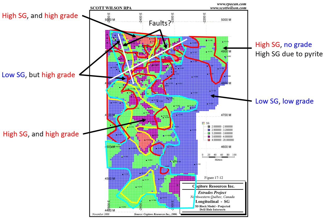
You can see that in general there is a reasonable correlation between grade (total sulfide content) and SG, but it isn't perfect. We can see that the Bulk Density (SG) varies from less than 2 g/cm3 (blue) >4 g/cm3 (a 100% difference). So you can see the problems that could be caused if you use a single bulk density value for a rock type or ore zone, or use an arbitrary values. 

Most companies have adopted the "take lots of samples" approach as collected bulk density measurements is cheap and quick and will allow you to accurately model the changes in the bulk density within a deposit.

However, if you see a company using single or average bulk density values (or mathematical formulas) in their resource calculations, it should make you stop and think for a moment as there have been some major and costly failures where companies haven't used the correct SG value.

One interesting technical question to ask - specifically directed towards Hermosa - is what is the correlation between sulfur assays and bulk density?


Tuesday, June 21, 2016

Hot Maden - Turkish delight or terror

Mariana Resources have been announcing some great intercepts from their Hot Maden project in Turkey, so I was intrigued to see a) how good the project really is and; b) what potential is there to expand the resources and c) are there more high grade deposits to be found?

Summary (the TL:DR Version)

  • Initial resources outlined a small, but very high grade deposit
    • Majority (>60%) of the Gold is in a small, ultra-high grade zone.
  • Follow-up drilling appears to have closed off the deposit.
    • Recently announced intercept in hole 053 (40m @ 9g/t Au) needs follow-up
  • Exploration around deposit hints at additional 
  • Drilling has focused in an 800m long core of a 4km regional alteration trend.
    • good potential to find additional deposits
  • Is there a second, unexplored alteration zone cropping out in the NW of the project?


Here are the initial resources (Sept 2015)

If you look at the table, 60% of the gold is in the Main Zone UHG (Ultra High Grade). Accurately defining this zone will be key for the deposit.

The initial resources were defined from just 17 drill-holes, and since then Mariana and their JV partner Lidya. it has a central A-Cu zone with a Zn rich halo.

Gold: Red arrow = trend of high grade zone

Copper: Red Arrow = trend of high grade zone

Zinc: moderate/low grade zone halo around the Cu-Au core

If you want to look at this data in 3D, you can download the Leapfrog viewer files from here (link).


When we bring in all the data from all 53 drill-holes that have been announced:


Comparison of my 1 g/t Au grade shells from all DH (blue) and the first 17 DH (red)


 The majority of the new drilling has focused on:
  • Infill = better defining the high grade zone
  • Resource expansion.
    • Trying to link the 2 resource areas
    • Exploring for the extension of mineralisation along strike and to depth in the main zone
The drilling has been partially successful. The high grade zone is now better defined and from initial review appears to be similar sized or slightly larger than initially calculated. There are several high grade intercepts (e.g. DH 052 and 053) that need followed up.
I would guess that in an updated resource we would see a moderate increase as drilling has essentially defined mineralisation limits, and outside of this most drill-holes have hit narrow zones of moderate grade within a low-grade halo.

Again, you can find all this data in 3D here (link).


But it isn't all doom and gloom, when you take all of the data and put it all together, I pulled all the soil maps from the technical report, the sections and satellite imagery from Google Earth, the project area looks very exciting.

Drilling has focused on exploring the large (900m x 250m) gold, copper and Zinc soil anomalies, and has explored them systematically with great results.

Current resources = black outline; drill-holes = white circles.
The area to the south looks very interesting!

 When we look regionally, we see that drilling (and maybe exploration in general)  has only focused on a small (800m) portion of a much larger alteration zone.


This is understandable, this is where most of the historic mining has occurred, but there may be multiple deposits along this trend and it would be nice to see Mariana/Lidya exploring the rest of this trend. In Google Earth there appears to be a second, smaller alteration zone to the NW of the main trend, could there be anything interesting here?

Looking at the topography, maybe a regional stream sediment sampling program will identify areas of interest for future exploration?

The 3D view of the regional and drilling data can be found here (link)


Thursday, April 28, 2016

The amazing things you can do with 43-101 reports

I'm a geologist, and one of the most important aspects of my jobs is reviewing projects to understand their potential.

I love the fact that companies listed on the Canadian exchanges need to file all of the press releases, financial statements and technical reports on Sedar (link). This gives me access to massive amount of data, but sometimes it is hard to understand and to really see what is going on.

What I've been trying to do is take as much of the information from a technical report, supplemented by publicly releases data (press releases, presentations and quarterly reports) to see if I can create a simple, easy to understand summary of a property.

I'm also going to release leapfrog viewer files of this data so you can download and view it, to see what I've done and make any suggestions and observations on what is being presented.

You can also send me a project to work on if you like.