Summary
- Majority of the new assay data is from infill holes (7 of 10 holes) that intersected similar grades to surrounding holes
- We see a lot of grade inflation - thick zones are in reality a much narrower high-grade zone, surrounded by low grade rocks (e.g. hole 403)
- NW DH looking for the continuation of Taylor weren't anything special:
- Deep, narrow, low grade CRD mineralization - it looks like the system is dying out in this direction
- Shallow, high-grade vein mineralization - maybe this should be their focus for future drilling in this area?
- Permitting - Arizona Mining are pushing shit uphill with this project, mate.
Technical junk
Here is the accompanying map for the first release, with my annotations to help you understand the maps a bit better. |
| Taylor deposit drilling - Jan 17th PR (Source: Arizona Mining website) |
 |
| Red hatched areas = can't drill here |
 |
| Green shaded areas = public land, unshaded areas are private land. Taylor deposit is at the bottom of the image. |
Not many places for picking and poking with drilling
Arizona mining did want to drill in the public land, but unfortunately their recent application for 8 holes was cancelled (link), and they have another permit for 5-6 exploration holes that are on-hold.

You can download the enture permit application and maps from here (link).
A big thanks to LM for that info.
The Question is this:
Do Arizona management need to inform their shareholders and the market that their permits to explore on public land have been cancelled? Is this of material importance to the project?
I feel it is, but then again, I'm a geologist and know nothing
I feel it is, but then again, I'm a geologist and know nothing
As I have mentioned before, if they cannot get a permit to drill on public land, how can they believe that they can obtain the numerous permits to build and operate a mine, where potentially a large portion of the infrastructure, tailings and mine dumps will probably be (like for the Central Deposit) on public land?
This is going to make the PFS study very interesting. Will they:
- Do a cop out - not have any plans for the surface infrastructure
- Do a Central - have plans for the surface infrastructure in the optimal locations (i.e. a large portion on public land) where you know they can't do anything
- Try and squeeze everything into the private
I'm 50:50 between (2) and (3).
Geology Crap
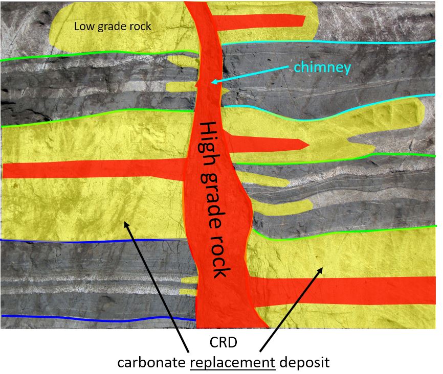
Here is a long section through an idealized CRD deposit (source - Pasinex Adana deposit (link) and Dr. Peter Megaw)
and here is an annotated long section through Taylor

It looks very similar to Peter's model, which is good, and you can see that there are 3 distinct styles of mineralization:
- CRD horizons - black dashed lines - these are dipping to the left (NW), and individual horizons are very extensive and have been drilled over lengths of >1km with relatively consistent mineralization. These are a nice steak.
- Chimneys - mineralization restricted to narrow (100m x 200m) vertical zones, with sharp grade contacts (i.e. outside of the chimney grade is very low). Think of these as a bottle of wine - all the good stuff is inside.
- Veins - narrow, very high grade vertical structures. Think of these are those thin sheets of chocolate that you get stuck in desserts in fancy restaurants. They are great, but there is never quite enough.
Thee zones are very different (grade, style, orientation) and if you use a 'generic' control (i.e. assume that all the mineralization is horizontal), you may be over or underestimating the amount of mineralization in chimney zones. This is where infill drilling really helps to define the extents to mineralization.


Source (link) - Photo of Fault with Fault Breccia by James S. John - I know it is the wrong rock type (Taylor is in limestone), but it was such a good photo showing bedding and faulting.
- Ante Mineralum

- Post Mineralum
Source (link) - Photo of Fault with Fault Breccia by James S. John - I know it is the wrong rock type (Taylor is in limestone), but it was such a good photo showing bedding and faulting.
The Press Releases
This is where the holes were drilled
 |
| Blue = Jan 17th PR holes; red = Jan 26th PR holes |
19th Jan - assays released from 7 drill-holes.
- 4 holes (HDS-388, 397, 398 and 400) were drilling into the core of the Taylor deposit
- These are infill holes (i.e. drilling between earlier holes that hit mineralization)
- Low risk drill-holes as the earlier holes surrounding them give you a good idea of what you will hit.
- 3 holes (HDS-384, 390 and 392) looking for the NW continuation of the Taylor horizons.
- These are (relatively) high-risk holes, as the main Taylor horizon is very deep (>1000m) here.
- Deep = expensive drilling.
- Results were poor, the CRD zones are thin and low-grade. However, the holes did hit some shallow, high-grade vein mineralization.
26th Jan - assays from 3 drill-holes.
- All holes were infill holes designed to better understand the Taylor deposit mineralization and to convert inferred into indicated resources. They won't have much impact on the overall tonnage of the deposit.
- Holes intersected narrow high-grade zones, surrounded by lower grade mineralization - this could have an impact on reducing the overall grade and tonnes of the deposit.
NW Holes
Here is a section through the deposit. I've added scale bars so you can see how deep AZ are drilling.Holes 390 and 392 hit mineralization at ~1100-1200m depth (it is probably costing them at least $200K/hole to drill to that depth).
 |
| CRD zones = red lines. |
We can Also see that the 2 main Taylor CRD zones stop between holes 401 and 392. So it looks like resource expansion to the NW is limited as best. I can;t see them drilling more holes in this area, unless they are going to focus on the shallow, high grade veins.
Central Zone
Here we see the chimney effect, in the chimneys we get much thicker and higher grade material, and when you look at the results in more detail, we actually see that these thick zones are really several, narrower high grade (>5% Pb) zones surrounded by marginal grade rocks. |
| Please note - I've used lead to highlight the high-grade zones |
- Cram as many holes into that area as possible that may significantly reduce change the size of this high grade zone, but would give some spiffy PR headlines
- Treat this area as a "Zone of Avoidance" - if we don't touch it, we won't break it approach - this leaves a nice chunk of inferred resources but preserves its virtue and make sure it stays nice and large (and relatively undrilled).
So, for me, I think Hermosa is a large base metal resource, but no more. The local communities have successfully prevented any mining or exploration activities from being conducted on public land (not just for Arizona Mining but for several other companies as well), and I can guarantee that the PFS and FS due in Q1 and the end of 2017, will show how robust the economics of the project are, but if you can't get permits, the zinc, lead and silver are going to stay in the ground.
3D model can be found here (link)
This area is a dead zone for mining. ASARCO tried to get a permit for Hermosa/Central in the 1980s(?) and failed. Well, the PFS is due in the next 6 weeks - it will be an interesting read
ReplyDeleteThe drilling application was actually cancelled by the company itself, because the Forest Service indicated they would require at minimum an Environmental Assessment which is like an 18 month process. And in the end apparently the application had already been downsized to just 2 drill platforms totaling less than an acre of disturbance, which is tiny in the scheme of exploration on forest land. So instead, the company withdrew the application and is now supposedly planning a much larger drill program on the public land to be announced sometime in 2017, hoping I guess that under Trump the Forest Service will ignore the established molasses-pace process and fast-track approve the new drilling to commence shortly over the objections of the local majority. In the meanwhile, said locals continue coming up with new material to defeat mining in this area including the recent appearance of several jaguars including possibly a female, which are the first ones to have been observed in the U.S. in decades. So best case is still about 10 years for permitting. A good example might be the Montenore and Rock Creek projects in Montana (both now owned by Hecla) which are about 15 years into the process. Of course the most direct comparable is Rosemont which has dragged along in final permitting purgatory for a staggering 6 years.
ReplyDeleteMr. Szabo, you might be wrong on the opposition, might be the objections of a local minority.Many long term and younger residents are more interested in growth and jobs than a quiet environment. Jaquars were spotted about one hundred miles away, not really a local issue.
DeleteMr. Szabo, you might be wrong on the opposition, might be the objections of a local minority.Many long term and younger residents are more interested in growth and jobs than a quiet environment. Jaquars were spotted about one hundred miles away, not really a local issue.
Delete