Showing posts with label Porphyry. Show all posts

Saturday, September 22, 2018

Cascabel - after a metric f-tonne of drilling

DISCLOSURE: I own shares in SolGold

Drill results have been spewing from Sol Gold this year and I've been too lazy to bother updating my model, but as people have been irritating me, I've decided to undertake the herculean task of bring in more than 135Km of DH data into some sort of semblance.

I've probably failed, but the 3D model looks pretty (link), and that is the only thing that is important.

Cop-out section: A lot of drill hole information (e.g. final hole lengths etc.) wasn't included in the press releases and on the maps accompanying the recent press releases there are so many holes.

like a orgy of rabid worms

You can see that there are holes over holes over holes, to such an extent that even Sol Gold aren't able to accurately label them!

The deposit with 2 holes with the same name

Basically, what I'm trying to say is, take my results with a pinch of salt, I've tried to do the best I can, but I don't know how accurate my model is, so beware.

Before I started compiling the data, I was concerned that the majority of the drilling was focusing on the high-grade core initially defined in 2017 and that all Sol Gold will have done is simply moved a chunk of the Inferred Resources into the Indicated category, which would be regarded as a bit of a failure after drilling so many holes and spending so much money.

In addition, when you pull apart the assays, we see time and time again, that in reality the >1% CuEq mineralization is restricted to quite narrow zones, surrounded by sub-economic (<1%CuEq) mineralization.

Back in January (link) I updated my original model to try and replicate the official SRK resources, and here is my latest version that (tries and probably fails) incorporates as much of the data as possible.

I've been a bit handicapped by the fact that Sol Gold haven't released assays for every hole drilled, just summary results from the best ones.

Here it is:


Table from January 2018 post


The changes are moderate:

  • Specific Gravity - 2.77, taken from the technical report - 
  • Global resources (>0.3% CuEQ) increased by ~37%
  • High-grade resources (>0.9% CuEq) increased by just 12%
Overall, a bit disappointing.

Just a quick question for people in the mining bizz, this paragraph caught my eye in the Alpala technical report


US$5M is a lot for a PEA, isn't it?

Saturday, May 12, 2018

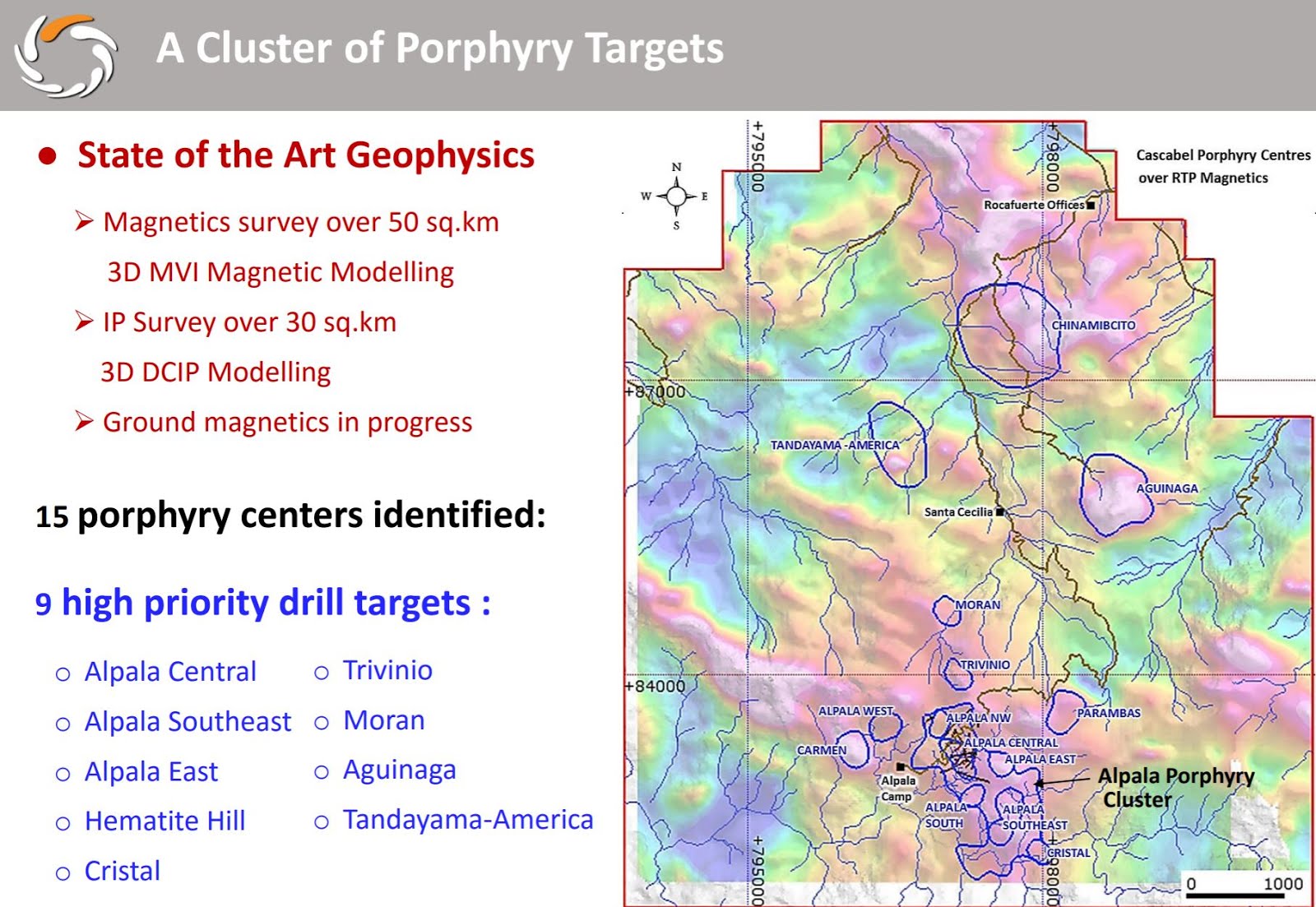
SolGold - Aguinaga - an initial review

DISCLOSURE - I OWN SHARES IN SOLGOLD

At last, some drilling away from Alpala (link)! SolGold have finished the first hole at Aguinaga (link). Unfortunately, I don't think the results will be very special, I'm guessing that they come in around the 0.4-0.6% CuEq level.

This is what we are told about the first hole:

Translation - feck, we hope it gets better at depth

It is very early days (1 hole), but the concern is that the Aguinaga Porphyry appears to be small and low grade. We see that the 'strongly mineralized porphyry' was intersected ~300m vertically below the discover which limits its extent to the NW and being just ~250m wide (horizontally) limits is potential to become huge. Bollocks!


The core photos from hole 01 look a bit anemic. They look similar to the low grade holes at Alpala, that typically ran around 0.5% CuEq (typically 0.3% Cu and 0.1-0.2 g/t Au)


At Alpala, if a drill hole was bulging with copper sulfides, Sol Gold would rush out an early release with partial results. They haven't done the same here, we get some confirmation of lack of optimism in the hole by the company in this statement.


i.e. the core looks crap, we're leaving the rigs to drill the good stuff

However, if we work back we know that the drilling would have passed through the 'well mineralized' porphyry around the start of April, so we should expect the results to be released before the end of the month if they are good enough to stand on their own. If they are below expectations, they'll be buried in a PR with a load of intercepts from Alpala.

I've created a separate Leapfrog project for Aguinaga, you can get the viewer file from here (link)


Monday, April 9, 2018

Timok - the Lower zone - part II

Deep porphyries, what more could a geologist want. Several weeks ago I asked a simple question (link):

Will it be good or bad!!
We have some more results from Lower Timok (link) that put a few holes into this area.


They also drilled a few holes in the core of the deposit, and as they also announced that they'll have an initial resource estimate by mid-2018, i decided to have a go, and so here is one of my wonderfully pathetic resource guesstimates (TM). You can get the Updated LF views from here (link)

Quite big!
UPDATE - I used relatively crude grade shells for the CuEq calculations (multiples of 0.25% CuEq), I've updated this table using a 0.2% CuEq scale (so 0.2, 0.4, 0.6 etc).


This helps to smooth the data and prevents the final tonnages and grades being skewed.

In the last post (link) I used a 400m base range, and commented that this may be to large for resource calculation, so I've been conservative and reduced it to 300m, which I'm more comfortable with using as it is a reasonable value to define inferred resource.

Remember - using a very big search ranges is a good way to inflate resources in all deposits. In porphyries - anything above 300m is starting to look unrealistic, and is a good thing to check. In exploration, I like to use twice the average drill-hole spacing as a first pass.

It is looking quite robust,  shame it is at ~800m depth, but the numbers are still good enough to support a large underground operation, especially as they'll be making oodles of cash from the upper deposit.

Exploration upside

I also want to see if it can get bigger, from just a giant deposit to a massive one. With the CAPEX required to develop a large underground mine, Nevsun will want something that will support a 20+ year mine life. Again, if you see a project with a <10 year mine life, unless it has exceptional grades, it is best to avoid. It may pay back the CAPEX, but you want something that will generate enough revenues to develop the next project.

Here we have good news and bad news. Looking at a few sections through it

Yellow = long section location
cyan = cross section locations

Long Section


Damn, my great idea was crap. The could of holes drilled to look for the SE (left) continuation hit virtually nothing, and to the NW, the grades are decent, but we are getting very very deep (almost 2km).


SE Cross section


We can see that to the NE mineralization is closed off, but maybe below the Upper zone, we could see more mineralization. It is relatively shallow (~900m depth). I've doodled on what I think is the high temperature core, where normally there isn't much mineralization, but potentially it could mean that they only half of the system has been drilled. It would be nice to see some section showing Moly and vein-type distributions (*cough* *cough*).

NW Cross section


We're much deeper, but the mineralization is open to the NE and SW.

So there appears to be some obvious areas to expand the mineralization. however, I would like to see Nevsun start to use directional drilling or drilling wedge holes (similar to SolGold at Alpala).


Monday, February 26, 2018

Alacran - Sting of the Scorpion

PDAC season is in full flow, and lots of companies are pushing out press releases to telling us that they are great, everything is going super-well and please don't ignore us and sell our stock as we have no real news.

One of my favorite pig in lipstick press releases was from Cordoba Minerals (link), not only announcing an updated resource for Alacran, but telling us that theyz got cobalt az well, m8.

Fuk uz Forst Cobalt


We'll ignore that and look at the resources.

Original, Jan 2017 resources

hard to read, but resources calculated at $1300/oz Au and $2.50/lb Cu


New and improved resources:

@ $1400/oz Au and $3.15/lb Cu

I liked the interesting metal prices used, Cordoba was a little generous with the gold price, but why don't we do some maths and see how the project has grown with another successful year of exploration.

I mean, look at that, they increased resources by ~27%. That deserves a good hug and a nice pat on the back, we'll ignore the fact that as the tonnes have increased, those nasty little copper and gold atoms have been efficient with their New Year resolutions. Those pricks have been on a diet!


and given the deposit a stunningly unimpressive negative increase in contained metals.


  • Copper 
    • Grades dropped by 22%
    • contained metal stayed essentially the same
  • Gold
    • Grades dropped by 32%
    • contained gold dropped by 15% or 94,000 ounces
So, basically you've made Alacran worse. Well done!


Wednesday, December 13, 2017

Timok - the Lower zone

Some updates to correct for some inaccuracies, and to update the resource table to include additional information.

And now for something completely different...

I wasn't expecting the Spanish Inquisition over Nickel Mountain.


Back to reality, Nevsun have been releasing some great results from the Lower Timok Zone (link), we can see on the accompanying plan maps and sections that this zone is large, but deep.

Figure 1 - The Plan Map

You can clearly see the footprint of the Lower Zone, with approximate dimensions of 1.5km wide by ~1km. To the south, we can see the smaller, but very high-grade Upper Zone.

Figure 2: The Section....
So we can see that the Lower zone extends from 800m to ~2000m below surface. I've added some annotations.

Figure 3: The horse chestnut---hurrah!

We can see that there is potential to extend the known mineralization to depth, and maybe to the West, where no deep drilling appear to have has occurred beneath the Upper Zone.

However, I commented in previous posts that one of the problems at Alpala was its depth. The initial drilling didn't appear to outline a resource that was sufficiently large or high grade to support the development of a stand alone, large-scale, underground operation. Do we have the same issues at Lower Timok?

I've compiled as much data that I can find for Lower Timok, and I've also included the recent (2016-17) drilling from the high-grade Upper Zone as well, just to allow you to compare their location, depths and relative sizes.

You can download the 3D viewer file from here (link).

The first step was to evaluate the size and grade for the Lower Zone. I created a series of grade shells for Au, Cu and CuEq (I used Nevsun's CuEq calculation 1g/t = 0.7% Cu). These are all included in the Leapfrog viewer file as well as all the sections from the December 4th PR.

Disclosure:

  • I haven't factored in any recoveries for Au and Cu when calculating the CuEq values
  • I have not been able to find any assays for holes TC150073 and TC160073B
    • These holes go through the center of the Lower Zone, and therefore my Bad Estimates (TM) are likely to be slightly low. I'll keep looking for this data,and when I find it, i'll update the model.

Here are the assumptions I used to create the grade shells in Leapfrog Geo:
  • Base range = 400m - the holes are widely spaced (they may even be too wide to determine an initial inferred resource)
  • Interpolant = Spheroidal
  • Drift = None
  • Specific Gravity = 2.7 (assuming the rocks are granitic in composition with minor sulfides)
  • I applied a filter so that the Upper Zone drill-holes would not be used to create the various grade shells.
Here is an updated "officially bad estimates" (TM) for the Lower Zone:


Just a couple of observations:
  • There appears to be a lot of contained metal at Lower Timok, 
    • the majority is too low grade for an underground operation and should be considered as 'mathematical' resources.
  • The overall gold content is low
    • Will the concentrates contain payable amounts of gold?
At the bottom of each table I've given a tonnage and grade at various cut-off limits. I'm going to use a 1% CuEq in the following section.

If we compare my 'resource' CuEq grades and plot them against the Macquarie Reseach report on large-scale underground porphyry projects.


Red dashed line = average grade for Lower Timok (using a 1% CuEq cut-off) = 1.28% CuEq
Blue star = cut-off value for a underground block cave operation for a brownfield operation
Green star = cut-off value for a greenfield block cave operation


Lower Timok grade vs other Block cave operations/development projects 
We can see that Lower Timok isn't quite good as a stand alone greenfield development project, but as it is adjacent to Upper Timok, with a quite robust PEA, we can considered Lower Timok to be a brownfield project, and now we see that it is high enough grade to pass the Brownfield hurdle grade.

However it isn't quite as simple as that. If we look at the recently released PEA from the Upper zone (link), and we are told:

  • Initial Capex ~$US615M
  • Mine Life ~15 yeears
  • Mining rate ~8,900 tonnes per day
  • NAV = $1.5B
If we compare this to Stage 1 for Wafi-Golpu project (link), which I think could be a good analogue to the hypothetical costs to develop Lower Timok.


You can see that I've highlighted some important values.

  • Initial Capex = US$2.6B
  • Ore mined and milled = 149Mt (approximately similar to Lower Timok)
  • Mine life = 28 years or approximately 15,000 tonnes per day
  • First ore milled = project development time line = 60 months or 5 years
  • Steady-state production = time taken to reach full capacity = 90 months or 7.5 years

So, if Nevsun were looking to develop the and mine the Lower Zone, it will require significant additional CAPEX, larger milling and surface facilities (tailings and waste dumps) than proposed for the Upper Zone mine. This means that Lower Zone is a half-greenfield half-brownfield project - I'll call it an Olive Project, and that Nevsun have a couple of options:

  1. Mine the Upper Zone, make lots of money and 'keep' the lower zone on their books as a large resource, but don't develop it.
  2. Mine the Upper Zone, and after 5 years start the permitting and development of the Lower Zone, and slowly increase the size of the surface facilities (Mill, tailings, waste dumps etc.), and bring the Lower Zone into production towards the end of mining the Upper Zone.

This is my hypothetical scenario for Lower Timok

  • Initial Capex = US$1.5B (the topography is significantly easier around Timok so less earth moving, and assuming that they will use and expand on the Upper Timok surface facilities)
  • Ore mined and milled = 200Mt
  • Mining rate = ~15,000 tonnes per day
    • Need to expand surface milling facilities by 5000-6000 tonnes per day
    • Expand the flotation circuits
      • I don't know how feasible this is, but it is something that Nevsun may need to consider to include as part of the development of the Upper Timok project, especially permits for expansion of tailings facilities as these may taken several years to obtain.
  • Development period = 3-5 years
  • Time taken to reach full capacity = 5-7 years (including development period).
    • The idea is that the project would need to be developed while the Upper Zone is being mined and then Nevsun can extend the infrastructure from the Upper Zone development into the Lower Zone.
At the moment, there aren't a huge number of drill-holes into Lower Timok, and the drill hole density is still quite low (approx. 300-400m between drill-holes), but the initial data shows a robust porphyry system, that is open in a number of directions.

The initial (i.e. very bad) review suggests that it could support a medium-sized underground operation, but its development is dependent on the economics of the Upper Zone and how Nevsun/Freeport decide to develop the Lower Zone.

Will Nevsun just focus on the Upper Zone or will they factor in the development of the Lower Zone into their future decisions for the project? 

For investors, the upside could be, that if the Lower zones becomes significantly larger (e.g.>500Mt at similar CuEq grades), would Freeport step in and take out Nevsun to consolidate their ownership of a large porphyry Cu-Au deposit not owned by a major mining company?


Wednesday, November 8, 2017

The Valleys are full of crappy copper deposits......

Vizcachitas, the "Largest Independent Copper Project in the Americas" we are told by Los Andes. All that is missing is "undeveloped", to really tell us how great the project is!


All projects are great from afar.....

Summary

  • A large, but low grade resource and with a very small 'high-grade' zone. 
  • Good recoveries, but minimal by-product contribution
    • >95% for Copper
    • 55-70% for Mo
  • Expansion of near surface resources looks limited, but hole V2017-10 did intersect some interesting grades at depth.
  • Bad geography, located in the bottom of a relatively steep valley, this could have big implications on strip ratios as minor changes in pit slope angle may mean moving very large amounts of waste rock.
  • 2014 PEA show that a small (40 ktpd) operation is very marginal and that very minor (5%) increases in CAPEX or OPEX will have a major impact on the project economics.
  • So, Vizcachitas is too small, too low grade with marginal economics. As they say, can't make a silk purse out of a sow's ear.
*resources haven't been updated to include the 2015-17 drilling.

Geo-babble


DISCLOSURE: I've compiled as much of the information as possible that is in the public domain. However, I've had to estimate the angle of dip, and I'm sure that I've only been able to find summarized assay data for ~65% of the 'deposit'.

You can download the Leapfrog project from here (link)

Resources


The first area I wanted to look at is the quality of the resources, especially the tonnage at high, medium and low cut-off grades.

lots of high-grade, just not in the resources....
So we can see that the majority of the deposit is very low grade, and a small part (only 19%) of the indicated resources scraping over 0.5% Cu.

However, the recent drill results have been interesting (link) with some (reported) thick, reasonable grade intercepts, but we need to check where these holes have been drilled (link).


You can quickly see that the majority of the new holes are clustered in areas of known mineralization, with a couple, including hole V2017-10 drilled to the north.

In the image below I have created a >0.4% Cu grade shell for the project using (left) pre-2015 drilling and (right) all drilling. To see how the resource has changed.

changes circled in red
There is a new area to the north, centered on hole V2017-10 and some minor expansion around the edges of the known mineralization. There are no new high -grade zones, and when you look at it, the >0.4% Cu grade shell is quite poddy and doesn't form a nice solid consistent zone with a high-grade core.

Here are some sections, you'll notice that the >0.4% Cu zone doesn't extend to great depths.

Section 2800N

Section 3400N

Section 3900N

These zones aren't very thick, but we can see that the mineralization in Hole V2017-10 is open in several directions, but is deep, all other mineralized zones appear to have been close off or are very narrow, so unfortunately, I can't see much exploration upside.

Development


There are rumors that Los Andes want to re-market Vizcachitas as a small (40,000 tonnes per day), high grade deposit, and we are fortunate that a financial analysis of a 44,000 tpd operation was include in the 2014 PEA.

I mean, I like the fact that they are so modest, a discounted NPV of just US$3 million is quite cute when compared to other large copper projects, and a leisurely payback period of a decade, I mean why make money quickly, when you can make it slowly and savor it.


I mean look at the numbers, all the best projects, like Livengood's epic 2013 PEA, you have a positive IRR and a negative (discounted) NPV.

It is going to be a lot of fun developing such a marginal project, where any minor increase in CAPEX or OPEX with rape you up the ass. Personally, I can't think of any mining project that has every gone over budget or not completed on time.

One the cross sections above I put on the surface trace. It shows that the mineralization is found at the bottom of a steep valley, that Los Andes loves to take photos of:

a river runs through it..


So, it is a bit hilly, has a river than runs through the project (that hopefully isn't a water source for any urban centers), so another factor that will impact the economics of the project is the pit slope angle. Back in 1999, Golder estimated a 42-47 degree angle, and I've doodled it on the best section, along with steeper and gentler angles


You can see how much additional rock (grading less than 0.4% Cu) needs to be moved.
The same will happen if you decide to mine the deeper resources, as you go deeper you needs to move more and more low-grade waste rock on either side of the deposit.


So, after all of this blathering, you can see that the project simply isn't good enough, the economics are crap, and just a minor change in CAPEX, OPEX, metal prices, rock quality and stability can conspire to wreck it. The recent exploration data hasn't shown any upside, just a single hole that hit some medium grade mineralization at depth.

Thursday, August 17, 2017

Solgold 43-101 distillation

DISCLOSURE: I own shares in SolGold

I promised to review the technical report on Cascabel, so here it is. I apologize that it took some time, I've been withoutt internet for a weeks

Simply put, this report is a qualifying report for SolGold's listing on the TSX and a setting the foundation for the initial resource estimation that we are promised to receive in December (link).

SRK are checking that the project exists, the drilling and sampling have been done to best practices, and that there are no major technical issues. It also outlines historic exploration and proposes some future work programs.

Summary

  • Nothing groundbreaking, but a lot of useful info
  • Good geology
    • big regional structures = good plumbing
    • big Batholiths = good potential Cu source rocks
    • Some good neighbors (a good indication of potential in the area)
  • Data collected is high quality with no issues
    • early Met test in 2014 show good recoveries
    • SRK mention minimal deleterious elements
  • Exploration potential
    • Alpala and Aguinaga are the best prospects, and received the most attention
    • NW prospects appear to represent the tops of deeply buried systems

There is a lot of text, so you don't have to read on!

Section 1 - The introduction tells us what SRK did and didn't do, what data sources they used and the scope of work. It was interesting that the report was completed in February 2017.

Section 3 - this tells us where the project is located, but also some background on the mining and environmental laws in Ecuador, as well as the holding costs, any underlying agreements, and the tax regime (page 19) if the project gets developed.
  • Income Tax = 22%
  • Labor Profit Sharing tax = 15% (12% to the state and 3% to employees) for a large scale mine
  • VAT= 14%
  • Municipal taxes, social security
  • Royalties = 8% on Copper, Silver and Gold
  • Windfall tax = 70% of the gross obtained from the sale of mineral at a higher price than the base price established in the Mining Exploitation contract
The windfall tax is interesting and I'll need to research a bit more to see what it fully means, does it mean that if the base price for Au and Cu is set at $1300/oz and $3/lb, the mine will have to pay 70% of the gross revenue received over that amount, so this means that once a project moves towards production, there has to be careful negotiation to set this price as high as possible so you have a lot of wiggle room?

Section 4: this tells you if access to the project good or bad (big impact on exploration costs if everything has to be helicopter supported) and how far away are power (for the mine) and transport links (to ship out the concentrate to the port).

This is useful to check so that if the project gets developed that the operator won't need to spend a large amount of money on a power plant, port, concentrate pipeline etc. that can add a lot of bucks to a project's CAPEX, basically look for some black clouds on the horizon.

At the moment, everything seems OK, there is a rail link just north of the property that runs to a port (they may need to check capacity as when (if?) Codelco's mine gets going, it may use it all up).

There is also a small section on climate and physiography. this will have an impact on construction costs (can they use the morphology to fit in the dumps and surface facilities or do they have to flatten hit tops etc.)

Section 6:  This is the key section is we want to determine the potential at Cascabel.

We want to see:
  • Plumbing: A big regional structure running through/close to the project (the Cauchi-Pujili Fault Zone)
  • Potential: Are there any other big deposits in the area
  • Mineralization Source: Some big batholiths (the red and pink blobs in the map below)

We can see that Cascabel has all three, but we need to remember that not all porphyries, in this area will be  mineralized!

Local Geology - it is always good to have a quick look at the rocks exposed in a project, as they can have a significant impact on mineralization:
  • Limestones - potential to form high grade skarns (think Antamina, Las Bambas etc.)
  • Andesites - contain Iron that can be used to precipitate copper (chalcopytite is an FeCu sulfide) minerals.
I also like Figure 6-6, it is a good overview on how you can use soil geochemistry to define exploration targets. Copper porphyries, like any deposits have a well defined geochemical signature (this varies by exposure level and host rock that can shrink or expand these anomalies).


You may ask why there is no copper map. This is because it is easily leached from soil and we are in a tropical environment. 

The Mo is much more stable and will generally remain insitu.

The Manganese and zinc are exhaust metals, they require lower temperature and pressures to be precipitated and are found much further from the porphyry. We can see that where are some nice strong Mn depletion zones at Alpala and Aguinaga, which is again a good indication of where the poprhyries are located.

The Cu/Zn ratio is very useful as it highlighting any weak copper anomalies in the core of the system.

You can also use the geochemical signature to check the exposure level, it looks like Americas, Chinamibcito have smaller, more subtle signatures, and this may represent more deeply buried porphyry systems (drilling will have to tell us how deep they are).

Mineralization
There is a lot of geobabble here, however, figure 6-9 is the most interesting


A load a wank I know, but it tells us that the copper is introduced by B-veins, which is what they have found at surface at Aguinaga just a 1000m closer to surface.

Alteration - just some geowank, it is interesting to geologists and can be useful to vector towards the core of a system, what is important is the size of the alteration system, simply put:
  • big alteration = big system
This doesn't mean that the porphyry will be mineralized, but increases the potential.

We'll ignore the bar plots, the scatter plots show that Cu and Au generally occur together (no surprise there).

Structural geology
this is interesting, this shows the potential targets, but a big about porphyries. Simply put, porphyries are formed when batholiths cool and incompatible elements (i.e. Cu and Au) are 'released' by their host minerals. These incompatible elements go into a mush/liquid that rises and pools in highs (technical term is apophyse) in the batholith roof.


These highs are often formed in zones of weaknesses, i.e. where multiple structures intersect and break up the rocks, for example:


So we see that we have multiple zones of weakness where the three structures intersect that see to correspond to Alpala deposit and the other exploration targets.

So we have good plumbing, with Alpala we know we have a source that was rich in Cu and Au.

I just want to include a brief message about geophysics, you often see a large chargeability anomaly surrounding a porphyry as it is detecting the pyrite halo which is generally unmineralized.

It irritates me that so many junior exploration companies insist on drilling the red blob and don't drill the changeability low in the middle. The reason for this is that the halo can contain >5% Pyrite whereas the core may contain 2-3% Chalcopyrite and therefore appear to be a (relative) low.

We also get a nice section (6.3.4) talking about the otehr prospects, and we basically see that there isn't much as most exploration activities have focused on Alpala and Aguinaga. These can all be put in the 'needs more work' category. they all have similar 'features' to Alpala, but their potential is unknown until a truth machine (drill-rig) arrives and puts a few holes into them.

SolGold have focused on the 'best' targets and haven't been very distracted by the regional prospects.

Section 8 - exploration.
This gives us a run down on what SolGold have done on the project. this is fairly standard, but if you have invested in another porphyry exploration company, check to see if they are doing the same.

I like the fact that they have done proper channel samples with a saw so that they are unbiased. This is good, it means that these samples could be used in a resource estimate as they are essentially horizontal drill-holes.

Section 9 - drilling
For me, I'm going to steal the hole coordinates to rebuild my model, but what you want to check is that:
  • Have they surveyed the collars properly (DGPS or professional surveyor) as handheld GPS can give errors of up to 20m, or worse in steep or forested terrain
  • Have they done a proper down-hole survey (gyro is best, followed by EZ-shot and if they are using a tripari or acid bottle, or not surveying - run away)
  • is the recovery good - 97% is excellent, there is probably slight loss at the start of the hole (you wash away some soil) and in fault zones. If you see less than 80%, be concerned.
  • Orientated core - is a nice bonus it helps measure vein, contact and the orientation of structures.
  • Are they storing the core (think Bre-X), and where are they storing it
    • at site means they have to build warehouses
    • off-site - they are renting warehouses
Section 10: Sample prep
This is where we can see how the data is being collected and if Solgold are meeting (or exceeding) standard practises.

I like the fact that they are collecting Specific Gravity measurements as they drill (1 per core tray), as when the project evolves this will be very useful to accurately calculate the destiny of the rock and mean that the tonnage calculated will be precise.

Sample selection - this tells us that they are sampling everything (mineralization at ~2m widths, waste at 6m widths). This costs money, but will allow them to create a detailed alteration and mineralization model that could help to vector their drilling on other targets. Most companies don't do this (as it is expensive).

Section 11. QAQC
This is to show that the data they are receiving from their assays is any good. We can see that early in the project, when they were using Acme labs, the data was poor, so they changed to ALS and then Met-solve that have produce much higher quality samples.


We also see some minor issues with the blank standard, this seems to be picking up some calibration errors in the analytical equipment (it is typical that there is 'drift' that means the machine needs to be calibrated frequently).


One question I did have was regarding the low quality results from Acme (almost 60% of the analyses) but SolGold have sent a load of samples to Metsolver to verify the Acme data and it appears that the results are comparible.


Section 12 - Met study
Wow, an early metallurgical test, this is a very pleasant surprise. Solgold are checking to see if there could be any issues with recovery, way back before they started to spend big bucks on drilling. This is an early test just to check that the gold and copper can be recovered by standard methods and they good some good results:
  • 86.5% recovery for Cu
  • and ~80% for Au
Not brilliant (Cu recoveries in a typical porphyry should be >90%), but it is a start. 


Section 22 - Adjacent properties
This shows who their neighbors are, and potential players in the area. Why isn't the area to the north staked? Is there a national park there?

It is also important to see how close the deposits are to the property boundary. Fortunately, here both are well within, so there is no need to deal with greedy neighbors.

Monday, July 3, 2017

Hole 23

DISCLOSURE: I own shares in Sol Gold.


Question: What is the easiest way to find a million ounces of gold!

Answer: Drill a hole through the guts of a high-grade copper-gold porphyry

Each of those squares measures 300m
Here is hole 23R from Alpala (link). It went straight through the core of the Alpala deposit. There is a lot of grade smearing going on. In reality they only drilled 474m of economic mineralization (>0.5% Cu and 0.5 g/t Au), with a spectacular high-grade heart grading >1% Cu and ~3 g/t Au.

Here are the updated official bad resources:

A nice jump-up in contained metal!
Alpala will be an underground operation, and here is an excellent summary on costs involved for block cave operations - link. Here are some comparative sizes of some of these projects:
  • Cadia: 1.5BT @ 0.47 g/t Au, 0.27% Cu
  • Hudo Dummit: 500Mt @ 1.66% Cu, 0.35 g/t Au
  • Resolution: 1.8Bt @ 1.54% Cu
Brown = brownfield projects; green = greenfield projects
When we look at the project listed in the figure above we can see that there are 2 types of projects:

Brownfield

  • Satellite, high grade deposits next to an active open-pit mine
  • Depth extension of ore-bodies that were mined by an open-pit but now is too deep to be mined from an open-pit

Greenfield

  • standalone development projects
The reason I highlight this is that the cost to developing a brownfield deposit next to an active open pit mine or going underground to mine the deeper part of the same deposit a lot cheaper than building a new mine one from scratch. This also means that brownfield projects don't need to be as large or as high-grade to be developed.

At the moment, Alpala isn't quite big enough or high-grade to be a stand-alone operation, a few more holes like 23R will help! However, this is where the other exploration targets come in.

From Sol Gold June presentation
At the moment, all drilling has focused on Alpala, let us have a look at Aguinaga.

the hair nicely outlines the Cu mineralization found in a porphyry
We are told that they plan to start drilling there later this year. From Surface mapping and sampling they found some nice juicy rocks at surface, that look very similar to what they have been drilling at depth at Alpala.


Here is Aguinaga and Alpala. What Sol Gold are drilling at depth appears to exist at surface at Aguinaga.


Imagine what would happen if they found another Alpala at Aguinaga?