Showing posts with label exploration. Show all posts

Friday, December 7, 2018

Evrim - oh dear

I was surprised that we got a PR from Evrim, I was expecting that they would wait until the new year to publish results, like our chums at GGI (link)!.

But they did publish the initial results, and they were....

not very special


how can we put this....not quite what the market was expecting...

ouch!


We could amuse ourselves with the fact that the results weren't anything special (I'll be updating a LF model over the weekend). We have a narrow zone of moderate gold mineralization at surface with a interesting (from a scientific point of view) copper zone at depth.

Oh dear
However, I'll turn your attention to this PR (link). This is where Evrim recieved ~$7.2M from Newmont, and it also tells us that they have to spend 80% (~$5.8M) of that to advance Cuale.

Will we see a massive amount of drilling at Cuale or a series of conversations to free up these funds to be spent elsewhere?

Welcome to exploration folks!

Wednesday, June 6, 2018

Ermitaño - a low key resource

We got a rather low-key PR from Evrim about the maiden resource at Ermitaño (link), which was surprising as there have been several PRs with some very good drill results recently (link).

Realistic metal prices....not!
This equates to approx. 3.5Mt @ 4.0 g/t Au and 68 g/t Ag or 4.93 g/t AuEq (358 g/t AgEq), which represents 95% of all new inferred resources found by First Majestic.

Lol
It looks very interesting, especially for an initial resource. However, there isn't  much information on the project, all we get is a simple plan map...

and a long section..

Low grade zones always are on a diet, whereas high-grade area (like small dogs) expand to fill as much space as possible...
These holes are very widely spaced (>100m), and have First Majestic inflated the tonnages by using a very big search radius (i.e. using all of the drill-hole data no matter how far apart they are)?

Here is a Leapfrog view of the data (link). I had to use trigonometry to estimate the hole lengths and dips, and so they will be a bit out.

My long section (looking north - east to the right). Showing DH intercepts and 50m, 100m and 200m radius buffers.
Drill-hole spacing to define a resource varies by the deposit style and metal distribution, so here are some examples for similar (Epithermal) deposits to see what they used for inferred resources:

La Guitarra - First Majestic


Los Gatos (Sunshine Precious Metals)


San Jose (Quintana Resources)


San Martin (First Majestic)


Santa Elena (First Majestic)


We can see that there are many different criteria, but in general we get:

  • Indicated Resources ~50m sample/drill-hole spacing
  • Inferred Resources >50m (but anything massively over 100m is unrealistic).

So First Majestic do seem to be pushing the limits for the resources limits at Ermitaño, nothing major, but a hole drilled between 06 and 10 would be a good idea to increase confidence, especially in the western area where the few, high-grade holes are >100m apart.

The fact that First majestic plan to drill 18,000m at Ermitano is very positive, it shows that they are confident in finding new zones and expanding on the known resources, but it would be nice to have a bit more information (e.g. where the heck is the Aitana vein located) showing targets and proposed exploration areas.


Monday, May 7, 2018

Almadex - annual return

I've received some comments on a post I wrote back in Jan 2017 on El Cobre (link). I haven't been following them but I was intrigued on why Newcrest were so interested (link). What has changed since my last post?

We've had some reasonable intercepts (link, link and link) over last year, so I thought, time to do an update as this project is ripe for an initial resource estimate. So here is my officially bad guesstimate:

Some gold, not much copper
So using a >0.4 g/t Au and >0.15% Cu cut-offs we get:
  • ~92Mt @ 0.68 g/t Au and 0.25% Cu or 1.08 g/t AuEq (or 0.68% CuEq).
  • or 2.03Moz Au and 160Kt Cu
Despite its name, El Cobre is in reality a gold deposit, but with ~2Moz @ ~0.7 g/t Au, is it good enough, especially when we have several, much larger deposits at a similar grade that are still sitting in the ground?

I want to look at the summary assay data in more detail, focusing on: 
  1. Current mineralization
  2. Expansion potential
  3. Potential problems
I'm ignoring any socio-political issues and just looking at the summary assay data. As always, you can download the Leapfrog viewer file from here (link).


Current Mineralization and exploration potential

Here is a plan map showing the 4 areas that have been drilled by Almadex.

Plan Map
Here are a couple of pseudo-long sections (looking Northwest)

Gold


Copper


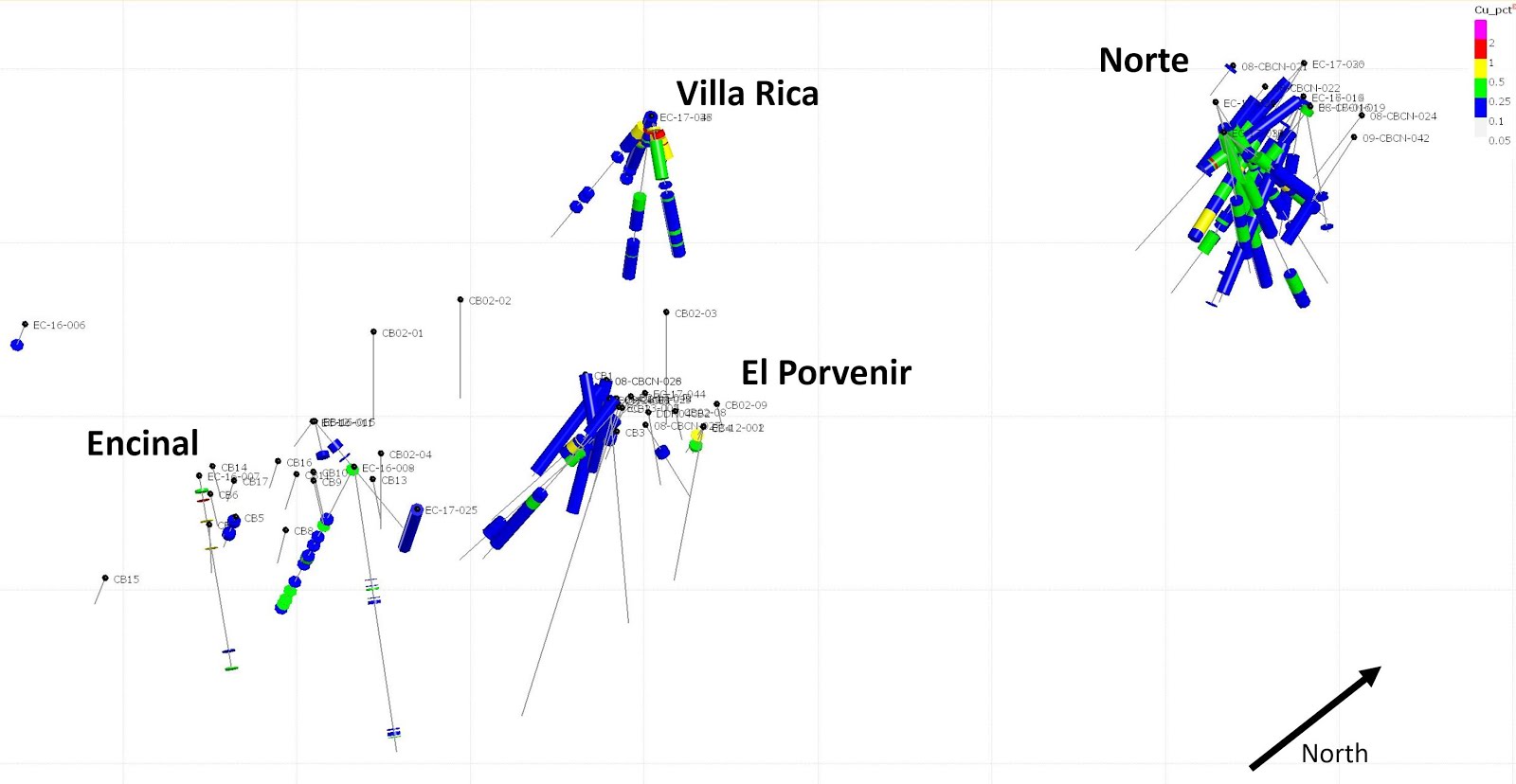
You can clearly see that the highest grade and thickest (i.e. the 'best') intercepts are from Norte, with a bit of copper at Villa Rica/Raya Tembrillo and some bits 'n' bobs in the other areas.

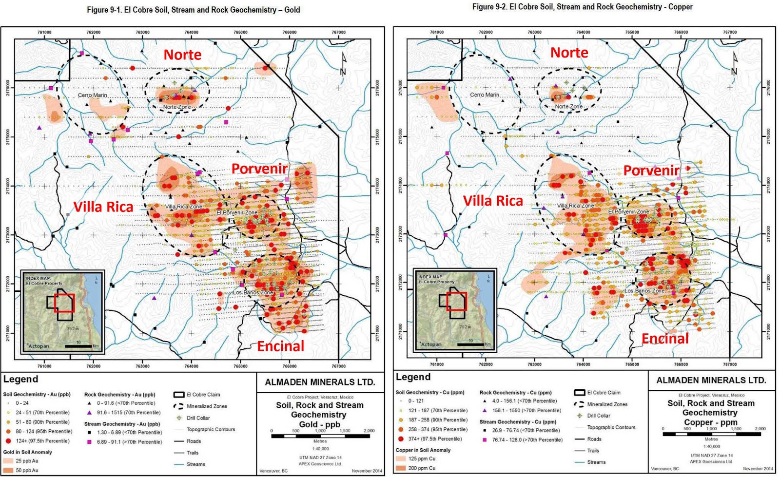
An interesting observation, when we compare the known targets against the soil geochemistry.

Au - left; Cu - right
We can see that the best area drilled at El Cobre, the Norte Zone has a minimal associated geochem anomalies, just a single line (Line 75800 - page 37 in the technical report), with some robust Au, Cu and Mo anomalies. I would love to see a regional map of soil Mo data as there could be a few other targets that could be interesting but where the Cu in the soils has been leached away.

Norte Zone

The Norte zone has received the bulk of the drilling and given the best results so far.

Au - far left = plan map with section lines, center = section A-A'; right = Section B-B'

Cu - far left = plan map with section lines, center = section A-A'; right = Section B-B'


We can see that Norte has been well drilled, the Au-Cu mineralization is well defined, with some >1 g/t Au zones in the core of the deposit and grading out into a lower grade (>0.25 g/t) halo. The mineralization is well drilled with most continuation to the mineralization closed off. However, the Au in hole EC-17-026 is still open to surface and to depth and would represent a good area to put a couple of holes as this could expand the 'resources' by up to 25%.


El Porvenir

Another regional target that has seen limited drilling. The standout hole has been DDH-04CB1 (drilled in 2004) that intersected 298m @ 0.38 g/t Au and 0.16% Cu.

Au - far left = plan map with section lines, Center = section A-A' - Au; right = Section A-A' - Cu
 The follow-up drilling isn't as special, intersecting several thick low-grade (<0.25% Cu) copper mineralization with a few narrow higher grade Cu-Au zones (dykes?). There may be some potential to the SW (left), but overall the grades are low and for gold discontinuous.

Villa Rica/Raya Tembrillo

We've only had a few holes drilled into Villa Rica, so it is hard to have a definitive opinion.

Au - far left = plan map with section lines, Center = section A-A' - Au; right = Section A-A' - Cu
Form the drilling so far, we can see that Villa Rica is more copper rich, with thick low grade intercepts (<0.25% Cu) with higher grade Cu and Au mineralization restricted to narrow zones - better mineralized dykes or breccias? It was also interesting to see high-grade copper at/close to surface - are we seeing some supergene enrichment?

I feel that the drilling to date shows that the potential at Villa Rica is limited. The geochem data shows a large target, but this may be an erosion anomaly (i.e. copper weathering down-slope towards the streams to the east and south).


Encinal

This is the area where Almadex hit a high-grade gold vein in hole EC-16-008.

Top left = plan map; top right - section A-A' - Au; bottom right = section A-A' - Cu

Again, we see generally thin, scattered intercepts, but hole EC-17-025 did intersect a thick zone of low grade (<0.25%) copper mineralization that could be peripheral to a larger system to the East (right).

Potential Problems

The most obvious problem could be the metallurgy. I haven't seen any mention in in the technical report about any basic met-work. It would be nice to know the distribution and style of mineralization (e.g. is the gold all in sulfides, or is there a thick oxide zone etc..) as this could have a big impact on the processing (dump leach vs milling) and recoveries. If you're interesting here is a link to a decent paper on the subject (link).


Summary

Overall, outside of the Norte zone, most of the economic Au-Cu mineralization appears to be restricted to narrow scattered intercepts. There may be potential to the east in Encinal, but nothing that is indicative of a large, well mineralized porphyry system.

For me, I can't see where the project could be expanded to >5Moz Au that could lead to development, and the regional targets don't appear to offer any upside.


Monday, March 26, 2018

Lupaka - a blast from the past

Lupaka Reports 9.86 g/t Au-Eq. over 130 m from Underground Sampling Program at the Invicta Gold Project

fuck me, that sounds great (link), but it is bullshit. 


They aren't lying directly to you, they've just resurrected one of those old favorite sleights of hand (ECU Silver were famous for doing this) by trying to impress you by misrepresenting the size of their penes mineralization by using the strike length rather than width.

I guess 12m @ 18.1 g/t AuEq wasn't good enough.

Here is an annotated doodle from the map accompanying the PR


I do like the fact that much more sampling has come from the Footwall vein, there is a sample every 5m (give or take), but only every 20m on the hanging-wall vein. I wonder which is better?

Even better is the way that they generously decided to include some of the HW assays (e.g. samples CH_16, 19 and 20) into the FW zone so that they could 'improve' its grade.

So now it is my turn to do some bad math:


I split out the assays by sample location (FW, HW and Combined)

  • FW vein
    • average width = 4.6m
    • average grade = 8.4 g/t AuEq
  • HW evein
    • average width = 5.8m
    • average grade = 6.7 g/t AuEq
  • 'Combined' veins
    • average width = 8.4m
    • average grade = 10.6 g/t AuEq
Not to shabby, but definitely not what was advertised on the tin. It also shows that the intersection zone between the FW and HW veins is an attractive exploration target to follow up and down dip as they could define a small, but high-grade ore-shoot. 


Wednesday, December 13, 2017

Timok - the Lower zone

Some updates to correct for some inaccuracies, and to update the resource table to include additional information.

And now for something completely different...

I wasn't expecting the Spanish Inquisition over Nickel Mountain.


Back to reality, Nevsun have been releasing some great results from the Lower Timok Zone (link), we can see on the accompanying plan maps and sections that this zone is large, but deep.

Figure 1 - The Plan Map

You can clearly see the footprint of the Lower Zone, with approximate dimensions of 1.5km wide by ~1km. To the south, we can see the smaller, but very high-grade Upper Zone.

Figure 2: The Section....
So we can see that the Lower zone extends from 800m to ~2000m below surface. I've added some annotations.

Figure 3: The horse chestnut---hurrah!

We can see that there is potential to extend the known mineralization to depth, and maybe to the West, where no deep drilling appear to have has occurred beneath the Upper Zone.

However, I commented in previous posts that one of the problems at Alpala was its depth. The initial drilling didn't appear to outline a resource that was sufficiently large or high grade to support the development of a stand alone, large-scale, underground operation. Do we have the same issues at Lower Timok?

I've compiled as much data that I can find for Lower Timok, and I've also included the recent (2016-17) drilling from the high-grade Upper Zone as well, just to allow you to compare their location, depths and relative sizes.

You can download the 3D viewer file from here (link).

The first step was to evaluate the size and grade for the Lower Zone. I created a series of grade shells for Au, Cu and CuEq (I used Nevsun's CuEq calculation 1g/t = 0.7% Cu). These are all included in the Leapfrog viewer file as well as all the sections from the December 4th PR.

Disclosure:

  • I haven't factored in any recoveries for Au and Cu when calculating the CuEq values
  • I have not been able to find any assays for holes TC150073 and TC160073B
    • These holes go through the center of the Lower Zone, and therefore my Bad Estimates (TM) are likely to be slightly low. I'll keep looking for this data,and when I find it, i'll update the model.

Here are the assumptions I used to create the grade shells in Leapfrog Geo:
  • Base range = 400m - the holes are widely spaced (they may even be too wide to determine an initial inferred resource)
  • Interpolant = Spheroidal
  • Drift = None
  • Specific Gravity = 2.7 (assuming the rocks are granitic in composition with minor sulfides)
  • I applied a filter so that the Upper Zone drill-holes would not be used to create the various grade shells.
Here is an updated "officially bad estimates" (TM) for the Lower Zone:


Just a couple of observations:
  • There appears to be a lot of contained metal at Lower Timok, 
    • the majority is too low grade for an underground operation and should be considered as 'mathematical' resources.
  • The overall gold content is low
    • Will the concentrates contain payable amounts of gold?
At the bottom of each table I've given a tonnage and grade at various cut-off limits. I'm going to use a 1% CuEq in the following section.

If we compare my 'resource' CuEq grades and plot them against the Macquarie Reseach report on large-scale underground porphyry projects.


Red dashed line = average grade for Lower Timok (using a 1% CuEq cut-off) = 1.28% CuEq
Blue star = cut-off value for a underground block cave operation for a brownfield operation
Green star = cut-off value for a greenfield block cave operation


Lower Timok grade vs other Block cave operations/development projects 
We can see that Lower Timok isn't quite good as a stand alone greenfield development project, but as it is adjacent to Upper Timok, with a quite robust PEA, we can considered Lower Timok to be a brownfield project, and now we see that it is high enough grade to pass the Brownfield hurdle grade.

However it isn't quite as simple as that. If we look at the recently released PEA from the Upper zone (link), and we are told:

  • Initial Capex ~$US615M
  • Mine Life ~15 yeears
  • Mining rate ~8,900 tonnes per day
  • NAV = $1.5B
If we compare this to Stage 1 for Wafi-Golpu project (link), which I think could be a good analogue to the hypothetical costs to develop Lower Timok.


You can see that I've highlighted some important values.

  • Initial Capex = US$2.6B
  • Ore mined and milled = 149Mt (approximately similar to Lower Timok)
  • Mine life = 28 years or approximately 15,000 tonnes per day
  • First ore milled = project development time line = 60 months or 5 years
  • Steady-state production = time taken to reach full capacity = 90 months or 7.5 years

So, if Nevsun were looking to develop the and mine the Lower Zone, it will require significant additional CAPEX, larger milling and surface facilities (tailings and waste dumps) than proposed for the Upper Zone mine. This means that Lower Zone is a half-greenfield half-brownfield project - I'll call it an Olive Project, and that Nevsun have a couple of options:

  1. Mine the Upper Zone, make lots of money and 'keep' the lower zone on their books as a large resource, but don't develop it.
  2. Mine the Upper Zone, and after 5 years start the permitting and development of the Lower Zone, and slowly increase the size of the surface facilities (Mill, tailings, waste dumps etc.), and bring the Lower Zone into production towards the end of mining the Upper Zone.

This is my hypothetical scenario for Lower Timok

  • Initial Capex = US$1.5B (the topography is significantly easier around Timok so less earth moving, and assuming that they will use and expand on the Upper Timok surface facilities)
  • Ore mined and milled = 200Mt
  • Mining rate = ~15,000 tonnes per day
    • Need to expand surface milling facilities by 5000-6000 tonnes per day
    • Expand the flotation circuits
      • I don't know how feasible this is, but it is something that Nevsun may need to consider to include as part of the development of the Upper Timok project, especially permits for expansion of tailings facilities as these may taken several years to obtain.
  • Development period = 3-5 years
  • Time taken to reach full capacity = 5-7 years (including development period).
    • The idea is that the project would need to be developed while the Upper Zone is being mined and then Nevsun can extend the infrastructure from the Upper Zone development into the Lower Zone.
At the moment, there aren't a huge number of drill-holes into Lower Timok, and the drill hole density is still quite low (approx. 300-400m between drill-holes), but the initial data shows a robust porphyry system, that is open in a number of directions.

The initial (i.e. very bad) review suggests that it could support a medium-sized underground operation, but its development is dependent on the economics of the Upper Zone and how Nevsun/Freeport decide to develop the Lower Zone.

Will Nevsun just focus on the Upper Zone or will they factor in the development of the Lower Zone into their future decisions for the project? 

For investors, the upside could be, that if the Lower zones becomes significantly larger (e.g.>500Mt at similar CuEq grades), would Freeport step in and take out Nevsun to consolidate their ownership of a large porphyry Cu-Au deposit not owned by a major mining company?


Saturday, December 9, 2017

Garibaldi - Mighty Massive Sulfides - The Return

We got the results from hole EL-17-14 today (link).

Summary:


  • Hole EL-17-14 assays are high-grade, but drilled down the guts of the Discovery Zone
  • Drilling still restricted to a 50m wide section, so 3D orientation of massive sulfide zones are hard to determine accurately.
  • However, the drilling to date indicates that the massive sulfide bodies are quite small, but most ore open in several directions suggesting potential to add, albeit limited, tonnages.

Pro-trick for Garibaldi - if you are going to put a table in your press release, don't include a sub-interval that is lower grade, it just shows that you are smearing a very high grade zone over the thickest interval possible.


It is also obvious that this intercept is not close to true widths as suggested below the table, but it shows that Garibaldi thought that the Discovery Zone was parallel to the upper sulfide zone intersected by holes EL-17-04 and 09 and dipping approximately to the NW.

this is their own interpretation from all of the data
This means that hole EL-17-14 was orientated to drill down the guts of the Discovery zone to try and get as long an intercept as possible, so here is my very simple interpretation, based on the intercepts in holes EL-17-14 and EL-17-09.

10.63m is almost 16.75 meters?
It looks like the Discovery zone is ~10-11m thick, based on the >2% Ni assays and reported massive sulfide mineralization.. This is significantly less than the 16.75m than Garibaldi are suggesting in the notes beneath the assay table.

I've brought the data from hole EL-17-14 into Leapfrog and created a new model (link), I've also done some officially bad mineralized material calculations (TM) to get an idea of the size and potential at Nickel Mountain, to see how GGI can justify a ~CND320m market cap.

Add caption
Here are my assumptions:

  • Search distance = 50 m, 
  • Specific Gravity - I've used an increasing value based on grade, using densities from Sudbury as a base (Note - SGs at the Eagle deposit average 4.44 t/m3)
    • >0.5% Ni = 3 t/m3
    • >1% Ni = 3.5 t/m3
    • >2% Ni = 4 t/m3
  • There is no specific orientation on mineralization - as all drilling to date is restricted to 50m wide plane.
If we compare Nickel Mountain, with the best-est-ist grades in the wurld, to the Eagle Deposit.
Eagle, Dec 2016 Reserves (Lundin Mining)
Eagle was acquired by Lundin Mining in 2013 for US$325M (link) or CND$416 (at current exchange rates), which is only CND$100m more than Garibaldi's current market cap.

Why? There are only 14 holes drilled at Nickel Mountain, no resources, and the massive sulfides appear to be narrow, and inconsistent. Before you hurl abuse at me, just take a step back and ask yourself - what does GGI have to warrant such a high valuation?

I also can't see the upside potential, and I don't like that GGI have been very poor at releasing quality data for the project (you could think there is a reason for this). We still have no plan maps, no geophysical sections, no presentations etc. This isn't something you would expect from professionals running a professional company.

Simply put - Nickel Mountain, Es Mundus Excrementi!

Boring Geology Bit


I've also included some scenes showing my interpretation of the various sulfide zones and their orientations that I can determine from the limited data available. I've split it into 4 separate zones, as I was intrigued by this statement.


Here are the various massive sulfide zones, I've decided to label them, as Garibaldi can't.


Using the data provided, I've created a series of estimated trends for each zone.


To create these trends I lined up the various massive sulfide/high-grade zones in 3D. It was fortunate that Garibaldi don't label these zones on their cross section or in the drill intercept tables.

I apologize to any non-technical readers, the following section is going to be full of geo-wank. I've included some features on the sections through each zone:
  1. Colors - the Zn grade shells on the section line
  2. Black line = 25m distance contour from each drill-hole
  3. Grey line = 50m distance contour
The distance contours show me where drilling has and hasn't occurred and is useful to identify areas that have and have not been drilled.

Discovery Zone

This is the zone that Garibaldi have been getting erections over, discovered by hole 09, but only recognized 5 holes later.

This zone appears to be almost horizontal, intersected by holes EL-17-02, 04, 09 and 14, but only holes 09 and 14 hit significant sulfides and mineralization.


We can see that hole 09 and 14 are just 20m apart, and the entire zone is only 60m wide, and closed off to the NW by hole EL-17-02 and to the SE by hole EL-17-04. However, it is undrilled to the NE and SW. For me it will be interesting to see if holes 10-13 explore this zone.

Upper Discovery Zone

This zone was defined by holes EL-17-04 and 09. It dips, relatively steeply to the west and is quite narrow (2-5m). 

biggus dickus
Drill-hole EL-17-02 has closed off this zone to the northwest. Hole EL-17-14, 100m to the east, and EL-17-01 ~50m to the west didn't hit anything, again suggesting this zone is quite small, but with expansion potential.

Northwest

This zone has been well drilled, it sits above the Historic Zone and appears to be steeply dipping to the SE.

Note: this section is orientated with north to the right.

So this zone is closed off to the south (left) with the drilling intercepting narrow >1% Ni zones. However, it is open to the North (right), with hole EL-17-08 intersecting ~6m of massive sulfide mineralization, so again, there is potential to expand this zone with additional drilling.

Historic

This is where exploration occurred in the 1960s. It has been well drilled by Garibaldi. To date 6 holes have drilled through this zone, but only 2, EL-17-03 and 07, have returned decent grades. It is closed off to the west by holes EL-17-05 and 06 that were unmineralized. To the north by hole EL-17-08 (unmineralized), and to the west by hole EL-17-01 that cut disseminated mineralization.

However, there is minor potential for this zone to continue to the NE, but the drilling by Garibaldi show that it is very small


So, all I can see is that the sulfides are small, have very variable thicknesses and grades over very short distances, but each zone is open in 1 or more directions. It will be interesting to see where holes 10-13 are located (I'm surprised that they were not able to release the assays from these holes as they were all drilled before hole 14 - could there be a reason - i.e. they are shite), if they are in the same Section, then, for me it just means that even Garibaldi knows that they are small and focusing on this small zone as it is the only area with evidence for massive sulfide mineralization. 

Tuesday, November 28, 2017

Garibaldi - mighty massive sulfide mineralization

I might as well jump onto the Garibaldi-bashing wagon. I had stood on the edge muttering to myself, how the feck are were they worth >$400M based on feck all?

Their website is shite, devoid of information and looks like it was created by a child, probably the same one who created the 'fact sheet', but at last we got a section through the Nickel Mountain, the first decent 'image' from the project....ever (link)

It is a shame that it wasn't accompanied by a plan map, which would be useful in showing the 14 Garibaldi holes and the location of the 1960s drilling?

When looking at a map/section - start with the basics
  1. Scale - look to see if there is a grid or scale bar.
    • Quickly see how far apart the holes are located (50-100m)
    • How 'big' the massive sulfides are 
  2. Legend - this tells you the colors used for grades and rock types
    • check out the dark grey = no assay = Nothing of interest (i.e. no sulfides) in the core
  3. How consistent is the mineralization - does it link up between adjacent holes?
    • No, we get a few scratchy hits, with a small disseminated halo.
You need to ask yourself, can I, armed with a mighty No. 2 pencil (HB in the normal parts of the world), join the zones together?

here is an easy one for Garibaldi to do
I'm not an expert on Nickel deposits, but I've decided to annotate it, to highlight some interesting features and I've made a few observations.


So, how big are our massive sulfides?

They are soooooooo massive, that each one has just been hit 1 hole. Approximate dimensions:

  1. Big Boi - reamed by hole EL17-14 = 29m x 12m
  2. Old MoFo - penetrated by hole EL-17-03 = 2m x 91m
  3. Skinny Man - pricked by hole EL17-04 = 5m x 50m

So we have 3 small, inconsistent massive sulfide bodies, with minor disseminated sulfide halos.

So, after a disappointing press release, how can you save face, well, we needs to ask the FAG.

Hello FAG* here, I was disappointed that Garibaldi were defeated by unseasonable Northern Canadian weather. Who would have thought that they would have had snow this time of year in the Polar Riviera.

(*Fraudulent Angry Geologist)

I was very disappointed with Garibaldi's program, a true professional would have moved holes EL17-01 approx. 20m to the left, that would have hit >100m of disseminated sulfides, but they redeemed themselves with Hole EL17-14. So, if you are a company like Garibaldi, dedicated to not releasing any useful information, my advice is, have some fun, and really do to town on the drilling. Here is my idea:

Proposed holes in GREEN
Those 4 holes are beauts, multiple sulfide hits and nice and easy. OK, you're drilling the same areas 2-3 times, but we are searching for 'geological continuity' not drilling for resources. Chuck in a few words like, structural complexity, offsets and everyone will be happy and you'll get some decent hits to keep the shareholders happy.

If those dipshit geologists keep bleating, remember that with all that cash you raised, you can keep giving yourself a huge salary for the next 3-4 years, which is a happy thought.

Just a note to Dorian Leslie - your maps are great.

Saturday, October 21, 2017

Tinka Update

I'm going to do a different spin on the post, initially focusing on the results and then look at some areas that have been under-drilled to see where Tinka can go to add some tonnes to and/or improve the quality (category) of their resources.

Summary

  • Some good infill holes (A17-085 and 096) in the core of the system
  • System is getting weaker to the east (A17-093) and to the SE (A17-094).
  • Narrow, albeit high-grade zones drilled to the east of the West Ayawilca resource (A17-083 and 085)
  • A few holes were drilled in the Chaucha, Zone 3 and Valley targets, but to date, no significant mineralization was discovered. However, early days.... 

Results

We are now looking at a mature exploration project. Tinka are now drilling the periphery of the South Ayawilca system, so the mineralization is now narrow and deep.

Blue = Sept PR; Red = Oct 2nd PR; yellow = result pending

Here are some sections

Hole A17-087 - SW end of the South Ayawilca Deposit
We can see that mineralization is dying out to the SW.


A17-071 (left) SE extent of mineralization


Mineralization dying out to the NE, but there are a few gaps. Hole A15-041 (to the right) hit multiple zones of moderate zinc mineralization.

The effect that this drilling has had on my officially bad resources is:

Full breakdown of ZnEq resources
We actually see just a slight increase in tonnes, but a decrease in grade. This is due to the slightly lower average grade due to all of the different cut-off limits.

This may sound negative, but essentially Tinka have been drilling at South Ayawilca all year, and have defined a new, deposit at Ayawilca. It will be interesting to see when a new technical report is released.

Opportunities

However, I have a question: Where are Tinka going to drill now? The drilling to date seems to have closed off the South Ayawilca deposit, where are they going to generate future intercepts and grow the resource.

There are 3 areas where they can focus:
  1. Infill drilling - designed to increase the confidence of the resource (increase the amount of M&I resources and reduce the amount of Inferred)
  2. Expansion - drill around the edges and between known mineralized zones.
  3. Green-fields - drilling of new targets
Each of these have a different risk vs reward levels, and I've spent a few days compiling as much of the drilling data as possible from technical reports and old press releases.

They have already started drilling some of the pother regional targets, but unfortunately, so far the results haven't been very positive, but we need to remember that they have only drilled 6-7 holes on them, so it is early days.

So, I will focus on the first two. Where are there: 
  • Under-drilled areas
  • Where some intercepts haven't been followed up on.
NOTE: there may be reasons certain areas haven't been explored (e.g. access issues, topography, hydrology etc.). I'm going to ignore these in this post as I'm not intimately familiar with the project.  

Unfortunately, I'm lazy. Fortunately, Leapfrog can all of the hard work for me. I drew a slice through the project, along the main zinc horizon.


I got leapfrog to create 50m and 100m (radii) buffers around each drill-hole.

Pink = under explored areas
I always do this as it shows me very quickly where there are un- and under-explored areas of a project, and as a simple geologist, I like to put holes in areas where they have a good change of getting high-grade zinc mineralization, like here:


Gaaaaaaapppp

That area is ripe for reaming. This is a perfect area for dumb exploration, simply whack a hole between 'em and you have an easy win! The area to the right of hole A12-008 could also do with a few holes as well, you'll get some decent grades for your PRs there.

However, this raises and interesting question for Tinka. Do they focus on drilling the known mineralization or start exploring the property for more deposits?

If they focus on drilling to improve the confidence in future resource calculations or keep looking for new deposits, and maybe even the BMF?