Showing posts with label Copper. Show all posts

Wednesday, December 13, 2017

Timok - the Lower zone

Some updates to correct for some inaccuracies, and to update the resource table to include additional information.

And now for something completely different...

I wasn't expecting the Spanish Inquisition over Nickel Mountain.


Back to reality, Nevsun have been releasing some great results from the Lower Timok Zone (link), we can see on the accompanying plan maps and sections that this zone is large, but deep.

Figure 1 - The Plan Map

You can clearly see the footprint of the Lower Zone, with approximate dimensions of 1.5km wide by ~1km. To the south, we can see the smaller, but very high-grade Upper Zone.

Figure 2: The Section....
So we can see that the Lower zone extends from 800m to ~2000m below surface. I've added some annotations.

Figure 3: The horse chestnut---hurrah!

We can see that there is potential to extend the known mineralization to depth, and maybe to the West, where no deep drilling appear to have has occurred beneath the Upper Zone.

However, I commented in previous posts that one of the problems at Alpala was its depth. The initial drilling didn't appear to outline a resource that was sufficiently large or high grade to support the development of a stand alone, large-scale, underground operation. Do we have the same issues at Lower Timok?

I've compiled as much data that I can find for Lower Timok, and I've also included the recent (2016-17) drilling from the high-grade Upper Zone as well, just to allow you to compare their location, depths and relative sizes.

You can download the 3D viewer file from here (link).

The first step was to evaluate the size and grade for the Lower Zone. I created a series of grade shells for Au, Cu and CuEq (I used Nevsun's CuEq calculation 1g/t = 0.7% Cu). These are all included in the Leapfrog viewer file as well as all the sections from the December 4th PR.

Disclosure:

  • I haven't factored in any recoveries for Au and Cu when calculating the CuEq values
  • I have not been able to find any assays for holes TC150073 and TC160073B
    • These holes go through the center of the Lower Zone, and therefore my Bad Estimates (TM) are likely to be slightly low. I'll keep looking for this data,and when I find it, i'll update the model.

Here are the assumptions I used to create the grade shells in Leapfrog Geo:
  • Base range = 400m - the holes are widely spaced (they may even be too wide to determine an initial inferred resource)
  • Interpolant = Spheroidal
  • Drift = None
  • Specific Gravity = 2.7 (assuming the rocks are granitic in composition with minor sulfides)
  • I applied a filter so that the Upper Zone drill-holes would not be used to create the various grade shells.
Here is an updated "officially bad estimates" (TM) for the Lower Zone:


Just a couple of observations:
  • There appears to be a lot of contained metal at Lower Timok, 
    • the majority is too low grade for an underground operation and should be considered as 'mathematical' resources.
  • The overall gold content is low
    • Will the concentrates contain payable amounts of gold?
At the bottom of each table I've given a tonnage and grade at various cut-off limits. I'm going to use a 1% CuEq in the following section.

If we compare my 'resource' CuEq grades and plot them against the Macquarie Reseach report on large-scale underground porphyry projects.


Red dashed line = average grade for Lower Timok (using a 1% CuEq cut-off) = 1.28% CuEq
Blue star = cut-off value for a underground block cave operation for a brownfield operation
Green star = cut-off value for a greenfield block cave operation


Lower Timok grade vs other Block cave operations/development projects 
We can see that Lower Timok isn't quite good as a stand alone greenfield development project, but as it is adjacent to Upper Timok, with a quite robust PEA, we can considered Lower Timok to be a brownfield project, and now we see that it is high enough grade to pass the Brownfield hurdle grade.

However it isn't quite as simple as that. If we look at the recently released PEA from the Upper zone (link), and we are told:

  • Initial Capex ~$US615M
  • Mine Life ~15 yeears
  • Mining rate ~8,900 tonnes per day
  • NAV = $1.5B
If we compare this to Stage 1 for Wafi-Golpu project (link), which I think could be a good analogue to the hypothetical costs to develop Lower Timok.


You can see that I've highlighted some important values.

  • Initial Capex = US$2.6B
  • Ore mined and milled = 149Mt (approximately similar to Lower Timok)
  • Mine life = 28 years or approximately 15,000 tonnes per day
  • First ore milled = project development time line = 60 months or 5 years
  • Steady-state production = time taken to reach full capacity = 90 months or 7.5 years

So, if Nevsun were looking to develop the and mine the Lower Zone, it will require significant additional CAPEX, larger milling and surface facilities (tailings and waste dumps) than proposed for the Upper Zone mine. This means that Lower Zone is a half-greenfield half-brownfield project - I'll call it an Olive Project, and that Nevsun have a couple of options:

  1. Mine the Upper Zone, make lots of money and 'keep' the lower zone on their books as a large resource, but don't develop it.
  2. Mine the Upper Zone, and after 5 years start the permitting and development of the Lower Zone, and slowly increase the size of the surface facilities (Mill, tailings, waste dumps etc.), and bring the Lower Zone into production towards the end of mining the Upper Zone.

This is my hypothetical scenario for Lower Timok

  • Initial Capex = US$1.5B (the topography is significantly easier around Timok so less earth moving, and assuming that they will use and expand on the Upper Timok surface facilities)
  • Ore mined and milled = 200Mt
  • Mining rate = ~15,000 tonnes per day
    • Need to expand surface milling facilities by 5000-6000 tonnes per day
    • Expand the flotation circuits
      • I don't know how feasible this is, but it is something that Nevsun may need to consider to include as part of the development of the Upper Timok project, especially permits for expansion of tailings facilities as these may taken several years to obtain.
  • Development period = 3-5 years
  • Time taken to reach full capacity = 5-7 years (including development period).
    • The idea is that the project would need to be developed while the Upper Zone is being mined and then Nevsun can extend the infrastructure from the Upper Zone development into the Lower Zone.
At the moment, there aren't a huge number of drill-holes into Lower Timok, and the drill hole density is still quite low (approx. 300-400m between drill-holes), but the initial data shows a robust porphyry system, that is open in a number of directions.

The initial (i.e. very bad) review suggests that it could support a medium-sized underground operation, but its development is dependent on the economics of the Upper Zone and how Nevsun/Freeport decide to develop the Lower Zone.

Will Nevsun just focus on the Upper Zone or will they factor in the development of the Lower Zone into their future decisions for the project? 

For investors, the upside could be, that if the Lower zones becomes significantly larger (e.g.>500Mt at similar CuEq grades), would Freeport step in and take out Nevsun to consolidate their ownership of a large porphyry Cu-Au deposit not owned by a major mining company?


Wednesday, November 8, 2017

The Valleys are full of crappy copper deposits......

Vizcachitas, the "Largest Independent Copper Project in the Americas" we are told by Los Andes. All that is missing is "undeveloped", to really tell us how great the project is!


All projects are great from afar.....

Summary

  • A large, but low grade resource and with a very small 'high-grade' zone. 
  • Good recoveries, but minimal by-product contribution
    • >95% for Copper
    • 55-70% for Mo
  • Expansion of near surface resources looks limited, but hole V2017-10 did intersect some interesting grades at depth.
  • Bad geography, located in the bottom of a relatively steep valley, this could have big implications on strip ratios as minor changes in pit slope angle may mean moving very large amounts of waste rock.
  • 2014 PEA show that a small (40 ktpd) operation is very marginal and that very minor (5%) increases in CAPEX or OPEX will have a major impact on the project economics.
  • So, Vizcachitas is too small, too low grade with marginal economics. As they say, can't make a silk purse out of a sow's ear.
*resources haven't been updated to include the 2015-17 drilling.

Geo-babble


DISCLOSURE: I've compiled as much of the information as possible that is in the public domain. However, I've had to estimate the angle of dip, and I'm sure that I've only been able to find summarized assay data for ~65% of the 'deposit'.

You can download the Leapfrog project from here (link)

Resources


The first area I wanted to look at is the quality of the resources, especially the tonnage at high, medium and low cut-off grades.

lots of high-grade, just not in the resources....
So we can see that the majority of the deposit is very low grade, and a small part (only 19%) of the indicated resources scraping over 0.5% Cu.

However, the recent drill results have been interesting (link) with some (reported) thick, reasonable grade intercepts, but we need to check where these holes have been drilled (link).


You can quickly see that the majority of the new holes are clustered in areas of known mineralization, with a couple, including hole V2017-10 drilled to the north.

In the image below I have created a >0.4% Cu grade shell for the project using (left) pre-2015 drilling and (right) all drilling. To see how the resource has changed.

changes circled in red
There is a new area to the north, centered on hole V2017-10 and some minor expansion around the edges of the known mineralization. There are no new high -grade zones, and when you look at it, the >0.4% Cu grade shell is quite poddy and doesn't form a nice solid consistent zone with a high-grade core.

Here are some sections, you'll notice that the >0.4% Cu zone doesn't extend to great depths.

Section 2800N

Section 3400N

Section 3900N

These zones aren't very thick, but we can see that the mineralization in Hole V2017-10 is open in several directions, but is deep, all other mineralized zones appear to have been close off or are very narrow, so unfortunately, I can't see much exploration upside.

Development


There are rumors that Los Andes want to re-market Vizcachitas as a small (40,000 tonnes per day), high grade deposit, and we are fortunate that a financial analysis of a 44,000 tpd operation was include in the 2014 PEA.

I mean, I like the fact that they are so modest, a discounted NPV of just US$3 million is quite cute when compared to other large copper projects, and a leisurely payback period of a decade, I mean why make money quickly, when you can make it slowly and savor it.


I mean look at the numbers, all the best projects, like Livengood's epic 2013 PEA, you have a positive IRR and a negative (discounted) NPV.

It is going to be a lot of fun developing such a marginal project, where any minor increase in CAPEX or OPEX with rape you up the ass. Personally, I can't think of any mining project that has every gone over budget or not completed on time.

One the cross sections above I put on the surface trace. It shows that the mineralization is found at the bottom of a steep valley, that Los Andes loves to take photos of:

a river runs through it..


So, it is a bit hilly, has a river than runs through the project (that hopefully isn't a water source for any urban centers), so another factor that will impact the economics of the project is the pit slope angle. Back in 1999, Golder estimated a 42-47 degree angle, and I've doodled it on the best section, along with steeper and gentler angles


You can see how much additional rock (grading less than 0.4% Cu) needs to be moved.
The same will happen if you decide to mine the deeper resources, as you go deeper you needs to move more and more low-grade waste rock on either side of the deposit.


So, after all of this blathering, you can see that the project simply isn't good enough, the economics are crap, and just a minor change in CAPEX, OPEX, metal prices, rock quality and stability can conspire to wreck it. The recent exploration data hasn't shown any upside, just a single hole that hit some medium grade mineralization at depth.

Monday, July 3, 2017

Hole 23

DISCLOSURE: I own shares in Sol Gold.


Question: What is the easiest way to find a million ounces of gold!

Answer: Drill a hole through the guts of a high-grade copper-gold porphyry

Each of those squares measures 300m
Here is hole 23R from Alpala (link). It went straight through the core of the Alpala deposit. There is a lot of grade smearing going on. In reality they only drilled 474m of economic mineralization (>0.5% Cu and 0.5 g/t Au), with a spectacular high-grade heart grading >1% Cu and ~3 g/t Au.

Here are the updated official bad resources:

A nice jump-up in contained metal!
Alpala will be an underground operation, and here is an excellent summary on costs involved for block cave operations - link. Here are some comparative sizes of some of these projects:
  • Cadia: 1.5BT @ 0.47 g/t Au, 0.27% Cu
  • Hudo Dummit: 500Mt @ 1.66% Cu, 0.35 g/t Au
  • Resolution: 1.8Bt @ 1.54% Cu
Brown = brownfield projects; green = greenfield projects
When we look at the project listed in the figure above we can see that there are 2 types of projects:

Brownfield

  • Satellite, high grade deposits next to an active open-pit mine
  • Depth extension of ore-bodies that were mined by an open-pit but now is too deep to be mined from an open-pit

Greenfield

  • standalone development projects
The reason I highlight this is that the cost to developing a brownfield deposit next to an active open pit mine or going underground to mine the deeper part of the same deposit a lot cheaper than building a new mine one from scratch. This also means that brownfield projects don't need to be as large or as high-grade to be developed.

At the moment, Alpala isn't quite big enough or high-grade to be a stand-alone operation, a few more holes like 23R will help! However, this is where the other exploration targets come in.

From Sol Gold June presentation
At the moment, all drilling has focused on Alpala, let us have a look at Aguinaga.

the hair nicely outlines the Cu mineralization found in a porphyry
We are told that they plan to start drilling there later this year. From Surface mapping and sampling they found some nice juicy rocks at surface, that look very similar to what they have been drilling at depth at Alpala.


Here is Aguinaga and Alpala. What Sol Gold are drilling at depth appears to exist at surface at Aguinaga.


Imagine what would happen if they found another Alpala at Aguinaga?


Thursday, April 27, 2017

Camino Minerals - initial review

Camino have released some interesting results from the Los Chapitos project in southern Peru (link and link)

Summary

  • Good
    • Great result from hole CHR-002
      • but, we have grade smearing, outside the >2% zone, it drops off to 0.84% Cu, still good, but could be marginal for an open pit operation
    • Small, near surface oxide zone
    • Some other interesting targets to be tested around the property
  • Bad
    • It was a shame that they went with cheapo RC drilling option as it meant:
      • Hole 002 terminated in good copper mineralization
      • Holes 004 and 005 couldn't reach the extension of this zone.
    • Typical grade 'expansion' - the high grade (>1% Cu) is found in narrow zones surrounded by low grade (0.2-0.3% Cu).
  • Trench samples look good, but I'm skeptical of trench sampling as:
    • remember - you can bias them by sampling along a mineralized structure rather than sampling across it - the FAG will explain how you can 'improve' your trench results
Is water, or the lack of, going to be an issue?

They are drilling using an reverse circulation rig, so as they mention in the March 29th PR (link), so they will be drilling 200-300m/day and they will finish the program about now....

There are advantages and disadvantages with using an RC rig:
  • Advantages
    • Quicker - drill 200-300m per day compared to 50-100m for a diamond drill
    • A lot cheaper - ~50% of the cost (or even cheaper) of a diamond rig.
    • Doesn't need water - very useful in the Atacama desert
  • Disadvantages
    • Lower quality geological information
    • greater deviation - the holes drilled by Camino started at 45 or 50 degress, but steepened to almost 80 degrees at the end of the hole.
      • if you see any company not-surveying RC holes, that is a good sign that they don't know what they are doing and that the data from these holes are suspect as they can't accurately tell you where the mineralization is located.
    • bigger visual impact
    • require more site preparation - wider roads, larger pads
    • generally limited depth - ~300m depth is generally the deepest you can drill with RC
    • can have grade issues - smearing of grade, especially at the water table
However, for exploration, you have to balance cost, speed against geological information. We can see its limitations, CHR-002 stopped in >1% Cu mineralization, and with a diamond rig you could push the hole on (if you have enough rods) and see exactly how wide that zone is.

TL:DR: They started off good, but by using the wrong equipment, they have are not maximising the value they are getting from teh drilling (unless drilling magnetite-rich zones is the objective).

Geology Wank

Hole CHR-002, very good zone, but as the hole stoped in mineralization we don't know how wide it will be.

Follow-up holes 003, 004 and 005 intersected the upper copper oxide zone, but due to hole deviation, which is common in RC drilling, they all steepened and didn't reach the target. The irony is, this deviation was seen in holes 001 and 002 and I would have expected Camino to have modified the program accordingly, as they showed us that there was a very high probability that holes 004 and 005 would have steepened (go more vertical) and not hit the copper zone.

I'll explain it visually, I prepared this image form the original press release


  • Red line = planned hole trace (i.e. where they wanted the hole to go)
  • Colored line = actual trace of the drill-holes
  • Difference between these lines = the deviation
    • we can see that as the hole gets deeper, the hole steepens (becomes more vertical)
    • We can also see that the holes can only be drilled to around 300m - this is as far as this RC rig is able to drill at this project.
  • Magenta line = what I think hole CMR-005 will do - it will hit the upper zone (my guess ~20m @ 0.6% Cu) and not reach the copper zone.
This is from the latest presentation

bendy drillholes
Look how much blue (0.1-0.3% Cu) is included in that 44m zone grading 0.86% Cu!

so that makes them 0 from 3

So you can see how much the holes are bending by (up to 20 degrees), and that makes it hard for the company to hit the planned targets, which is the reason why holes 004 and 005 missed.

You also need to think about the how the mineralization occurs, is it:

  • flat lying bodies
  • Steeply dipping narrow zones
  • large stocks
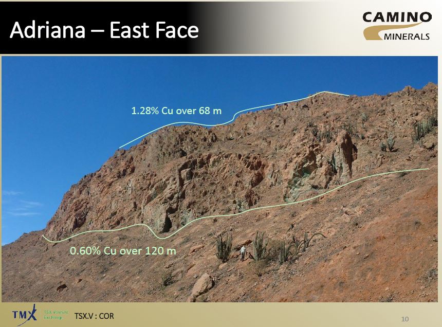
When we look at the presentation they show us some photos of some old workings.


They look to be nearly vertical, indicating that this how the mineralization occurs at Adriana.If the deep mineralization hit in hole 002 is vertical, then that zone may only by ~ 40m thick.


I think That Camino need to rethink their drilling strategy! They need to get some diamond rigs up there to answer questions on controls and size of mineralization. Continuing to drill RC-holes will start to reduce the value the company obtained from hole 002.

I've created a quick model of the drill-holes with their sections, so you can see how all the holes relate (link).

Look at how the Magnetite rich zone changes between sections...

Trenching results

Hello, FAG here.  Camino have given us some nice photos of some green-stained rocks in the Atacama.

Clouds!!!
Azurite skies...
and some photos of some old workings

Mein Mine

I've annotated the mine photo to show how you can get Maximum Impact (tm) results from trenches.


We have 2 trenches

  • Trench 1 - running parallel/along with the copper zone
  • Trench 2 - running perpendicular to the copper zone
Which will give the 'best result' for your press release?
  • Trench 1 = 30m @ ~1% Cu
  • Trench 2 = 3-5m @ 0.6-1% Cu
The question you need to ask is:


Mineralization

This was covered in the IKN post, so I've just included a image of a simplified mineralization zoning in a copper deposit


So, the upper zone is primarily oxide material, it may have some native copper and copper wad that is insoluble accounting for the 25% of the material that isn't acid soluble.

However, the lower zone is high-grade, contains only 25% soluble material, I wonder if this hole hit the enriched zone and we have a lot of Chalcocite.

Thursday, April 13, 2017

SolGold Update

DISCLOSURE - I own shares in Sol Gold. I'll try to make this post unbiased, but I want everyone to buy lots of shares so that I can make some money!

Over the last couple of weeks we've received the results from holes 19, 20R and 22 (link and link).

Summary

TL:DR version: Inline with expectations
  • Economic (>1% CuEq) mineralization is deep (~600m depth)
  • Hole 19 - drop-off in grade, as you move away from the core of the deposit (hole 16)
  • Hole 20 - clipped the edge of the deposit, didn't get much.
  • Hole 22 - Inline with expectations - >1% zone is quite narrow (100m core length)
They are having drilling issues - several holes lost before reaching target depth, and have changed contractor to resolve them.

I'm concerned about grade-smearing. When you separate out the high-grade zones, you are often left with wide-zones of much lower grade (sub-economic?) mineralization.
e.g.
  • Hole 22 - 730m @ 0.52% Cu and 0.23 g/t Au becomes
    • 100m @ 1.1% Cu and 0.57 g/t Au
    • 630m @ 0.43% Cu and 0.176 g/t Au
  • Hole 19 - 1344m @ 0.44% Cu and 0.28 g/t Au becomes
    • 552m @ 0.68% Cu and 0.45 g/t Au
    • 792m @ 0.27% Cu and 0.16 g/t Au
This shows we have a high-grade (>1% CuEq) core surrounded by lower grade mineralization, which is normal for porphyry systems.

TAG Officially Bad (tm) resources

  • Au - increased to 4.74Moz (542Koz or 13% increase)
  • Cu - increased to 1.7Mt (198Kt or 28% increase)
looking good...
The key is going to be the cut-off grades that are used to calculate the resources.

Predictions

  • Hole 21 - 925m @ 0.5% Cu, including a 400m >0.6% Cu - hole only 100m from hole 16, whihc hit a lot of good stuff
  • Hole 23 - being drilled, target between holes 16 and 19, so I'll expect
    • 200m >1% Cu and 1 g/t Au (@ 1,000m depth), within a 1000m zone of 0.3-4% Cu and 0.2-0.4 g/t Au
  • Hole 24 - keep an eye on this one, 3 scenarios (2 good and 1 bad)
    • Gets not much as it is drilling the peripheral part of the Alpala porphyry (i.e. lots of pyrite and not much else)
    • Drills deeper and hits the continuation of the Alpala porphyry
    • Drilling the peripheral part of the mineralization mapped at Malte Creek
  • Hole 25 - being drilled ~100m south of hole 19, so I'm estimating
    • 600m @ 0.3% Cu and 0.2% Au
    • drilling below hole 003 that hit a couple of narrow zones @ ~0.3% Cu and 0.1 g/t Au

The Good

Hole 19 hit reasonable mineralization, inline with what you would expect when you are drilling away from the high-grade core in holes 12 and 16. 

left = split assay results; right = super duper PR assay results
Hole 24 is going to be key, from the description (lots of pyrite and trace chalcopyrite and bornite), it suggests that it has intersected edge of a porphyry, but is it:
  • Part of Alpala system - they've extended it by >1km, which is huge, this could move Alpala into a >10Moz Au deposit
  • If it is associated with Malte Creek target - a separate, smaller Cu-Au system. Good.
  • If it is the distal part of the Alpala system - nothing changes
Gut feel - the middle one, we'll have to wait for the results to see what grades they get.

The Bad

Hole 20 appears to have clipped the edge of the Alpala system. Even though the hole was lost, I doubt that it would have got much more, so it basically tells us that the exploration potential to the east is less than thought.

left = split assay results; right = super duper PR assay results

I did enjoy the lip-sticking (applying lipstick to tart up some average results), done by the IR department, but Hole 22 (designed to see if the Cu-Au zones goes to surface) was a classic Playtex (tm) hole - looks great from afar, but once you get it open, everything disappears.

geoporn is always crap
However, the results from both  are what I would expect from holes that are drilling the edge of the system. We are seeing a gradual decrease in Cu and Au grades away from the center of the system (around hole 16).

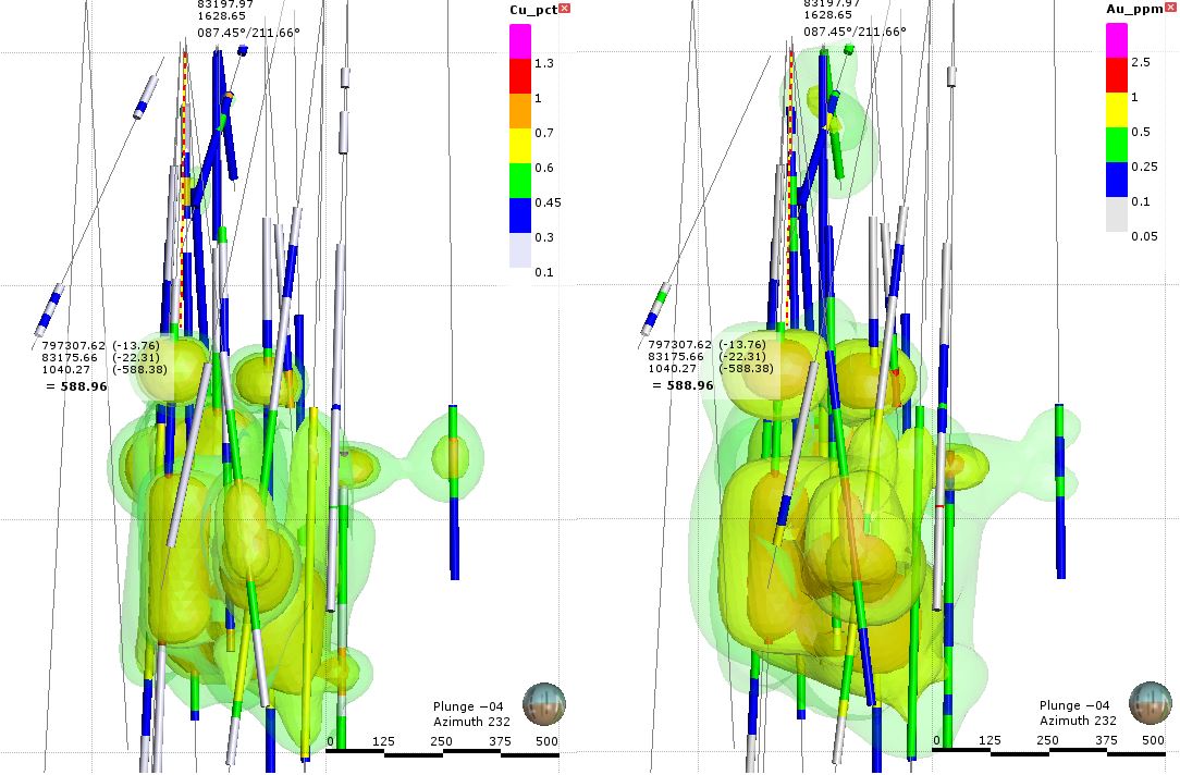
left = Copper; right = gold
you can download the 3D view from here (link)

The Ugly

Sol Gold are drilling 1500-2000m drill-holes. So each hole will take 2-3 months to be drilled (I'm assuming 800-1000m per rig each month). You can now see how important it is to use decent drilling contractors, as you don;t want to have invested >$100K and more importantly time into a hole that is lost before it hits the target!

Losing a couple due to poor ground conditions is expected, but the fact that Sol Gold tell us that they have changed contractors suggests something more - maybe they were using old equipment and inexperienced drillers?  

Conclusion

When you split out the high-grade intervals you see that the best mineralization is deep (starting at around 600m) with a high-grade core that grades outwards into lower grade mineralization. For me, the key is to keep your eye on the 0.7% CuEq contours that SolGold put on their various sections. Fe me, this is a reasonable proxy for the economic limits of mineralization. If you carefully check Figure 6, you can quickly see the disconnect between the long mineralized intercept reported in hole 22


So essentially SolGold have given you a quick way to check their results and ignore the PR headlines and look at what the data is telling you.

What I would like to see

Some work on the other targets, it would be nice to know when they will be thinking about drilling the other targets. Alpala is now a mature exploration project and the new results aren't as flashy as earlier ones and people will start to get Alpala fatigue. It will be nice to have a rig exploring adjacent targets, as Sol Gold could find higher grade zones at surface where there will be amenable to open-pit mining.


Tuesday, March 14, 2017

Tethyan Resources

Serbia hasn't been this popular since 1999. We've lusted over the intercepts that Reservoir had been reported prior to their takeover by Nevsun, and so many junior companies are heading there to hope that there are other world-class deposits to be found while enjoying a glass of Italian Riesling.

you want to be in the turquoise and moldy lemon colored areas.
We can see that there are a lot of deposits, and mineralization types, but only a few would you class as being any good.
  • Bor - 2.1Gt @ 0.64% Cu and 0.24 g/t Au
  • Majdanpek - 1Gt @ 0.6% Cu and 0.35 g/t Au
  • Chelopech - 60mt @ 1.2% Cu and 2.4 g/t Au
  • Timok - 1.7Mt @ 13.5 % Cu, 10.4 g/t Au and 35Mt @ 2.9% Cu, 1.7 g/t Au
The rest are decidedly average, but it is important to note that ALL the best deposits are found in the early morning-urine colored belt in the NE of the map (where the world Bulgaria is located)

This isn't where Tethyan have their projects. Gkcanica and Suva Ruda are found in the orange Vardar Zone that hosts some medium-sized low grade Cu-Au deposits, like:
  • Tulare - 523Mt @ 0.24% Cu and 0.23 g/t Au
  • Lece - 3.3Mt @ 3.7 g/t Au, 3.3% Zn, 1.5% Pb and 20 g/t Au.
This doesn't mean that there isn't a large deposit lurking somewhere in this belt, but does indicate that:

It ain't elephant country, mate

Summary

  • Small low grade porphyry Cu-Au deposit drilled at Rudnitza with 
  • Narrow zone of supergene enrichment
  • Mineral belt isn't well-endowed
Nothing here screams "major discovery", some average exploration holes, and it will be interesting to see what Tethyan do next. Will they stay-married to the project - keep spending more and more money on it as they have nowhere else to go, or start to do some regional exploration to see if they can find something better?

Geology

I am interested to see the relationship between the recent drilling and the drilling conducted by Phelps Dodge in 2004, especially holes PDRC-04-03 and 04. I'm going to guess that this drilling was designed to confirm the grades seen in those holes (does this old data exist?) and to see if mineralization continues to depth. Here are the new results:

Reasonable for initial drilling
A cursory glance at the data shows that for an early stage project, this is the first drilling, they hit some interesting grades, particularly gold (some consistent, sub-economic grades on its own) with a narrow zone of high-grade copper zone relatively close to surface.

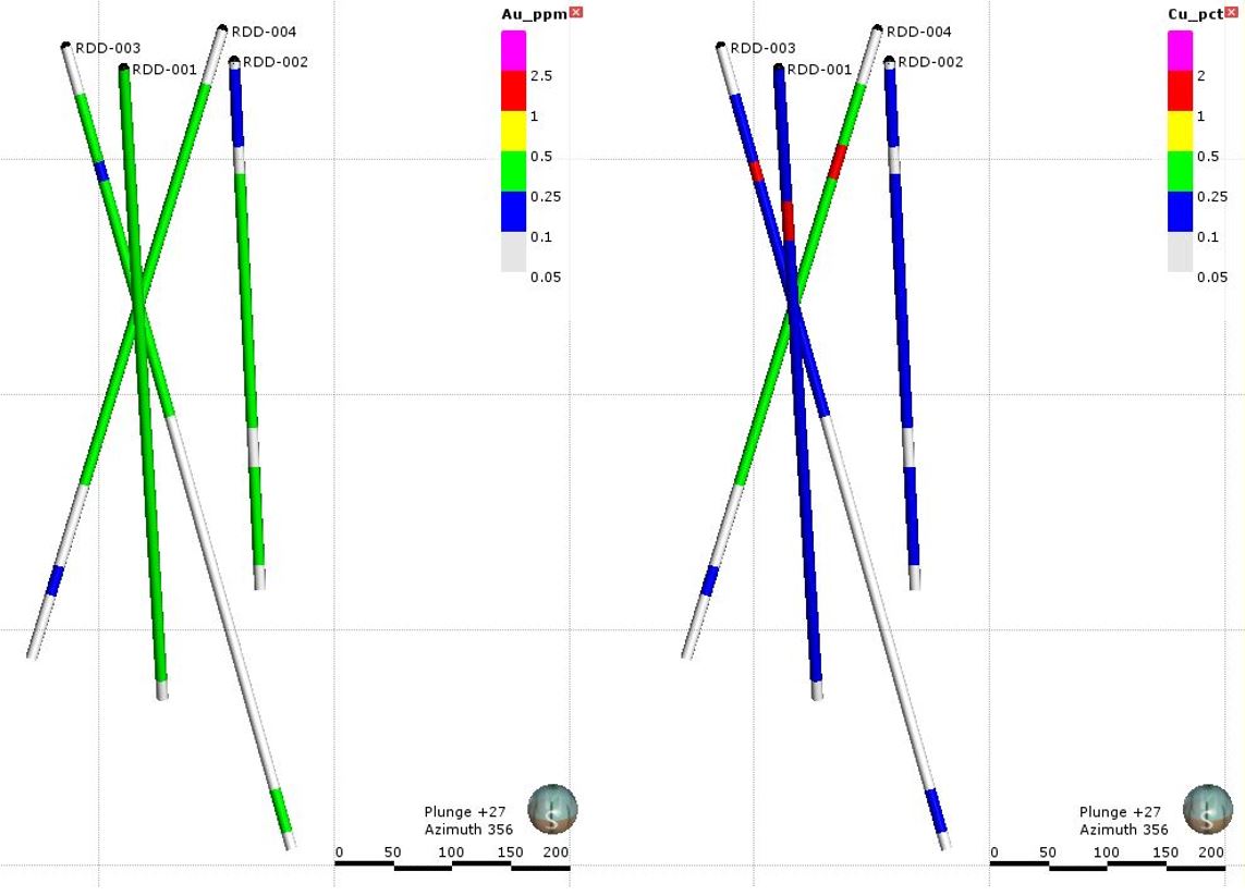
However, if you take a bit of time and look at the maps and sections on the webpage (link), you can quickly see that 3 of the 4 holes have drilled the same rock from 3 different directions, and a single hole (002) has explored for the continuation of mineralization 100m along strike, where we can see the grades drop-off considerably (3D model here - link)

Left = gold, right = copper

Here is an annotated section, and you can see that all Tethyan have is a small, poorly mineralized porphyry deposit.The small high-grade supergene zone looks interesting, but is small and restricted to the porphyry. The main body is too low grade to really warrant further work, and the 'deeper' zone, is too deep and low grade to really be of interest.


I guess they were trying to 'better understand' the mineralization, but it is frustrating that a company that has spent all that time and money on permits, building  access roads and drill-pads that they didn't do something a bit more dynamic. Why drill the same rocks from three different directions?

Let's be reasonable, we are talking about a junior exploration company, funds are tight, they had a well mineralized hole (visually) in hole 001. They did a step out (hole 002) 100m away, and it didn;t get much. So, I assume they panicked, played it safe, and went back to poking around hole 001 to make that they hit something. It keeps the risk low, but also minimizes upside.

Without having some regional geophysics maps or regional geochem it is hard to gauge the potential outside the Rudnitza porphyry. Normally companies drill the best target first. so if that is the case, they may want to spread their wings and see if they can find something better elsewhere.

So, imagine that you have just finished hole 002, it was bad, and you are thinking "what the feck do I do now"? 

What would a weaselly geologist do?

Here is my alter-ego, FAG (the Fraudulent Angry Geologist), and ask him - what BS can be spun from this project?

We have to assume that the FAG has 1/4 a brain-cell and is evolved from stoats


Remember - if you are investing in Junior Mining stocks, you are the Rabbit!

You saw that there was some good stuff in hole 001, not much in 002, so let us re-imagine the drilling, taking the ~1200m that was drilled in holes 003 and 004 and see what we can do!

We know that the deeper mineralization is low grade, so why not focus on the near surface supergene zone, this can be drilled with a few 150-200m long drill-holes.
proposed holes in red - >0.5% grade shell in yellow
Plan view
That would have allowed you to release lots of press releases with 30-40m @ >1% Cu and >0.3 g/t Au. Imagine those CuEq and AuEq PR headlines, that would suck investors in.

Even better, if all 6 proposed holes hit the high-grade supergene zone you could do a nice BS resource report to define a small (200m x 200m x 30m) resource (3.25Mt @ 1% Cu or 70 million lbs of copper), and start promoting the heap leach potential. the opportunities are endless!

Tethyan, you missed a trick there!


Tuesday, February 14, 2017

Cordoba - San Matias

Disclosure: I also hold shares in Cordoba, I feel that Alacran is a good exploration stage project. Cordoba have found a decent, at the moment small (~50Mt), well mineralized deposit. I am hoping that this will be the first of many similar deposits found around their property.

We see the share price surge after Cordoba released assay data from a spectacular drill-hole at San Matias (link).

I've annotated so it is simpler to understand
I was a bit disappointed they didn't include a map showing where the hole was located, so that we could relate it to earlier drilling.

The initial resource was a good start (link), I was surprised that they didn't wait until they had a larger resources (say >100Mt), but I assume that they felt it was important to release an initial resource and build on that.

What I have done is take the data from the recently released DH data to see how much more mineralization they have potentially drilled at Alacran. Here is the official resource:


Since the initial resource calculation, Cordoba have released the data from an additional 14 holes (link). Unfortunately, Cordoba don't give any decent plan maps to accompany the press releases, the ones they do release as missing grid coordinates and they don't label all of the holes which means I have to guess which hole is which (I'll let you make various innuendos).

UPDATE: I've had some feedback, and the reason that Cordoba don't release the drill-hole coordinates isn't just to piss me off, it is to prevent the informal/artisanal/illegal (select as appropriate) miners from knowing exactly where Cordoba have been drilling and going to those places and start to mine. In many countries in S. America dealing with informal miners can be very difficult and I can understand CDB taking measures to prevent this.

Some holes are labelled, but the other holes listed in the PR are the black colored ones. Nice and easy!!
Here is my 3D model (link), and you can see like the cross sections that Cordoba show on their website, you can see that the mineralization is restricted to specific rock units.


You can see that we have gaps in mineralization, these are unmineralized areas and are fairly common in porphyry systems. Typically they are caused by later, unmineralized intrusives (dykes - Panoro's Cotabambas project is a good example of this) cutting through the mineralization. Here they appear be caused by maybe less reactive or more competent units within the siltstones. It isn't clear.

Here are my officially bad (tm) resource calculations. For this I've used the following parameters:

  • Specific Gravity = 2.8
  • A trend on mineralization that follows the sediments
  • 200m search (i.e. Leapfrog connects intervals that are within 200m from one another)
red line = trend for grade shells

Here are my estimations with all the recent drilling:


So we see he have had a nearly 20Mt increase in resources and we haven't seen a drop off in grade, which is nice.

In the leapfrog model I've also included a few historic holes drilled at Montiel East.

Nice thick copper zones, starting at surface!
They got some very good intercepts including ~100m (from surface) @ 1% Cu and 0.65 g/t Au which is very nice! Some impressive grades, and I would be interested to see some more holes drilled in this area sometime in the future.