Thursday, February 9, 2017

SolGold - Hole 18

Damn, damn, damn, damn, damn why didn't I buy more shares. Cock!

Ok, SolGold have released the best of hole 18 last week, I was playing doing fieldwork and missed it, and the share price went up a little bit today.

This is what the hole 18 looks like.

I've doodled on what I think the mineralization looks like at Alpala
It was drilled approx. 90m away from hole CSD-14-008, and we can see its impact on my official bad (tm) resource calculations:

Copper

A nice 14% or 8% bump depending on the cut-off

Gold

A sweet 15% bump
This is what I think the outline of mineralization looks like at Alpala


If drill-holes 21 and 22 get some decent hits, we could see a nice bump up in resources, and I would like to see some drilling from the rig 4 site (to the west of hole 2), to see if the high grade zone continues to the SW?

Again, you can download the model and updated spreadsheet from here (link)


Tuesday, February 7, 2017

Hermosa - drilling update and geology review

We've got another batch of drill results from Hermosa (link and link).

Summary

  • Majority of the new assay data is from infill holes (7 of 10 holes) that intersected similar grades to surrounding holes
    • We see a lot of grade inflation - thick zones are in reality a much narrower high-grade zone, surrounded by low grade rocks (e.g. hole 403)
  • NW DH looking for the continuation of Taylor weren't anything special:
    • Deep, narrow, low grade CRD mineralization - it looks like the system is dying out in this direction
    • Shallow, high-grade vein mineralization - maybe this should be their focus for future drilling in this area?
  • Permitting - Arizona Mining are pushing shit uphill with this project, mate.


Technical junk

Here is the accompanying map for the first release, with my annotations to help you understand the maps a bit better.

Taylor deposit drilling - Jan 17th PR (Source: Arizona Mining website)
Here is a another version showing the location of the private (patented) mineral concessions and public (unpatented - i.e. where AZ can't drill) land.
Red hatched areas = can't drill here
and looking regionally
Green shaded areas = public land, unshaded areas are private land. Taylor deposit is at the bottom of the image.
Not many places for picking and poking with drilling

Arizona mining did want to drill in the public land, but unfortunately their recent application for 8 holes was cancelled (link), and they have another permit for 5-6 exploration holes that are on-hold.


You can download the enture permit application and maps from here (link).

A big thanks to LM for that info.

The Question is this:
Do Arizona management need to inform their shareholders and the market that their permits to explore on public land have been cancelled? Is this of material importance to the project?

I feel it is, but then again, I'm a geologist and know nothing


As I have mentioned before, if they cannot get a permit to drill on public land, how can they believe that they can obtain the numerous permits to build and operate a mine, where potentially a large portion of the infrastructure, tailings and mine dumps will probably be (like for the Central Deposit) on public land? 

This is going to make the PFS study very interesting. Will they:
  1. Do a cop out - not have any plans for the surface infrastructure
  2. Do a Central - have plans for the surface infrastructure in the optimal locations (i.e. a large portion on public land) where you know they can't do anything
  3. Try and squeeze everything into the private
I'm 50:50 between (2) and (3).

Geology Crap

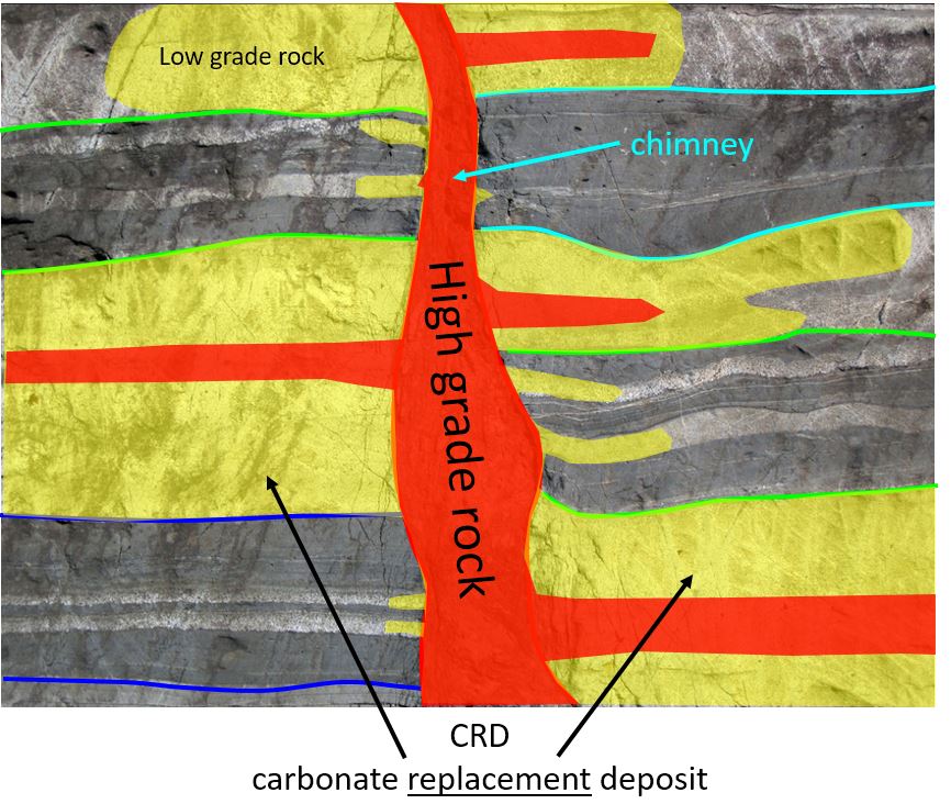
Here is a long section through an idealized CRD deposit (source - Pasinex Adana deposit (link) and Dr. Peter Megaw)


and here is an annotated long section through Taylor


It looks very similar to Peter's model, which is good, and you can see that there are 3 distinct styles of mineralization:
  1. CRD horizons - black dashed lines - these are dipping to the left (NW), and individual horizons are very extensive and have been drilled over lengths of >1km with relatively consistent mineralization. These are a nice steak.
  2. Chimneys - mineralization restricted to narrow (100m x 200m) vertical zones, with sharp grade contacts (i.e. outside of the chimney grade is very low). Think of these as a bottle of wine - all the good stuff is inside. 
  3. Veins - narrow, very high grade vertical structures. Think of these are those thin sheets of chocolate that you get stuck in desserts in fancy restaurants. They are great, but there is never quite enough.
Thee zones are very different (grade, style, orientation) and if you use a 'generic' control (i.e. assume that all the mineralization is horizontal), you may be over or underestimating the amount of mineralization in chimney zones. This is where infill drilling really helps to define the extents to mineralization.
  • Ante Mineralum
  • Post Mineralum


Source (link) - Photo of Fault with Fault Breccia by James S. John - I know it is the wrong rock type (Taylor is in limestone), but it was such a good photo showing bedding and faulting.

The Press Releases

This is where the holes were drilled


Blue = Jan 17th PR holes; red = Jan 26th PR holes
19th Jan - assays released from 7 drill-holes.
  • 4 holes (HDS-388, 397, 398 and 400) were drilling into the core of the Taylor deposit 
    • These are infill holes (i.e. drilling between earlier holes that hit mineralization)
    • Low risk drill-holes as the earlier holes surrounding them give you a good idea of what you will hit.
  • 3 holes (HDS-384, 390 and 392) looking for the NW continuation of the Taylor horizons. 
    • These are (relatively) high-risk holes, as the main Taylor horizon is very deep (>1000m) here.
      • Deep = expensive drilling.
    • Results were poor, the CRD zones are thin and low-grade. However, the holes did hit some shallow, high-grade vein mineralization.
26th Jan - assays from 3 drill-holes.
  • All holes were infill holes designed to better understand the Taylor deposit mineralization and to convert inferred into indicated resources. They won't have much impact on the overall tonnage of the deposit.
  • Holes intersected narrow high-grade zones, surrounded by lower grade mineralization - this could have an impact on reducing the overall grade and tonnes of the deposit.

NW Holes

Here is a section through the deposit. I've added scale bars so you can see how deep AZ are drilling.
Holes 390 and 392 hit mineralization at ~1100-1200m depth (it is probably costing them at least $200K/hole to drill to that depth).

CRD zones = red lines.

We can Also see that the 2 main Taylor CRD zones stop between holes 401 and 392. So it looks like resource expansion to the NW is limited as best. I can;t see them drilling more holes in this area, unless they are going to focus on the shallow, high grade veins.

Central Zone

Here we see the chimney effect, in the chimneys we get much thicker and higher grade material, and when you look at the results in more detail, we actually see that these thick zones are really several, narrower high grade (>5% Pb) zones surrounded by marginal grade rocks.

Please note - I've used lead to highlight the high-grade zones
Here we see the grade in the BEST HOLE EVER - look at how the upper high grade zone is essentially gone in the holes that are only 70m away. You can also see how there is drastic grade changes between holes as well - the narrow (10m wide) high grade zones appear to continue some distance (these are probably representing replacement of specific beds in the limestone - see images above) but the thick zones don't. So what do you do in this type of situation? You have 2 options:

  1. Cram as many holes into that area as possible that may significantly reduce change the size of this high grade zone, but would give some spiffy PR headlines
  2. Treat this area as a "Zone of Avoidance" - if we don't touch it, we won't break it approach - this leaves a nice chunk of inferred resources but preserves its virtue and make sure it stays nice and large (and relatively undrilled).


So, for me, I think Hermosa is a large base metal resource, but no more. The local communities have successfully prevented any mining or exploration activities from being conducted on public land (not just for Arizona Mining but for several other companies as well), and I can guarantee that the PFS and FS due in Q1 and the end of 2017, will show how robust the economics of the project are, but if you can't get permits, the zinc, lead and silver are going to stay in the ground.

3D model can be found here (link)

Lies, damn lies and metallurgical studies - part 2

We all like a great drill intercept, and we are blessed that exploration companies pander to our needs and desires, and as a result. we the investors, have built a symbiotic relationship with them. It goes something like this:

Junior company releases a hot drill-hole, we jump in and buy, 'cuz the project is good the management beautiful and honest. 

Deep down, we know that they are good, hard working folks, busy polluting lakes and rivers, pissing off and killing locals, just to satisfy the needs and desires of the retail investor to allow us to flick through a copy of the Robb Report and pick out our next car, house or spouse. God Bless 'em.

However, sometimes we get a few baddies, those companies that like to cheat a bit and rather than industriously explore the frontier exploration areas (deepest darkest Peru, the 'stans, or Ontario), they miraculously find a well drilled project, it is easiest and stick a few holes into the best bits, like our friends at First Mining Finance's Stripper-pole deposit project lake.

yellow > 0.4 g/t Au, orange > 0.8 g/t Au, red >1.2 g/t Au
I know they are metallurgical holes, and really important to do on a project that has already had 4 previous metallurgical studies done on it (1989, 2011, 2012 and 2013), but maybe they could have done a better job, I mean - WWAD?*


*WWAD = What would Avrupa do?

It is Exploration equivalent of Ice Ice Baby. Shamelessly ripping of a good song and producing something worse.....

And talking about lakes, only 75% of the deposit is underwater.
I've added some traditional Canadian fishes to make this image more sexy.
Fortunately, the Australians have Aquatic mining equipment
submersible drill-rigs (they never lose circulation)
aquatic loaders
Underwater dragline
submersible dump trucks
What First Mining are doing is outlined in the last technical report, they needed to take some more, representative samples so that they could better understand the nature of mineralization and hot to maximize recoveries, but as I've mentioned before, if a company ONLY focuses on the high-grade mineralization, which is often very different from the run of mine muck, it can distort the recovery assumptions, for example:

  • High grade ore may contain more free milling gold and require the plant to build a gravity circuit, or coarse gold that could be recovered by leaching
  • low grade ore may be refractory (i.e. encapsulated in other minerals) and may not be recovered through a gravity or leach circuit and require a finer grind.
This could lead to a mine building a plant that can only process material from a small proportion of the deposit and require may require 'upgrading' if the plant (increases CAPEX, mine down-time etc.) to process the ore that makes up the bulk of the deposit. All FMF had to do was drill a couple of short holes into the yellow zones so that they could conduct metallurgical studies on all the different ore-types and mineralization styles. They would have got the hot holes the market loves and adequately sampled the deposit.


Saturday, January 28, 2017

SolGold - Casabel Update

DISCLOSURE - I own shares in SolGold as I think it is one of the best porphyry projects currently being explored.

We have been receiving some news from SolGold about how drilling is progressing at Cascabel (link and link).

Summary


  • No surprises, the holes announced (18, 19 and 20R) hit copper mineralization where expected
  • Hole 18 is an infill hole = will return great grades but won't add many tonnes
  • Hole 19 and 20 are very conservative, with minor (50-75m) step outs from earlier decent grade holes
    • they appear to show that the porphyry is quite narrow (~250m wide)
I was disappointed that Sol Gold wasn't going to be a but more adventurous with their drilling and have one of the 3 rigs drilling a bit further away (e.g. around Alpala SE) to test the upside at Alpala - is it a series of medium sized porphyries or 1 enormous one.

Maybe next time...

Here are my officially bad (tm) resource calculations


So that isn't too bad, it will be interesting how these results compare to the official numbers.

You can download my 3D model and resource calculation spreadsheet from here (link), and you can e-mail me if you want the complete project.

Section 1 - Hole 18


Black bars = where DH have intersected copper mineralization in SolGold PRs
We can see that hole 018 is only 50m away from hole CSD-14-008 and CSD-15-014. We can then predict what it will intersect my predictions are:

  •  0.5% Cu and 0.5 g/t Au from 1000 to 1450m
    • including ~0.8-1% Cu and >1 g/t Au from 1050 to 1250m

Section 2 - holes 19 and 20R

Red line - approx. extents of porphyry mineralization
We can see that holes 19 and 20 are again minor step outs from earlier high-grade holes, and hole 19 hit mineralization where expected (i.e. at the same point where hole CS-16-017 hit mineralization), as did hole 20R. No surprises here. My prediction for hole 19 is:
  • 0.5% Cu and 0.6 g/t Au from 325.6 to 1161.5m
    • including ~0.6-0.8% Cu and ~1 g/t Au from 850 to 1161.5m
    • 325.6 to 850 will run around 0.4% Cu and 0.35 g/t Au
For hole 20 I'm not going to predict grades, but I think that Cu-Au mineralization will be intersected from 905.4 to 1450m, where it will pass very close to (less than 50m) hole CSD-16-016 that hit a nice high grade zone from 934-1301m that graded 1.34 g/t Au and 1.01 % Cu.


One downside is that the porphyry appears to be quite narrow (only 250-300m) wide, the best mineralization is very deep (750m depth).


Friday, January 20, 2017

Bulk Density - an overlooked part of a resource calculation

I touched on this as part of my series of posts on the Hermosa project, and I wanted to expand.

Tonnes = volume x bulk density

Companies spend a lot of time calculating the grade and the volume, but as we saw with Taylor deposit there have been a few cock-ups cause by not getting the actually density of the different rock that contains the metals you want.

Bulk Density is also specific gravity - this is the mass of a rock within a certain volume and is normally expressed as grams per cubic centimeter or tonnes per cubic meter.

For reference water has an SG of 1 which means:

  • 1 cm3 of water weights 1 gram, 
  • 1 m3 of water weights 1,000,000 grams or 1 tonne.

SG of different rocks - link
SG of different sulfide minerals - link

The SG value for a rock if affected by porosity (microscopic spaces between the grains), fracturing (faulting), weathering (removing minerals or altering them into 'lighter' clay minerals).

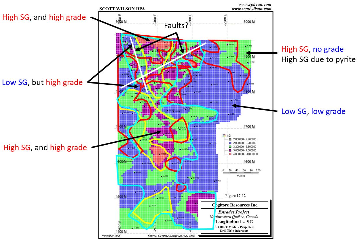
Why is this an issue? Here are a series of long sections from Galway's Estrades project in Canada. These images came from the November 2006 Technical reported prepared by Scott Wilson RPA for Cogitore Resources Inc.

Here are a series of long sections showing the distribution of each major economic element (there are sections for gold and silver but they constitute a very small part of the rock and won't impact the bulk destiny by any significant amount).

Zinc

Copper
Lead

Bulk Density
Here is an annotated version where I have drawn on (badly) the >1% Pb, Zn and Cu grade contours.


You can see that in general there is a reasonable correlation between grade (total sulfide content) and SG, but it isn't perfect. We can see that the Bulk Density (SG) varies from less than 2 g/cm3 (blue) >4 g/cm3 (a 100% difference). So you can see the problems that could be caused if you use a single bulk density value for a rock type or ore zone, or use an arbitrary values. 

Most companies have adopted the "take lots of samples" approach as collected bulk density measurements is cheap and quick and will allow you to accurately model the changes in the bulk density within a deposit.

However, if you see a company using single or average bulk density values (or mathematical formulas) in their resource calculations, it should make you stop and think for a moment as there have been some major and costly failures where companies haven't used the correct SG value.

One interesting technical question to ask - specifically directed towards Hermosa - is what is the correlation between sulfur assays and bulk density?


Friday, January 13, 2017

Hermosa - a summary

We seen over the past week a series of posts on Arizona Mining's Hermosa Taylor deposit that it has issues, and I apologies for being negative on this project but we are talking about a company that has market cap of ~$600M. They have sufficient funds to everything to the highest standards. For me, the most frustrating part is that they appear to have been careless (the manganese issue) and dishonest by 'erasing' references to 'clean' concentrates and decreasing recoveries and concentrate grades.

If I was a shareholder, I would feel that I was entitled to a honest reply from the company. Instead AZ management have gone into "ostrich" mode and buried their heads in the sand.

Manganese

The manganese question could tacked head-on. All they have to do is go back to the assay database and check see if the manganese is pervasive or just found in a few areas (i.e. close to the manto oxide zone). This would take a couple of days to do, and would have allowed them to state that the manganese was a local issue and by accident some of the samples used for preliminary metallurgical sample contained significantly more manganese than the majority of the deposit.

However, AZ management decided to take the mature approach. They removed the following statement from their latest presentation, but you can still find it in their Jan 7th 2016 PR (link).

Dec 7th Presentation - slide 6
and in the technical report

Page 6 - Oct 2016 Technical report - this statement is repeated on pages 7 and  94

I wonder if we will see an amended technical report with an 'updated' metallurgical section in the coming weeks?

Metallurgical Recoveries and concentrate Grades

I'm extremely concerned about the changes to the metallurgical recoveries and concentrate grades values in the recent presentations. They match the values in the technical report, so why where incorrect values used in the December 7th presentation?

The timing was a bit strange as the date of the presentation coincides accidentally with the announcement that they had raised $36M to develop the project (link)?

My concern is that maybe this was another careless mistake, like the manganese issue, and bulk density question. However, when you look at it, that is a lot of faux pas from a single company.


The Elephant in the room

I apologize for sounding negative, AZ have defined a lot of resources and control ~17,500 acres of prime exploration ground. They've done a lot of drilling, so why don't we have a look at where those holes are:

DO NOT CROSS THE RED LINES
Wow, all of the drill-holes are on private land? OK, I get it, permitting is much easier on private land, but AZ have been drilling Hermosa since July 2007 (funny fact - it took them 7 months to release the results (link*)), surely in that time they would have got a permit of two to allow them to drill in the lava public land surround the deposits?

I like the way (circled in yellow) they've had to drill these weird orientated holes, like tentacles of a perverted squid in a Hentai cartoon reaching out for a nubile young lass.

*press releases prior to this (link and link) were releasing assay results from the re-sampling of the historic ASARCO drill sample pulps. 

The question you have to ask is:

Why? It is reallly that hard to get a permit to drill a few holes in the Coronado National Forest?

If you can't get a drill permit, imaging the issues that they will face when they try and develop the project? I'm sure it will be easy, just like at Resolution (link, link or link)!

Well, at least they will have got someone on-board to buy the concentrate, but then again the observations from Ocean Partners are just words. they mean nothing as we have to be realistic here, there is going to be no mining, and no concentrates being produced from Hermosa in the next 10 years.

up to 6 years just for the permits
and some fecking nimbys


Heck, if they want, I'll sign an MOU to discuss the precious metal stream....


Thursday, January 12, 2017

Hermosa - January Update

AZ released some spiffy new drill-results today (link)


When you look at the accompanying plan map, you can see why the results from hole 396 were good, and the other holes didn't really hit much, just a few narrow zone and veins, so we'll ignore them.

high grade zone circled in red
When we zoom in, we can actually see that hole 396 wasn't a huge intercept of medium grade mineralization but a series of narrower high grade (>10%) zones within a large zone grading between 2.5-5% Zinc.

Red >10% Zinc; Blue 2.5-5% Zinc
Hole 396 was drilled to follow-up on the thick intercepts in holes 333, 334, 335 and 374. When you step back you can see that there are a couple of areas where the mineralization is much thicker than everywhere else.

Central zone centered on hole 333, 334 and 396; second zone centered on hole 104
You can see that there are 2 distinct orientations to the zinc mineralization:
  1. Predominant - A series of sub-horizontal (dipping down to the left or northwest) zone related to rock contacts and the basal low angle fault.
  2. Vertical pipes (?) of base metal mineralization - most likely related to vertical faults being used as conduits for mineralized fluids.
This is important as for accurately calculating the resources you need to model each zone separately, with their own bias to the direction (search ellipse) that the mineralized intercepts are joined together to link adjacent drill-holes. This is important for fault hosted mineralization (the vertical stuff) as the fault zone could be very narrow (a few tens of meters) and very high grade.

Check out the copper distribution:


The copper appears to show a bit of zonation. the deeper mineralized horizon is much richer than the upper Zinc horizons, except where you see those nice thick intercepts, is that telling us something? You would expect to see elevated copper in the hotter parts of the system, deeper or nearer the source intrusive, but also where you get zones of weaknesses where fluids will be focused.

In Summary, a good hole, but not an unexpected one. I'll be guessing that we'll be seeing a lot more holes being drilling into this zone over the coming months.

If you want, you can download the 3D model from here (link).