Friday, July 28, 2017

Newrange gold - Pamlico

There have been several spectacular drill results released by Newrange Gold Corp from their recently acquired Pamlico project in Nevada.

June 19th (link)

fap

July 7th (link)

fap fap fap fap fap fap

Some cock-stiffening intercepts, and Newrange have nicely included some geo-porn

This picture was sponsored by Vaseline for dry and sensitive skin....
BTW - did you take that photo 4 years ago or forgot to change the time on that fancy new camera? It is true the ideas of march were unlucky in 44BC....

Summary


  • Massive grade smearing, gold is found in high-grade structures
  • No strong evidence for a large disseminated deposit.
    • Small areas of disseminated mineralization mineralization found where multiple structures intersect. 
  • Poor drill program execution - no real testing of structures, drilling appears almost random
  • RC drilling in a narrow structure gold deposit = cheap and nasty. Important controls on mineralization may be very hard to determine from small rock fragments.
  • RC drilling can also lead to significant grade smearing if not conducted carefully.
  • Next to the western hemisphere's largest munition storage facility
    • Negative: US military may not like explosives being next to its dumps
    • Positive: May be able to get cheap explosives
  • There has been significant prospecting around the project, there could be a chance to develop several several small high-grade zones into a moderate sized resource.


Rock Rant

I'm very disappointed with the drilling. Newrange are using RC drilling to explore the project. I understand that it is quick and most importantly, cheap, but you end up losing so much information.

The holes appear to be almost randomly orientated - what are they actually trying to drill?

They have the mapping and sampling from the ramp that identified 2-3 gold bearing structures.

red dashed line = traces of structures in the ramp
Why didn't they follow those along strike to see where they go? It looks like they have been very lucky, or do we have a forgiving, disseminated gold deposit?

Let us put the data through the de-intervalator:

ta daaaaaa!

Newrange have done a David Copperfield! All that beautiful gold has disappeared. Why?

You've guessed it, we have some beautiful examples of grade smearing. I would hate for a nEwsletter wrIter to have been confused by the press releases and think that there was potential for a high-grade disseminated deposit!

That big green hole is hole 17, my favorite:

  • We go from: 70.89m @ 3.57 g/t Au
  • To: 65.54m @ 0.396 g/t Au surrounding a couple of high-grade zones running
    • 4.58m @ 48.3 g/t Au
    • 0.76m @ 35.4 g/t Au

Note: 0.396 g/t Au = Waste (unless you're Coeur, when it represents a 'buying opportunity')

So to put it bluntly - 89% of the gold in 7.5% of the rock. No disseminated potential here, but it isn't all bad news, they have a ramp going into that zone, and so I wanted to understand the controls on mineralization.

Pam's varicose veins

From this I built a vein model to see if the thick hits were from wide, high-grade veins or some luck from drilling down the vein (so a wide apparent width). The veins were modeled by projecting the information mapped in the decline and linking them up with assays along strike.

Plan view 


So we have 3 principal veins

Holes drilled sub-parallel to veins = long intercepts!

The cool thing is, when you bring all those veins together, you get this:

Red box = area of thick >1 g/t Au intercepts


By building up a decent 3D model you can start to see how the pieces fit together. There is a small zone of >1 g/t disseminated mineralization where the 3 structures come together. The nice thing is that it is close to the ramp, which provide Newrange the potential to define a small tonnage "bulk sample" that they could extract and process to generate some news and maybe some loot.

Here is my Palmico model (link)

highest gold values where the veins come together, that's original
Sometimes you can do cool stuff when working in 3D and I feel that many exploration companies are missing a trick if they stay in Flatland (ask A Square) when looking at the exploration data.

District potential

This is what is interesting about Pamlico. in the initial drilling there hasn't been much evidence to support a large, disseminated deposit, but with careful, focus drilling (with a fecking core rig) Newrange may be able to define several small, high-grade zones that could hypothetically feed a small operation.

If you look at the entire district (and I am assuming that Newrange has most of it), you can see:

a metric feck tonne of veins

There are heaps of workings, following veins/structures for >1km along strike. There could be many, small high-grade zones there.


Thursday, July 20, 2017

the Tinka of sleigh bells

We have some more intercepts released from Tinka, the results were inline with my expectations and we can see that they have helped increase our officially bad resource by a few tonnes.


I've decided to include a ZnEq table so you can compare my resources against the number from the adjacent deposits to see how they compare.

Here are where the holes have been drilled


Tinka are trying to see how the South Ayawilca zone connects with the Central and West deposits.

Here is a section from South (left) to the Central deposit (right)


I've brought in the intercepts from the previous technical report, it isn't complete but it does illustrate that the lower zone appears to be thicker, and relatively consistent from the South to the central deposit. I also think that hole 74 and 75 just clipped the SE limits of mineralization and a couple of holes to the NW could get back into the thicker (>10m) higher grade (>5% Zn) zone.

It would be nice to see some holes to the SW as the 2 mineralized zones are coming close to surface. A few short holes could add some tonnes!

From South (left) to West Ayawilca (right)


A bit more complicated, do we have a fault between the 2 deposits. A few more holes will help....


Here is something interesting when I was looking at the copper data:


Is the copper data showing us a vector towards the heat source and root to the South and Central deposits?

Leapfrog views here (link)


Tuesday, July 18, 2017

Solgold technical report

A 43-101 report has appeared on Sedar for Solgold's Cascabel Project (link).

You can also download it from here (link).

I'm going to spend the next few days going through it and get back to you with some comments


Monday, July 17, 2017

Camino - Adriana drilled

We had some more results from the diamond drilling at Adriana from Camino minerals (link).

They are putting a nice spin on it, some nice banner headlines stating that they have massive amounts of lovely copper carefully buried under the hills and deserts of Peru.

Lets look at where they have drilled:

Camino Minerals - drilling the same shit twice (TM).
Nice and imaginative, right fecking next to the RC holes.


So we see that there are several wide-ish intervals of ~0.6-0.7% Cu,

Greeeeeeen everywhere, apart from that crappy blue zone at the end of hole 4
But they have some smaller, higher grade intercepts. To the Intervalator!!!!!!!

Now we are less environmentally friendly
Feck, the green has gone, all we have are a few narrow >1% Cu zones floating like beige jobbies in a sea of dirt.

When we looked at the first section it would be easy to draw some nice overly-optimistic copper blobs, imaging the fun we can have interpreting that!! So I asked the FAG to do it for me....


Hello FAG here, I'm going to be using a very hi-tech tool here from the geophysist's toolbox to do my interpretation.

I known, it should be red. please don't judge me...
Geological interpretation is just joining dots, remember:

No data ≠ No copper

You have to be inclusive as there are bonuses (like in candy crush) for linking as many points as you can together. Try and bring out your inner artist, and if you need inspiration, think Dali, Picasso or Normal Rockwell.

There are hundreds of ways make the biggest shape possible. Here is mine, I went for the decapitated Llama as the project is in Peru.


the small blue intercept in hole DCH-002 is a dingleberry.

Unfortunately, the intervalator ruined it, so but, how do you join up the high-grade zones? Maybe there is a clue?

A geologist in his field...


There is a geo-chappy standing on, infront of an old mine. Do the working look like they have exploited:

  • A vertical mineralized zones?
  • A horizontal mineralized zone?
  • hit the Pisco and gone crazy?


So, it looks like the old miners extracted copper from near-vertical mineralized zones. This is what I think is happening at Camino.

ohhhh, shite, I won't get a Christmas bonus for this one....

I've also looked at the type of mineralization, as Camino like to tell us how much of the copper is soluble in acid (i.e. oxides)

Message to Camino - well done, it only took 3.5 months to change the units from g(rams) to Percent for the acid soluble copper assays. Good Job!
There is still a lot of acid soluble copper at some quite impressive depths. Is this because of the Diva fault and is just local, or is the transition from oxide to sulfide mineralization extremely extensive? There could be a call for some early metallurgical testing just to see how much copper can be extracted from this transition zone as the data seems to tell us that it could be very extensive.


Wednesday, July 5, 2017

Tinka Update

In my earlier post (link) I made a mistake when calculating the resources, a simple excel error.


I accidentally multiplied the volume by the Zn cut_off grade so severely skewed the high-grade resources. It was amateur time and I apologize for such a stupid mistake. I've salso updated the Specific Gravity to 3.6 from the 2016 technical report by RPA. I had originally used 2.9 (which was an average from several similar deposits)

Here is the updated resource table, including the latest set of results


So I've updated it and included the new drill-holes, if we ignore my earlier inaccurate resource, we've increased the tonnage . I'm not going to do a full post as I'm trying to get my hands on the DH collars for the earlier Tinka holes to see how the 2 resources may connect!

There are what the holes look like

Add caption

Hole 69 was drilled ~50m away from hole 65 and shows that the lower manto looks nice an continuous, but the upper manto is much thinner and inconsistent.


Hole 70 appears to show an offset in the lower manto mineralization. This may be due to faulting or as I don't have the down hole survey data, I', not able to plot the holes very accurately, and the Zinc zones in holes may line up. The good news is, again we have a nice consistent Zn zone (with a high-grade core) that is open to the NW (right) and SE (left). A few holes here could add a lot of tonnes relatively quickly!


If you want to send me any abusive e-mails, which I fully deserve, please address them to:

teresa.may@gov.uk with the subject line - I like your leather trousers


Monday, July 3, 2017

Hole 23

DISCLOSURE: I own shares in Sol Gold.


Question: What is the easiest way to find a million ounces of gold!

Answer: Drill a hole through the guts of a high-grade copper-gold porphyry

Each of those squares measures 300m
Here is hole 23R from Alpala (link). It went straight through the core of the Alpala deposit. There is a lot of grade smearing going on. In reality they only drilled 474m of economic mineralization (>0.5% Cu and 0.5 g/t Au), with a spectacular high-grade heart grading >1% Cu and ~3 g/t Au.

Here are the updated official bad resources:

A nice jump-up in contained metal!
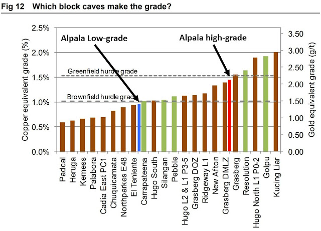
Alpala will be an underground operation, and here is an excellent summary on costs involved for block cave operations - link. Here are some comparative sizes of some of these projects:
  • Cadia: 1.5BT @ 0.47 g/t Au, 0.27% Cu
  • Hudo Dummit: 500Mt @ 1.66% Cu, 0.35 g/t Au
  • Resolution: 1.8Bt @ 1.54% Cu
Brown = brownfield projects; green = greenfield projects
When we look at the project listed in the figure above we can see that there are 2 types of projects:

Brownfield

  • Satellite, high grade deposits next to an active open-pit mine
  • Depth extension of ore-bodies that were mined by an open-pit but now is too deep to be mined from an open-pit

Greenfield

  • standalone development projects
The reason I highlight this is that the cost to developing a brownfield deposit next to an active open pit mine or going underground to mine the deeper part of the same deposit a lot cheaper than building a new mine one from scratch. This also means that brownfield projects don't need to be as large or as high-grade to be developed.

At the moment, Alpala isn't quite big enough or high-grade to be a stand-alone operation, a few more holes like 23R will help! However, this is where the other exploration targets come in.

From Sol Gold June presentation
At the moment, all drilling has focused on Alpala, let us have a look at Aguinaga.

the hair nicely outlines the Cu mineralization found in a porphyry
We are told that they plan to start drilling there later this year. From Surface mapping and sampling they found some nice juicy rocks at surface, that look very similar to what they have been drilling at depth at Alpala.


Here is Aguinaga and Alpala. What Sol Gold are drilling at depth appears to exist at surface at Aguinaga.


Imagine what would happen if they found another Alpala at Aguinaga?