Showing posts with label Nickel Mountain. Show all posts

Friday, September 13, 2019

Quick GGI update

PR from yesterday from Garibaldi (link), and I've updated the Leapfrog model with the results form holes 47 and 53 (link)

now some piccies

Hole 48

This is an infill hole, it is 16m from holes EL-17-09 and 10 and 10m from holes EL-17-14


However, the when we look at the lauded 44.5m at 1.2% Ni and 0.8% Cu we quickly see in reality this wide zone is really running ~0.5% Ni and Cu with the majority of the metals in the ~5m wide massive sulfide zone.


Hole 53


What we predicted, again, the massive sulfide zone was slightly wider than I had doodled in an earlier post.

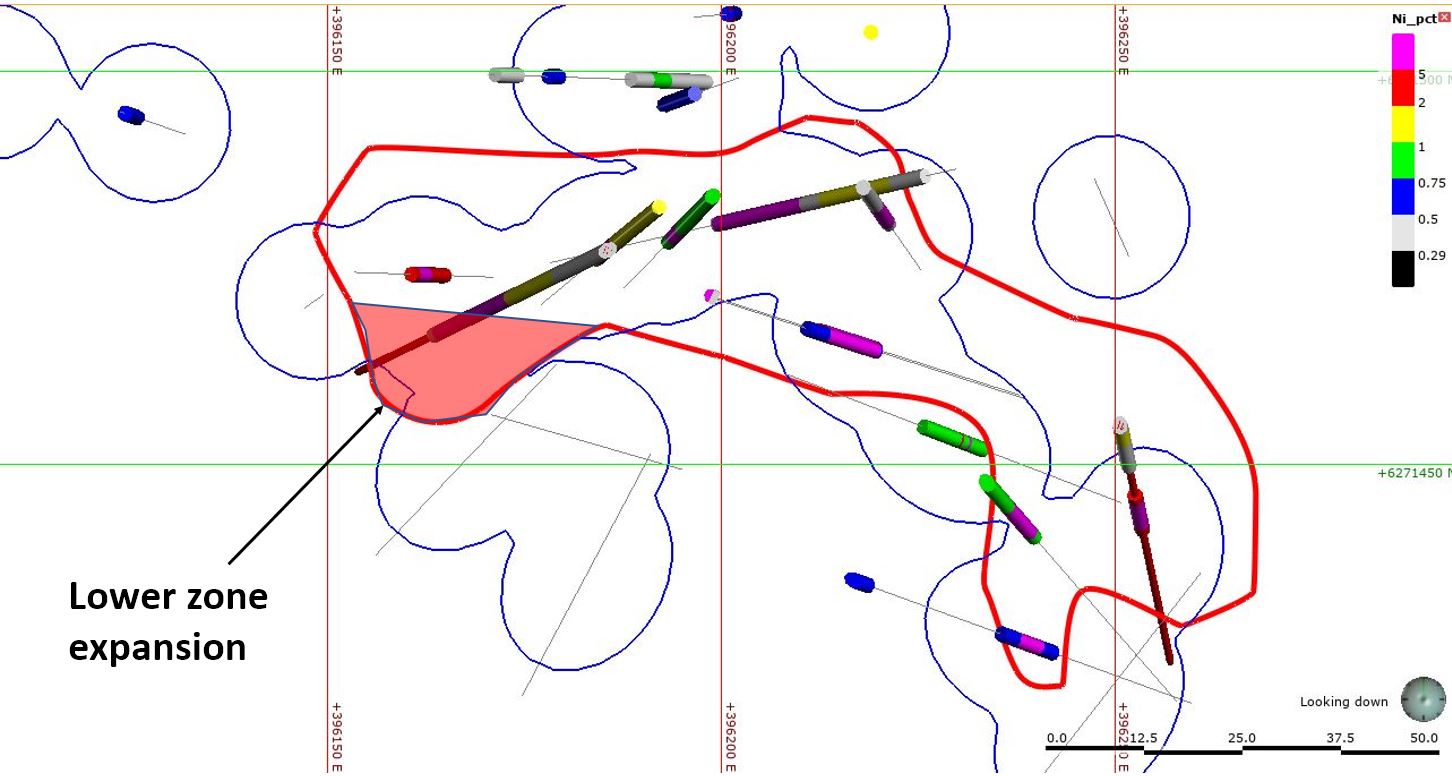
How do this change the lower zone massive sulfide footprint?

a bunion
Not by much.

So how big is Nickel mountain? Here is my modeled Ni mineralization


Which gives me an approximate size of...


As people got butt-hurt about me comparing Nickel Mountain with Voisey's Bay, here it is compared to a multitude of Nickel deposits (source - link).


So, it isn't, what you would call a tier-1 deposit

Thursday, August 22, 2019

Garibaldi - attack of the biscuits

Sorry for my tardiness, I was playing around with copper deposits.

We got a PR from our chums at Garibaldi Resources announcing the first of many few drill results from Nickel Mountain (link)

To the surprise of no-one, we didn’t get any decent maps with this PR, just a couple that re hard to read at the bottom of the PR - I couldn’t see where these new holes were located , could you?

but fear ye not, here they are....

OMG!!!!! both of them have targeted the Swiss Cheese Discovery Zone.

Let’s look at the holes in a bit more detail

Hole EL-19-47

This is drilling the eastern continuation of the lower discovery zone.

That hole was drilled a massive 15m from hole EL-18-16 and 24m from the massive sulfide hit in hole EL-18-24. Not really a massive leap of faith that would add millions and millions of tonnes to the deposit.

EL-19-53

This hole was drilled from the same platform as hole 47 but in a different direction, plunging into the heart of the known


Just 11.3m from the massive sulfides hit in hole EL-18-22


And 14.3m from the massive sulfides in hole EL-18-20…

Warning: the following image contains an “interpretation” involving one or more squiggly lines and maybe words, but definitely no numbers. Please sit down!


What is cool, is that you can join up the massive sulfide hits in several holes to work out an approximate outline of the Discovery Zone.

Isometric view looking SW. Red outline is my interpreted limit to sulfide mineralization
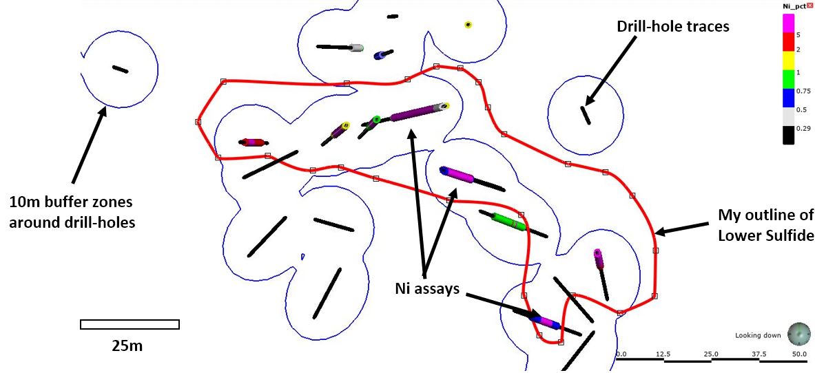
In Plan view, with some annotations and a scale


I added the 10m buffers around the drill-holes as it allows you to quickly see areas they haven't been drilled. 

A lot (20) of holes have penetrated the lower discovery zone defining a zone of massive sulfides that:
  • Dimensions of ~125m long, 15-35m wide and 5-10m thick (true thickness)
  • Or an approximate volume of 23,500 cubic meters
  • Or an approximate tonnage of 108,000 tonnes (using an SG of 4.6*)
*SG of Pentlandite (main Ni sulfide) is 4.6 to 5.0; Chalcopyrite (copper sulfide) is 4.1 to 4.3

So, Nickel Mountains isn't big, but there are a few areas where mineralization can be expanded

dashed green outlines - where mineralization appears to be open


Summary


Nothing new, just a couple of holes pushing the boundaries of mineralization by a metaphorical duck’s fart, and just for fun, here is the Nickel Mountain deposit compared to that tiddler, Voisey’s Bay.


Leapfrog viewer file can be downloaded from here

Friday, April 12, 2019

Garibaldi - The final cuts!!!!

Results!!!!!!!!!!!

Nothing special, nothing new, but after 4 months of waiting, Garibaldi have manged to publish the results from the final drill holes at Nickel mountain (link).

We get a smattering of regional exploration holes (all hit nothing), some hole exploring the new (i.e. not found by Silver Standard in the 1960s) and some nice promo-BS holes drilling down the guts of the NE and NW zones, which, I'm guessing weren't as good as expected and would have had no impact on the releasing the results.....


I'm only going to focus on the holes that were drilled in the NW and NE zones. A few holes have been drilled regionally, but they hit nothing, so we can forget about them. However, it would have been nice to have known what the holes were targeting (and maybe which geophysical anomaly), but that isn't the way that GGI operate.

You can find my Leafrog model here and I've also incorporated the surface samples form the Crevasse massive sulfide (link).

Northwest Zone - Explored by holes 36, 37 and 46.


Hole 36 
Drilled to explore for the southern continuation of the NW zone, it intersected a 42 cm zone of massive sulfides just 17m south of the DDH_05 drilled by Silver Standard in the 1960s that intersected 9.5m @ 2% Ni.

Looking small

Hole 37
Vertical hole drilled 22m south of hole EL-17-12 (18m @ 1.15% Ni and 1.09% Cu), that hit a couple of low grade zones.

Thick intercepts of nothing

Hole 46
Unsurprisingly with the poor results from holes 36 and 37, the final hole in the area (and the 2018 program) was a nice BS-hole, designed to drill right through the guts of the mineralization to get as long an intercept as possible.

Should have made the hole a bit steeper

The irony is, the hole did hit a wide zone of <1% Ni disseminated mineralization, but no high-grade and actually returned lower grades compared to adjacent holes (EL-17-05, 17-06,  and DDH_05).

Nice one guys!


NE and Crevasse Zone - explored by 5 holes.


I'm grouping these zones together as they all appear to be part of the same system.


We see that the massive sulfides are found at the contact between the E&L intrusion (purple) and the Hazelton sediments (lime green), and by some amazing fluke (GGI would never have deliberately designed them to be to be BS-promo holes) all 5 holes have been accidentally collared right in top of the of the mapped massive sulfides.

Unsurprisingly, all holes hit mineralization at surface, with each hole hitting a narrow (up to 1.5m core length) massive sulfide zone with minor (up to 18m) disseminated mineralization.

Should have drilled a metric-fuck tonne of 50m holes and got lots of intercepts

With nearly 40 holes drilled into an area that measures 250m by 125m, I am keenly waiting for GGI to commence a resource calculation for Nickel Mountain. I'm sure that they have enough information.


Joking aside, basically we see nothing new, the mineralization is restricted to small zones, there are areas where it can be expanded, but they are limited (and not everywhere as shown on the plan map accompanying the press release), but you need to remember:

Mineralization needs E&L Intrusion + Hazelton Sediments
Missing either = no mineralization

Why is this important - if GGI haven't rocks similar to the E&L Intrusion elsewhere on the property, then potential to discover additional mineralization is essentially zero.

Note - for the pedants


Sunday, February 24, 2019

Garibaldi - some results, at last....

Garibaldi, are you ill? The PDAC is weeks away, why did you suddenly decide to release the results from Nickel Mountain (link)?

This release only contained the assays from holes 30 and 33, but the text pf the PR told us that that holes 25, 26, 27, 28, 29, 31, 32 essentially hit nothing.

Remember:

  • drilling for stratigraphy/geology/ = we hit nothing 
  • Testing the shape of the host rock/intrusion = we're not sure what is going on
  • collecting (in)valuable information = we're not sure what is going on

You can get the 3D model from here (link).

Here is a plan map showing where the various holes are located.

Most of the holes are in the NW corner, the area where Ni mineralization was first found by Silver Standard in the 1960s.

It would have been nice to for Garibaldi to share with us the rest of the 2018 drill results, but they are still, errm, studying them.

It's only been 3-4 months, but I'm sure people will be happy to wait a few more weeks.....

So, without further ado, let's go through the holes:

Note: I'm going to ignore holes (25, 26, 28, 29, and 32) drilled outside of the areas of known mineralization, as they essentially hit nothing. I was intrigued by Hole 29, that drilled one of the famous VTEM anomalies  that Garibaldi had been squawking about for the last couple of years, but they hit nothing. The other reason is, we're not given any real info (e.g. maps or sections), probably because Silver Standard didn't do any work in those areas in the 1960s, about each hole, just a short descriptive paragraph.


Hole 27
This was designed to test the continuation of the NW Zone. The hole hit nothing, even though it came within ~20m of the massive sulfides hit in hole EL-17-08

We're told that it was an important hole "to help map out the extent and shape of the Intrusive complex". This is company BS-speak to save face, the hole as designed to hit the NW sulfide zone, but provided invaluable geological information hit nothing

Hole 30
This hole did actually get some mineralization. It hit 3 separate zones of Ni-Cu mineralization.
A zone at surface, which amazingly wasn't seen in hole 33 that was drilled literally centimeters (25 to be exact) from hole 30.
Mineralization, Consistent? Not!

However, it wasn't all doom and gloom. The hole hit a nice massive sulfide zone at 73m depth.

Some nice grade smearing....
Garibaldi nicely smeared the grade, we actually have a core 3.2m massive sulfide zone surrounded by a 6.5m low-grade halo. We can also see that the hole was drilled just 12m from the massive sulfide hit in drill-hole EL-18-23. So, not a massive step-out.


Hole 31
This was drilled to explore for the eastern continuation of the Discovery Zone. The hole was drilled just 40m away from holes EL-17-10 and EL-18-16 that both hit 9-10m of massive sulfides grading >7% Ni, but hole 31 hit nothing, not even a skid-mark. This shows how discrete the mineralization is.


Hole 33
The 'good' hole. This as drilled to explore for the northern continuation of the massive sulfide zone lower discovery zone.

50% of the Nickel in just 10% of the mineralized interval
Again we see massive grade smearing, a small massive sulfide zone in wide disseminated zone, and again we see this hole is only 14m from from previous massive sulfide intercepts.

When we look at the various sections we see that Hazelton group occurs as small, irregular pendants and blocks within the large Nickel Mountain Gabbro complex. Through all of this we have the sub-vertical E&L intrusion emplaced.


We can clearly see that the mineralization occurs at the contact between the E&L Intrusion and the Hazelton group, i.e.

E&L Intrusion + Hazelton Group = Nickel Mineralization
E&L Intrusion w/o Hazelton group = No Nickel Mineralization


I still think this is because the Hazelton group is contains Sulfur in the form of pyrite (hole 29 supports this). The E&L intrusion is Nickel rich, but sulfur poor and therefore can't precipitate Ni in the form of Pentlandite (an Iron Nickel Sulfide - formula ~FeNiS).

So we have, highly irregular contact between two small rock units that have formed a few small, high-grade irregular pods. Not exactly a geological situation that lends itself to forming a large deposit.


Thursday, February 14, 2019

Garibaldi BS

Happy Valentine's day, a time of friendship and goodwill.

So it is nice to see that it has been 106 days since Garibaldi last released any drill results from Nickel Mountain (link).

We were nicely told back in December (link) that they successfully completed the first full season of drilling, producing 11,573m of core.

So we are still waiting for results from 22 holes, or 2/3 of the program, which as GGI tell us:


Damn, you guys must be really slow if it takes you that long to interpret the results.....

Maybe we'll get something in time for the PDAC....

Saturday, November 3, 2018

Garibaldi - more results

Obviously, I was wrong with my final comment on my last post on Garibaldi:

Oops...
They hit some intervals of massive sulfide mineralization in hole 23 and 24, but again, with the maps provided, we can see that they are just 2 more holes drilled into the same area as before.


I've highlighted the collars in Magenta and the holes traces with a thick black line, and drawn a cross section through the massive sulfide intervals intersected by both holes. You can get the 3D viewer file from here (link)

In summary both holes were designed to explore for the Northern (Hole 23) and Southerm (Hole 24) continuation of the Central/Discovery Zone.


I apologize, this is a busy slide.

Hole 18-23 intersected a zone of low grade mineralization at ~125m depth, just below where you would expect the northern extension of the Main Zone to be (this hole is only 25m north of hole EL-17-14).

However, I'm intrigued by the massive sulfides at at massive sulfide zone at ~72m depth. It seems to line up with the massive sulfides hit in hole 41 and the surface outcrop of the Crevasse zone. To me, it looks like the Crevasse and NW zones maybe the same and connect down-dip into the Central/Discovery zone.

Still forming small pods
Hole 18-24, this was drilled ~15m south from hole EL-18-16 and hit massive sulfides at ~187m depth. It appears that the massive sulfide mineralization has been off-set (dropped down to the south) by a fault between these 2 holes. The good news is, it could mean that the massive sulfide zone is open to the south beyond hole 24. However, it isn't open in all directions as drill-hole EL-17-13 passed just 12m to the east and didn't hit anything. We see the same to the west (holes 18-15 and 17) where drilling has hit nothing of note.

Massive sulfide zone could be up to ~30 horizontal length

We've had 32 holes drilled into this area (7 historic, 25 by Garibaldi) measuring 360m by 260m (from extreme extents of the drilling) and all they have hit is a couple of mall, high-grade pods.

  • Discovery zone is the largest and is approx. 150m x 75m by ~10m thick in the core
  • The NW/Crevasse zone appears to be 120m x 75m by ~1-3m thick (if they join together).
The market is disappointed with this as we've been told that:


and shown


That the area that they are drilling is the WORST of the 4 VTEM targets known about since Aug 2017 (that is the date of the map above), yet we still haven't see a single hole drilling into anomalies A, B, C or the "Q" anomaly.

We still are waiting to find out the location and results from the final 16 hole (25 to 40), do you think any will be drilling on any of the other targets?


Sunday, October 28, 2018

Garibaldi - fecked?

1.7m.....
1.7m.....
1.7m....

The height of a fridge, or Tom Cruise

That is the thickness of the New Central Zone (link) according to a nice clarification PR released last Thursday and still hasn't managed to make it to their website.

We got depths, thicknesses, and coordinates, but no map, or any trace of any news from any of the 18 drill-holes (hole 23-40) that must have been drilled between holes EL-18-22 (results released on the 24th Sept (link) and the new zone discovered by EL-18-41 (link)

However, they included some hole info for EL-18-41 so we can see where it is, and you can get the 3D viewer file from here (link)

Correction - I made a mistake in the original viewer file, I put the massive sulfide zone at the bottom of the lower disseminated zone not the upper one. The updated viewer file is here (link). Not much changes.


OMG!!!!!!!! To the shock of no-one, it's located where every other hole has been drilled.I'm guessing they used that cunning geologist trick "let's just turn the rig around and start drilling in the opposite direction"

I jest, the hole was drilled below a new zone of massive sulfide mineralization exposed by the retreating ice field (I've called it the Global Warming zone, and it is a much cooler name than "New Central Zone").

Here is a nice cross-section


You can see that hole 41 hit the massive sulfide almost vertically below the surface outcrop. If this is the case the true width could be a little as 0.5m. Another section


correct section below

The corrected section doesn't change much. The new zone is still narrow, but now 30m rather than 75m below surface, but not exactly open-pitable.

This is quite a busy section, but note:
  1. the massive sulfides in hole 41 are ~75m 30m below the surface outcrop of the Global Warming Zone
  2. Hole 41 appears to be also testing the NW continuation of the Main/Discovery Zone beyond hole EL-17-02, and hit nothing, not even a mention of disseminated mineralization (assuming that this zone is ~horizontal).
  3. In the surface map they talk about a MASU (MAssive SUlfide) bounders in moraine. If you look at the topography, you can see that the Massive Sulfide bounder zone is downhill from the Global Warming zone. This shows that this zone is the source of the bounders and it is unlikely to be anything huge beneath the ice in this area.
To reiterate a point, GGI were very quick at rushing out a PR based on visual observation of the core from hole 41, yet we've heard nothing, not even a mention of anything from holes 23 to 40, why? They are obviously a lot worse than hole 41 and must be shite.

Wednesday, September 26, 2018

Garibaldi - Resource Update

Just a quick update. It was reported to me that my >2% volume wasn't accurately averaging/estimating the grade for this zone.

Thank you to Anon who alerted me about this.

It seems to be a 'feature' in Leapfrog Geo that for the highest grade grade-shell, it doesn't average the grades of the intervals occurring within the grade-shell, but uses the value I enter for the grade shell, in this case 2%.

What I have done is created an additional grade shell at 4% and here is the result:


It does have a big effect on the >2% mineralization. We have the same tonnes, but I think we have more accurate grades for the various zones.

Thanks to the kind person who pointed that out.

Tuesday, September 25, 2018

Garibaldi - feedback

As I promised a follow-up.

Here are the questions I asked:
  1. Where are the 2018 holes located?
  2. How big are the massive sulfide zones?
  3. Where can the sulfide zones be extended?
Hole Location

Oh look at that, all of the 2018 holes have been drilled into the Discovery zone, how imaginative.

BTW - holes 01 to 14 were drilled during the 2017 campaign
We also know that Garibaldi have already drilled 21 holes (link) during the 2018 campaign (hole 36 is currently underway according to the PR), but so far we only have the results from the first 8. What is interesting is that Garibaldi haven't included a map showing the locations of the other 12 holes that have already been drilled. I'll let you wonder why....

Magma Highways.......OMG...omg...mmmMMMmmm...spluuuge.

Ok, I've cleaned myself...


Deposit Size

So we have data for 29 drill-holes (7 historic and 22 by Garibaldi) which I've used to calculate the size of the various sulfide zones. Here is a 3D view (again, the model is here).

lots of holes, 2 small zones

I'm only looking at Ni in this analysis as there appears to be an ~2:1 Ni:Cu ratio (I'm working with summary data, so the ratio could be more complicated).


and here you go:


So, it is small and has a veeeeeeeerrrrryyyyy long way to go before it rivals Voiseys Bay (141Mt @ 1.63% Ni), but I'm guessing that the guys at Garibaldi will start to paraphrase Laozi in the upcoming press releases.

Expansion Potential

We're told this at the top of the section.

Sweeeeetttt

Open in all directions, with 29 holes exploring 2 small areas? Did all the holes hit massive sulfide mineralization? Why don't we look in detail.

The next set of figures are quite complicated. I'm drawing a slice through the 2 massive sulfide zones, to see where they are relative to the various drill-holes.


Discovery Zone

Here is a slice through the main zone mineralization. You can see that it has been well drilled (all 8 of the 2018 holes from the recent PR were drilled into this zone) and the holes are ~25m apart.

Left - annotated with drill-hole pierce points; right - Ni mineralization and DH buffers

I've added a 25m radius around each hole. This helps me show areas where mineralization could be expanded with additional drilling.  We can see a couple of areas that are open, to the west beyond hole EL-18-22 and to the east beyond hole EL-17-10 and 14.

Not quite open in all directions, but they could add a few meters more

NW Zone

Remember, none of the 2018 drill results targeted the NW zone.


We can see that this zone is open to the North and partially to the south. If will be interesting to see if any of the 13 holes that have been drilled and the results are pending are drilled into this zone. We can only speculate.

Additional Exploration Targets

Global warming to the Rescue!!!!!


Here it is in all its magnificence:


So we have an outcropping 30-40m long massive sulfide zone ~50m north of the Discovery zone. Has it been drilled, we'll have to wait and see.

How big could it be, we can only guess, but based on the fact that drilling has discovered 2 small massive sulfide bodies, and so it is likely that this will be a third, so small and inconsistent.

TL:DR version: This is what Garibaldi gave CAD $60K and 550,000 shares (CAD $1.03m) for. I'm looking forward to the next set of results, maybe we'll get them by Christmas....