Thursday, April 27, 2017

Camino Minerals - initial review

Camino have released some interesting results from the Los Chapitos project in southern Peru (link and link)

Summary

  • Good
    • Great result from hole CHR-002
      • but, we have grade smearing, outside the >2% zone, it drops off to 0.84% Cu, still good, but could be marginal for an open pit operation
    • Small, near surface oxide zone
    • Some other interesting targets to be tested around the property
  • Bad
    • It was a shame that they went with cheapo RC drilling option as it meant:
      • Hole 002 terminated in good copper mineralization
      • Holes 004 and 005 couldn't reach the extension of this zone.
    • Typical grade 'expansion' - the high grade (>1% Cu) is found in narrow zones surrounded by low grade (0.2-0.3% Cu).
  • Trench samples look good, but I'm skeptical of trench sampling as:
    • remember - you can bias them by sampling along a mineralized structure rather than sampling across it - the FAG will explain how you can 'improve' your trench results
Is water, or the lack of, going to be an issue?

They are drilling using an reverse circulation rig, so as they mention in the March 29th PR (link), so they will be drilling 200-300m/day and they will finish the program about now....

There are advantages and disadvantages with using an RC rig:
  • Advantages
    • Quicker - drill 200-300m per day compared to 50-100m for a diamond drill
    • A lot cheaper - ~50% of the cost (or even cheaper) of a diamond rig.
    • Doesn't need water - very useful in the Atacama desert
  • Disadvantages
    • Lower quality geological information
    • greater deviation - the holes drilled by Camino started at 45 or 50 degress, but steepened to almost 80 degrees at the end of the hole.
      • if you see any company not-surveying RC holes, that is a good sign that they don't know what they are doing and that the data from these holes are suspect as they can't accurately tell you where the mineralization is located.
    • bigger visual impact
    • require more site preparation - wider roads, larger pads
    • generally limited depth - ~300m depth is generally the deepest you can drill with RC
    • can have grade issues - smearing of grade, especially at the water table
However, for exploration, you have to balance cost, speed against geological information. We can see its limitations, CHR-002 stopped in >1% Cu mineralization, and with a diamond rig you could push the hole on (if you have enough rods) and see exactly how wide that zone is.

TL:DR: They started off good, but by using the wrong equipment, they have are not maximising the value they are getting from teh drilling (unless drilling magnetite-rich zones is the objective).

Geology Wank

Hole CHR-002, very good zone, but as the hole stoped in mineralization we don't know how wide it will be.

Follow-up holes 003, 004 and 005 intersected the upper copper oxide zone, but due to hole deviation, which is common in RC drilling, they all steepened and didn't reach the target. The irony is, this deviation was seen in holes 001 and 002 and I would have expected Camino to have modified the program accordingly, as they showed us that there was a very high probability that holes 004 and 005 would have steepened (go more vertical) and not hit the copper zone.

I'll explain it visually, I prepared this image form the original press release


  • Red line = planned hole trace (i.e. where they wanted the hole to go)
  • Colored line = actual trace of the drill-holes
  • Difference between these lines = the deviation
    • we can see that as the hole gets deeper, the hole steepens (becomes more vertical)
    • We can also see that the holes can only be drilled to around 300m - this is as far as this RC rig is able to drill at this project.
  • Magenta line = what I think hole CMR-005 will do - it will hit the upper zone (my guess ~20m @ 0.6% Cu) and not reach the copper zone.
This is from the latest presentation

bendy drillholes
Look how much blue (0.1-0.3% Cu) is included in that 44m zone grading 0.86% Cu!

so that makes them 0 from 3

So you can see how much the holes are bending by (up to 20 degrees), and that makes it hard for the company to hit the planned targets, which is the reason why holes 004 and 005 missed.

You also need to think about the how the mineralization occurs, is it:

  • flat lying bodies
  • Steeply dipping narrow zones
  • large stocks
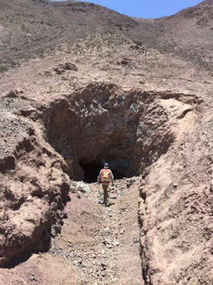
When we look at the presentation they show us some photos of some old workings.


They look to be nearly vertical, indicating that this how the mineralization occurs at Adriana.If the deep mineralization hit in hole 002 is vertical, then that zone may only by ~ 40m thick.


I think That Camino need to rethink their drilling strategy! They need to get some diamond rigs up there to answer questions on controls and size of mineralization. Continuing to drill RC-holes will start to reduce the value the company obtained from hole 002.

I've created a quick model of the drill-holes with their sections, so you can see how all the holes relate (link).

Look at how the Magnetite rich zone changes between sections...

Trenching results

Hello, FAG here.  Camino have given us some nice photos of some green-stained rocks in the Atacama.

Clouds!!!
Azurite skies...
and some photos of some old workings

Mein Mine

I've annotated the mine photo to show how you can get Maximum Impact (tm) results from trenches.


We have 2 trenches

  • Trench 1 - running parallel/along with the copper zone
  • Trench 2 - running perpendicular to the copper zone
Which will give the 'best result' for your press release?
  • Trench 1 = 30m @ ~1% Cu
  • Trench 2 = 3-5m @ 0.6-1% Cu
The question you need to ask is:


Mineralization

This was covered in the IKN post, so I've just included a image of a simplified mineralization zoning in a copper deposit


So, the upper zone is primarily oxide material, it may have some native copper and copper wad that is insoluble accounting for the 25% of the material that isn't acid soluble.

However, the lower zone is high-grade, contains only 25% soluble material, I wonder if this hole hit the enriched zone and we have a lot of Chalcocite.

Saturday, April 22, 2017

Grade smearing - Barkerville

Barkerville, that name seems familiar....

The big, fierce black dog is made to glow in the dark using phosphorus, chases a man, who runs in great fear and dies of an apparent heart attack?

ohh, crap, that was Peter George's crowning glory with "potential to host 40-90Moz of gold" (link, link and link).

So, you have a project and a company (the faces have changed but the name is the same) that had been pulled through a river of crap over a dodgy technical report. You would think that they would be extra specially good, and they wouldn't do some massive grade smearing, from a few narrow, ultra gfg*-grade veins and come up with a massive intercept that cause geologists to faint as their blood rushes to other parts of their bodies (i.e. not their geo-pick hand.....)

who ruined that picture of a gold sample with some yucky gurl's boobs?

*gfg = geologist's fantasy grades - think of these as Scarlett Johansson** - she exists, but there is no chance you'll ever date her, but you'll be happy to sell your mate's testicles just to have the opportunity to lick her armpit

**some people may not like SJ, they are probbaly the same people that say "I prefer silver over gold". They are wrong, and should be immediately disowned.

Holy shit, they've just raised $12.5m by flogging a 0.75% NSR on a Cariboo to Osisko.

that is one expensive Ungulate, i'm guessing that Osisko bought the balls...
Crap, wrong PR, this is the one (link) I want to talk about....

Sweet holy jebus, 54.4m @ 19.2 g/t Au - that is US$800/tonne rock, let's start mining now...

*sigh*

Let us look beyond the Uber-high grade intervals, like:
  • 0.5m @ 272 g/t Au
  • 0.85m @ 760 g/t Au
  • 0.5m @ 64.2 g/t Au
  • 0.5m @ 42.8 g/t Au
  • 1.5m @ 65.4 g/t Au
  • 1.15m @ 15.8 g/t Au
and look but what is the grade for the other 49.5m that they don't report? What does that run?

2.5 g/t Au

Yes-sirree, just a teeny weeny 87% drop. I mean, that is still a decent result, but it shows that 87% of the gold is in just 9% of the drill-hole.

Look at the moose, 9% is equal to it's back legs.

Grade smearing is endemic in exploration companies, heck, why didn't they make it 1044m @ 1 g/t for shits and giggles?

Taylor question

I want to ask you all a quick question, I mentioned that the different ore zones at Taylor have different recoveries.

If a deposit has very poor recoveries, should it still be allowed to state it's resources?

I've only included the Zn recovery as it forms the basis of my question.


We can see that they get very poor recovery (2.2%) from the single metallurgical sample* from the Scherrer zone.

*for the case of semantics I'm going to assume that this single sample is representative for the entire 14.3Mt resource for the Scherrer Zone.

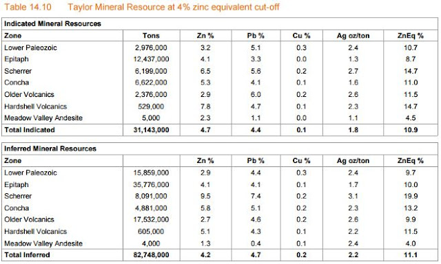
According to the Taylor resources they have calculated that the Scherrer zone contains:

  • Indicated Resources = 6.2Mt @ 6.5% Zn, 5.6% Pb, 0.2% Cu and 2.7 oz/t Ag or 14.7% ZnEq
  • Inferred Resources = 8.1Mt @ 9.5% Zn, 7,4% Pb, 0.2% Cu, 3.1 oz/t Ag or 19.9% ZnEq


It is (according to table 14.10) the 'best' zone in the entire deposit. However, the zinc recovery in the Scherrer zone is 2.2% (table 13.5 in the PEA), is this zone still good enough to be called 'ore'?

Let us recalcalculate** the ZnEq% for this zone:
  • Ind Res = 6.2Mt @ 6.5% 0.143% Zn, 5.6% Pb, 0.2% Cu and 2.7 oz/t Ag or 8.3% ZnEq
  • Inf Res = 8.1Mt @ 9.5% 0.209% Zn, 7,4% Pb, 0.2% Cu, 3.1 oz/t Ag or 10.6% ZnEq
**I've only applied the recovery percent to the zinc grades due to a massive bout of laziness

So this now takes the Scherrer zone from being the best zone to the worst (I'm ignoring the andesites as they are so small) zone. It is still economic to mine, but this is a quick demonstration for why I believe that companies should be using RECOVERABLE metal grades when they calculate equivalent grades.

Or put it another way, imagine that AZ spent ~$400M to build the mine, they are focusing on mining the 'best' ore, which according to the resources is the Scherrer Zone. They start mining, sending ore to the mill and suddenly find that all the zinc is disappearing to the tailings dam, this will cause a few problems like:

  1. Losing 40% of their revenues
  2. Possible environmental penalties as there may be quite strict limits on the amounts of lead and zinc that could be discharged to the tailings pond
  3. those fun, high confidence inducing press releases stating that "the ore is more challenging than expected", "processing difficulties", "additional test-work required" and the like.
It sounds like I'm picking on AZ, I'm not, I just though that this was a nice and easy example of a common practice in the exploration industry, and AZ provided some decent data to show it.

Thursday, April 20, 2017

Arizona PEA - quick comments and questions


So we have the Taylor PEA, it is lovely, beautiful and highly profitable. I've actually started sleeping with it, so I can absorb its awesomeness while I'll sleep, but sometimes every silver lining has a black cloud.

Summary:

  • Bye bye Central, it was nice to know you
  • They managed to get virtually all of the infrastructure onto the private land, but there appear to be a few Achilles's heel
    • water pipes need to cross the public land
    • they'll need to upgrade access roads and probably power-lines that cross the National Forest Land. It could be hard to get easements
  • The recoveries used in the PEA look unrealistically high, especially as the ore close to surface has lower recoveries.
    • the good ore is deep, so the first few years production could generate 10-15% less revenues, what knock-on will this have to the NPV, IRR and payback period?
I'll pass-over the fact that they are going to dump a load of tailings on top of the Central deposit (table 14.10), and ignore that Central has been on a the mango diet that has allowed it to shed an unsightly 60Moz from slimmed down from (table 14.19) a portly 200 Moz Ag to a sprightly 140Moz. I'm guessing that mango is laxative....

Do you like the way that AZ have squeezed everything onto the private land. That was some impressive origami, they managed to get everything on squeezed into the private land.

I've added the outline of the central pit
It makes for nice and easy permitting, just a few permits for water discharge, explosives and the like, but it does mean that they will have nearly 300 feet (or 100m) of dry-stacked tailings above the main production decline and shaft, and as they don't have enough land for everything, so unfortunately, Hermosa had to go and get buried.

However, they didn't quite get everything onto the private land, just a few irritating water pipes from the various water wells that they need to supply water to the mining operations. They couldn't drill in the public land so a couple of tubes will be fine.

red circles = where there is infrastructure on public land
I'm going to ignore the work required to upgrade access roads to site and the fact that there are several public forest service roads that cross the private land to get to the National Forest land on the other side, I don't if Arizona mining can prevent access, or if they will need to build new roads to bypass their property.

But, I'm confused, I was looking at the numbers in table 22.2 (page 215), as I was playing with the numbers, and I was checking the recoveries against the results of the metallurgical test-work.


You can see that the projected recoveries vary by zone, which is perfectly normal, we have a different amounts and types of lead, zinc and silver minerals. The very poor zinc recovery in the Scherrer zone is because the zinc is in silicates, not sulfides, and cannot be recovered through flotation.

However, as you know, I like to check the following:

  • How do the grades of the metallurgical samples compare to the overall resource
    • here we have a nice range, from 2.5% - this is going to be close to the cut-off grade, i.e. the lowest grade material that can be mined economically.
  • We can also see that recoveries increase with grade
    • This is also very typical
  • Are the recoveries used in the financial model in-line with the results received from the various metallurgical tests. Recovery values used in the PEA
    • Zn = 92.7%
    • Pb = 95.4%
    • Ag = 92.4%
Here are some nice pictures to show how they compare against the projected metallurgical recoveries (tables 13.5, 13.6 and 13.7) reported in the PEA.


I've added some nice, thick red-lines to show the recoveries used for each metal used in the recent PEA. You can see that only the Epitaph ore have recoveries that match the numbers used in the PEA, for the other zones they are, in some cases a lot lower. This is where the different zones are located:

Taylor ore-zones
Is this a problem? No, if AZ are only mining ore from the Epitaph zone. Their plan is to mine 60.8Mt over 23 years, so how much ore is there in the Epitaph Zone?

Table 14.10 from the 
So, if we take all of the Indicated and Inferred resources, we have 48.2 Mt in the Epitaph zone, but that leaves us with a small, 12Mt short-fall.

Where is this this material going to come from, and why is it important?

  • Manto zone - contains oxides, won't be mined
  • Scherrer zone- low Zn recovery, unlikely to be mined
This leaves the Concha zone, which is closer to surface, therefore require less decline and shaft construction (reducing costs), but the issue is, it has lower recovery, and if it is mined first (as it is close to surface), it will means that for the first few years, they will be getting lower recovery, and therefore lower revenues, which is not what you want.


Thursday, April 13, 2017

SolGold Update

DISCLOSURE - I own shares in Sol Gold. I'll try to make this post unbiased, but I want everyone to buy lots of shares so that I can make some money!

Over the last couple of weeks we've received the results from holes 19, 20R and 22 (link and link).

Summary

TL:DR version: Inline with expectations
  • Economic (>1% CuEq) mineralization is deep (~600m depth)
  • Hole 19 - drop-off in grade, as you move away from the core of the deposit (hole 16)
  • Hole 20 - clipped the edge of the deposit, didn't get much.
  • Hole 22 - Inline with expectations - >1% zone is quite narrow (100m core length)
They are having drilling issues - several holes lost before reaching target depth, and have changed contractor to resolve them.

I'm concerned about grade-smearing. When you separate out the high-grade zones, you are often left with wide-zones of much lower grade (sub-economic?) mineralization.
e.g.
  • Hole 22 - 730m @ 0.52% Cu and 0.23 g/t Au becomes
    • 100m @ 1.1% Cu and 0.57 g/t Au
    • 630m @ 0.43% Cu and 0.176 g/t Au
  • Hole 19 - 1344m @ 0.44% Cu and 0.28 g/t Au becomes
    • 552m @ 0.68% Cu and 0.45 g/t Au
    • 792m @ 0.27% Cu and 0.16 g/t Au
This shows we have a high-grade (>1% CuEq) core surrounded by lower grade mineralization, which is normal for porphyry systems.

TAG Officially Bad (tm) resources

  • Au - increased to 4.74Moz (542Koz or 13% increase)
  • Cu - increased to 1.7Mt (198Kt or 28% increase)
looking good...
The key is going to be the cut-off grades that are used to calculate the resources.

Predictions

  • Hole 21 - 925m @ 0.5% Cu, including a 400m >0.6% Cu - hole only 100m from hole 16, whihc hit a lot of good stuff
  • Hole 23 - being drilled, target between holes 16 and 19, so I'll expect
    • 200m >1% Cu and 1 g/t Au (@ 1,000m depth), within a 1000m zone of 0.3-4% Cu and 0.2-0.4 g/t Au
  • Hole 24 - keep an eye on this one, 3 scenarios (2 good and 1 bad)
    • Gets not much as it is drilling the peripheral part of the Alpala porphyry (i.e. lots of pyrite and not much else)
    • Drills deeper and hits the continuation of the Alpala porphyry
    • Drilling the peripheral part of the mineralization mapped at Malte Creek
  • Hole 25 - being drilled ~100m south of hole 19, so I'm estimating
    • 600m @ 0.3% Cu and 0.2% Au
    • drilling below hole 003 that hit a couple of narrow zones @ ~0.3% Cu and 0.1 g/t Au

The Good

Hole 19 hit reasonable mineralization, inline with what you would expect when you are drilling away from the high-grade core in holes 12 and 16. 

left = split assay results; right = super duper PR assay results
Hole 24 is going to be key, from the description (lots of pyrite and trace chalcopyrite and bornite), it suggests that it has intersected edge of a porphyry, but is it:
  • Part of Alpala system - they've extended it by >1km, which is huge, this could move Alpala into a >10Moz Au deposit
  • If it is associated with Malte Creek target - a separate, smaller Cu-Au system. Good.
  • If it is the distal part of the Alpala system - nothing changes
Gut feel - the middle one, we'll have to wait for the results to see what grades they get.

The Bad

Hole 20 appears to have clipped the edge of the Alpala system. Even though the hole was lost, I doubt that it would have got much more, so it basically tells us that the exploration potential to the east is less than thought.

left = split assay results; right = super duper PR assay results

I did enjoy the lip-sticking (applying lipstick to tart up some average results), done by the IR department, but Hole 22 (designed to see if the Cu-Au zones goes to surface) was a classic Playtex (tm) hole - looks great from afar, but once you get it open, everything disappears.

geoporn is always crap
However, the results from both  are what I would expect from holes that are drilling the edge of the system. We are seeing a gradual decrease in Cu and Au grades away from the center of the system (around hole 16).

left = Copper; right = gold
you can download the 3D view from here (link)

The Ugly

Sol Gold are drilling 1500-2000m drill-holes. So each hole will take 2-3 months to be drilled (I'm assuming 800-1000m per rig each month). You can now see how important it is to use decent drilling contractors, as you don;t want to have invested >$100K and more importantly time into a hole that is lost before it hits the target!

Losing a couple due to poor ground conditions is expected, but the fact that Sol Gold tell us that they have changed contractors suggests something more - maybe they were using old equipment and inexperienced drillers?  

Conclusion

When you split out the high-grade intervals you see that the best mineralization is deep (starting at around 600m) with a high-grade core that grades outwards into lower grade mineralization. For me, the key is to keep your eye on the 0.7% CuEq contours that SolGold put on their various sections. Fe me, this is a reasonable proxy for the economic limits of mineralization. If you carefully check Figure 6, you can quickly see the disconnect between the long mineralized intercept reported in hole 22


So essentially SolGold have given you a quick way to check their results and ignore the PR headlines and look at what the data is telling you.

What I would like to see

Some work on the other targets, it would be nice to know when they will be thinking about drilling the other targets. Alpala is now a mature exploration project and the new results aren't as flashy as earlier ones and people will start to get Alpala fatigue. It will be nice to have a rig exploring adjacent targets, as Sol Gold could find higher grade zones at surface where there will be amenable to open-pit mining.


Monday, April 10, 2017

Arizona Mining PEA review

So, a few days late we got the PEA summary PR. Over the next month or so we should expect them to upload the complete report to SEDAR.COM and maybe a copy on their website in the next 45 days see bottom of page 8).

There is a lot of information in the press release, and it is a taster to what we will see in the full report that will be released around mid-May.

Summary:

  • Robust numbers
    • NPV $1.26B
    • IRR 42%
  • Cost per tonne looks inline with other operations @ $48.08/tonne
      • Fresnillo = $43.93 tonne
      • Saucito = $36.75/tonne
      • Cienega = $55.49/tonne
  • All infrastructure will be within the Patented Trench concessions (i.e. the private land)
  • Initial production planned for 2020, but will take 3 years to ramp up to 10,000 tpd
    • year 1 ~4,000 tpd
    • year 2 ~7,000 tpd
    • year 3+ - ~10,000 tpd
  • According to the PEA - they will commence mining in Q4 2020, or 42 months from now
    • ground breaking will start in 8-9 months, before the completion of the Feasibility Study.
    • This is very aggressive

Questions

At this stage, we don't need to focus on the rocks. Any issues (e.g. Mn) can either be engineered out or they take a penalty charge at the smelter (i.e. increased CAPEX or decreased revenues). My initial questions are?
  • What permits and easements do they need to bring services to the mine (electricity, access)?
    • I know that the project will be on private land, but getting things to and from the mine site will require road upgrades and power-lines crossing Forest Service land?
    • what local opposition will there be to this?
  • The biggie - if they are going to commit to an aggressive development timeline, won't they need to have something more than "keen, ongoing interest in our future concentrates"?
  • What impact would (if they do ahead with it) a silver streaming deal do to the economics of the deposit?
When the PEA is released I'll be looking at the surface footprint and see if they have included all infrastructure. Occasionally they include all the important stuff (mine, waste dumps, tailings dams etc.), but miss off mine offices, service yards, storage areas etc.

Concerns

The timeline is aggressive, I'm going to call it a 'perfect' timeline, assuming that all parts of the process run to the minimum  - no opposition, no delays and Mr. Murphy goes on holiday for 3 years. I'm not sure that this is achievable, as they have to raise money (a small $457M), sign contracts, obtain permits, build declines, mills, roads, shafts etc.

Metal prices are relatively high:
  • Silver = $20/oz
  • Zinc = $1.10/lb
  • Lead = $1.00/lb
The other big concern I have is the comment that they can raise significant funds via selling a silver stream.
  • Raise $200-350M selling the silver - normally done at $5/oz
  • silver represents 15% of the mine revenue @ $20/oz
  • At $5/oz, this decreases to:
    • $27.5M from $110M, or decreases the revenue by 12%
  • what impact will this have on the IRR, NPV and payback period?