Sunday, February 24, 2019

Garibaldi - some results, at last....

Garibaldi, are you ill? The PDAC is weeks away, why did you suddenly decide to release the results from Nickel Mountain (link)?

This release only contained the assays from holes 30 and 33, but the text pf the PR told us that that holes 25, 26, 27, 28, 29, 31, 32 essentially hit nothing.

Remember:

  • drilling for stratigraphy/geology/ = we hit nothing 
  • Testing the shape of the host rock/intrusion = we're not sure what is going on
  • collecting (in)valuable information = we're not sure what is going on

You can get the 3D model from here (link).

Here is a plan map showing where the various holes are located.

Most of the holes are in the NW corner, the area where Ni mineralization was first found by Silver Standard in the 1960s.

It would have been nice to for Garibaldi to share with us the rest of the 2018 drill results, but they are still, errm, studying them.

It's only been 3-4 months, but I'm sure people will be happy to wait a few more weeks.....

So, without further ado, let's go through the holes:

Note: I'm going to ignore holes (25, 26, 28, 29, and 32) drilled outside of the areas of known mineralization, as they essentially hit nothing. I was intrigued by Hole 29, that drilled one of the famous VTEM anomalies  that Garibaldi had been squawking about for the last couple of years, but they hit nothing. The other reason is, we're not given any real info (e.g. maps or sections), probably because Silver Standard didn't do any work in those areas in the 1960s, about each hole, just a short descriptive paragraph.


Hole 27
This was designed to test the continuation of the NW Zone. The hole hit nothing, even though it came within ~20m of the massive sulfides hit in hole EL-17-08

We're told that it was an important hole "to help map out the extent and shape of the Intrusive complex". This is company BS-speak to save face, the hole as designed to hit the NW sulfide zone, but provided invaluable geological information hit nothing

Hole 30
This hole did actually get some mineralization. It hit 3 separate zones of Ni-Cu mineralization.
A zone at surface, which amazingly wasn't seen in hole 33 that was drilled literally centimeters (25 to be exact) from hole 30.
Mineralization, Consistent? Not!

However, it wasn't all doom and gloom. The hole hit a nice massive sulfide zone at 73m depth.

Some nice grade smearing....
Garibaldi nicely smeared the grade, we actually have a core 3.2m massive sulfide zone surrounded by a 6.5m low-grade halo. We can also see that the hole was drilled just 12m from the massive sulfide hit in drill-hole EL-18-23. So, not a massive step-out.


Hole 31
This was drilled to explore for the eastern continuation of the Discovery Zone. The hole was drilled just 40m away from holes EL-17-10 and EL-18-16 that both hit 9-10m of massive sulfides grading >7% Ni, but hole 31 hit nothing, not even a skid-mark. This shows how discrete the mineralization is.


Hole 33
The 'good' hole. This as drilled to explore for the northern continuation of the massive sulfide zone lower discovery zone.

50% of the Nickel in just 10% of the mineralized interval
Again we see massive grade smearing, a small massive sulfide zone in wide disseminated zone, and again we see this hole is only 14m from from previous massive sulfide intercepts.

When we look at the various sections we see that Hazelton group occurs as small, irregular pendants and blocks within the large Nickel Mountain Gabbro complex. Through all of this we have the sub-vertical E&L intrusion emplaced.


We can clearly see that the mineralization occurs at the contact between the E&L Intrusion and the Hazelton group, i.e.

E&L Intrusion + Hazelton Group = Nickel Mineralization
E&L Intrusion w/o Hazelton group = No Nickel Mineralization


I still think this is because the Hazelton group is contains Sulfur in the form of pyrite (hole 29 supports this). The E&L intrusion is Nickel rich, but sulfur poor and therefore can't precipitate Ni in the form of Pentlandite (an Iron Nickel Sulfide - formula ~FeNiS).

So we have, highly irregular contact between two small rock units that have formed a few small, high-grade irregular pods. Not exactly a geological situation that lends itself to forming a large deposit.


Friday, February 15, 2019

Anta Kori Update

I haven't been following Regulus to closely for the last 6 months, but I decided to compile the new drilling data (link and link) and see what they have been finding, and how the new drilling may impact the overall resources for the project.

Background blurb:

The original resource for Anta Kori was done waaaaay back in 2012 for South Legacy, but if you read through it, it is very light-weight, we don’t get any information on:

  • Where the resources are located – not even a simple map
    • Where are the open-pitable resource located?
    • And the underground resource? Where is it, how will they mine it, from the bottom of the pit?
  • No images or sections of the block model showing grade distribution etc.


It is a crap report, a quick and dirty resource calculation. I especially hated the way that they used every metal under the sun to calculate the CuEq grades for the various resource cut-offs.

In essence, it is a crap report.

However, table 14.7 did give a breakdown of the global resources (i.e. not constrained by property boundaries). I wanted to see if I could create a base model from the historic data that could match it, with the idea that I could bring in the recent drilling results and see what happens.

However, I have a big problem:


Look at this table in detail, start with the first row. Write out the total contain metals in full (i.e. including the “0” in the column headings. Do you get:

  • 519,541,000 tonnes or ~520Mt that contain
    • 4,429,000 lbs of copper – just 4.4Mlbs
    • 126,335,000 oz of gold – 126 million ounces of gold 
    • 3,989,155,000 oz of Silver – just under 4 billion ounces of silver
    • 10,598,000 lbs of Moly
    • 572,695,000 lbs of Lead
    • 2,172,276,000 lbs of Zinc


Damn it, Southern Legacy found South America’s largest gold deposit and second largest silver deposit. Who gives a shit about copper with all that lovely gold and silver.

Unfortunately, as I’m an idiot, I decided to try and work out WTF was going on, brought the data into excel and calculated the amount of contained metal for each element (basically took the tonnage and multiplied it by the grade provided).

And you get….


There are some slight differences:

  • ~30% reduction in contained copper (assuming the table was referring to Billions pounds of copper).
  • ~45% increase in gold (I have assumed that they put the contained gold under the contained silver column)
  • Silver, lead and zinc stay the same (assuming that the contained silver was put under the contained gold column)
  • ~80% drop in contained Moly


Generally, very painful news, but the extra couple of million ounces of gold is a nice bonus.

The silly thing is, table 14.5 that splits the resource into Open Pit and underground areas, i.e. the one on Regulus’ website is fine.

WARNING: These guesstimate calculations are complete BS. They are based on grade only, and are designed to give a feel to what Regulus have added to the project.

This is a global guesstimate, I haven't split out mineralization by type, I have assumed everything is the same, which we know is wrong as the high-grade intercepts are restricted to narrow, sub-vertical breccia bodies and veins.

I've included a Leapfrog 3D viewer file here of the various iterations (link)

Notes:
I’ve used the CuEq values, but in the recent drilling these have been calculated from Cu+Au+Ag only, not everything including the kitchen sink as used in the 2012 technical report.
I haven’t factored in mining type, property ownership or recoveries. I’m treating it as a single deposit, calculating the global resources and then clipping it by property boundary to see how much is in Regulus’ concessions..

TAG Guesstimate Global Historic resources


So we get close, I have slightly less tonnes and a slightly smaller CuEq grade (0.48% vs 0.51% from the 2012 technical report).

When we compare the drilling we can see that Regulus have done a lot of work.

Before Regulus:
 

Regulus:

lots more copper intercepts

We see a lot more holes, drilled to much greater depths exploring for the Skarn mineralization that was of secondary interest to Southern Legacy who were mainly focusing on the near surface high-sulfidation gold dominant mineralization.

So, what impact does that have on the project ‘resources’?


Potentially a lot.

WARNING: I've assumed that all the mineralization is the same, I haven't separated by skarn vs HS vs breccia vs vein. It will be an over-estimate.

If we clip it by property boundary:


We see that the majority is on Regulus’ concessions. This is biased by the fact that they can’t report the intercepts that do not occur on their concessions. 
However, when we put the global resource figures on the USGS Porphyry Copper chart we see this:


*CuEq figure form the 2012 Technical report, but just using Cu, Au and Ag

If we look at the global resources, the average grade of Anta Kori wasn’t quite good enough. However, if we look at the high-grade (>0.5% CuEq) core of the system, we see that the project changes completely.


It now sits firmly in the ‘good’ area of the chart.

TL:DR version

Regulus have done a lot of work at Anta Kori that should lead to a decent jump up in resources. The key here is to look beyond the overall tonnage to see how much high-grade (>0.5% CuEq) material they have.

An important question to ask or at least think about is - How will Regulus report their upcoming resources? With the agreement with Coimolache allow them to report a global resource or will they only be able to report the mineralization that occurs on their concessions?
An Observation
On the plan map that accompanies the last PR we see hole AK30 sitting way out to the NW all on its own. Why did Regulus drill such an anti-social hole?


If we look a bit closer we see that the hole starts on Coimolache ground, suggesting that Regulus are still working with the Coimolache permits. This may mean that they still haven’t been granted their own permits to drill in that area.


It looks like the hole is testing the contact between the limestones and porphyry, but without a decent surface geology map to help, it is hard to know why they have been drilling ~500m to the NW of the known mineralization. It is a low risk hole, if it gets something, then they’ll have expanded the footprint significantly, but if it gets nothing, no-one will really care.

Thursday, February 14, 2019

Garibaldi BS

Happy Valentine's day, a time of friendship and goodwill.

So it is nice to see that it has been 106 days since Garibaldi last released any drill results from Nickel Mountain (link).

We were nicely told back in December (link) that they successfully completed the first full season of drilling, producing 11,573m of core.

So we are still waiting for results from 22 holes, or 2/3 of the program, which as GGI tell us:


Damn, you guys must be really slow if it takes you that long to interpret the results.....

Maybe we'll get something in time for the PDAC....

Friday, February 1, 2019

Sun Metals - Stardust in Central BC

There are very few 'new' discoveries being made, and most junior explorers are flogging dead dogs that have been around for such a long time that most you can ignore.

This was my initial opinion of Sun Metal's Stardust project, it had a tiny resource but has had a lot of work done on it, ~398 RC and diamond holes, or ~70Km of drilling.

Not much here


What a POS - a small, low-grade, well explored project in the middle of nowhere. The didn't seem to be much potential in the existing resources. They appeared to consist of a series of narrow, variable grade zones that have had the crap drilled out of them. 

lots of narrow zones

So where were Sun Metal's going to find more mineralization? Projects like Stardust are quite common for it to go any further, you want to see some potential that it could host resources around >10Mt @ >3% CuEq to get a mid-tier miner (e.g. Crapstone) involved.

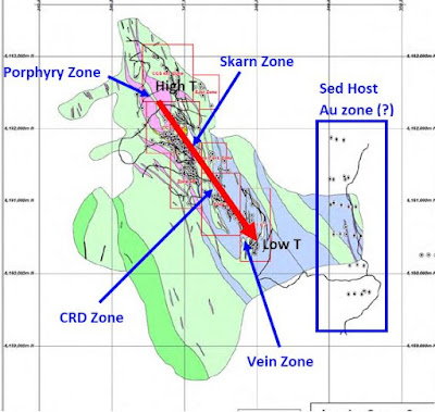
I'm just focusing on the skarn mineralization. I know that the project has several other mineralization styles, but they aren't the focus on the technical report, which suggests that they aren't important economically. You can get the 3D model from here (link), there was only a small proportion of the historic data that I could get in.


For those getting massive erections from the Porphyry zone, it has been drilled and no results are mentioned in the technical report, so I assume that it is unmineralized, but the lack of mineralization in it could be:

  • Negative (the majority of intrusive rocks) the magma that formed the stock was relatively metal poor, and therefore any mineralization associated with it will be small and uneconomic.
  • Positive (e.g. Santa Eulalia, Mexico; Taylor, Arizona, Las Bambas, Peru to name a few) – the stock was emplaced into a reactive rock (the limestones) that 'sucked' out all of the metals to form large skarn/CRD bodies leaving the behind an unmineralized porphyry.
However, the recent drilling (link and link) did look interesting. I wanted to check that they were doing more than confirmation drilling, i.e. twinning good old holes to con people into believing that they had found something new.


Simply put, they did a bit of both. Tested the known zones (probably because the historic core is missing), and they tested a few geophysical targets.

The good news that came out in October was from a confirmation hole (i.e. one that was drilled into an area that had been drilled before), and we got this section.


We can clearly see that the majority of the skarns are hosted in narrow limestone units within the phyllite package, which explains the narrow, irregular nature of the resources, which is not a good situation if you want to find a big deposit!


However, drill-hole 18SD-421 was good, it drilled through the phyllites and passed into the underlying limestones where it intersected 2 previously unknown, thick, high-grade skarn/massive sulfide zones.

This is great news as it shows that Sun Metals has found something new, rather than rehashing old news, and it appears that this phyllite-limestone contact is virtually undrilled! This zone appears to be open in most directions, especially up-dip.

The down-dip potential could be limited by hole LD2010-02 that may have drilled the down-dip continuation of this zone but hit nothing, but the hole may have been terminated before hitting the mineralized horizon.

I don't know the ground conditions at Stardust, but maybe there is an opportunity to reenter and extend holes 013 and 016 to drill through the phyllite-limestone contact as this would allow them to quickly determine (in 2D) the orientation and up-dip extent of this new skarn zone.

In summary, Sun Metals have a well explored project, but the discovery by hole 421 has identified a new target that has returned the highest-grade and thickest skarn intercepts on the project. However, with just a single hole intersecting this zone it is very hard to determine its size potential. 

In addition, they may want to look at conducting a down-hole geophysical survey, for example Mise-à-la-masse that has been used successfully in many other polymetallic sulphide deposits to determine its lateral extents.